Landskapet i Västjämtland och vid Enaforsholm
Landskapet i Västjämtland och vid Enaforsholm
Landskapet i Västjämtland och vid Enaforsholm

You also want an ePaper? Increase the reach of your titles
YUMPU automatically turns print PDFs into web optimized ePapers that Google loves.
hans antonson<br />
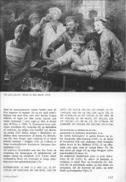
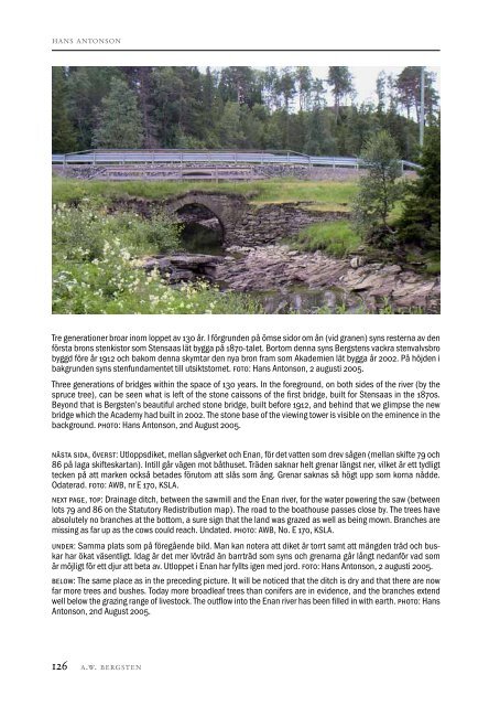
Tre generationer broar inom loppet av 130 år. I förgrunden på ömse sidor om ån (<strong>vid</strong> granen) syns resterna av den<br />
första brons stenkistor som Stensaas lät bygga på 1870-talet. Bortom denna syns Bergstens vackra stenvalvsbro<br />
byggd före år 1912 <strong>och</strong> bakom denna skymtar den nya bron fram som Akademien lät bygga år 2002. På höjden i<br />
bakgrunden syns stenfundamentet till utsiktstornet. foto: Hans Antonson, 2 augusti 2005.<br />
Three generations of bridges within the space of 130 years. In the foreground, on both sides of the river (by the<br />
spruce tree), can be seen what is left of the stone caissons of the first bridge, built for Stensaas in the 1870s.<br />
Beyond that is Bergsten’s beautiful arched stone bridge, built before 1912, and behind that we glimpse the new<br />
bridge which the Academy had built in 2002. The stone base of the viewing tower is visible on the eminence in the<br />
background. photo: Hans Antonson, 2nd August 2005.<br />
nästa sida, överst: Utloppsdiket, mellan sågverket <strong>och</strong> Enan, för det vatten som drev sågen (mellan skifte 79 <strong>och</strong><br />
86 på laga skifteskartan). Intill går vägen mot båthuset. Träden saknar helt grenar längst ner, vilket är ett tydligt<br />
tecken på att marken också betades förutom att slås som äng. Grenar saknas så högt upp som korna nådde.<br />
Odaterad. foto: AWB, nr E 170, KSLA.<br />
next page, top: Drainage ditch, between the sawmill and the Enan river, for the water powering the saw (between<br />
lots 79 and 86 on the Statutory Redistribution map). The road to the boathouse passes close by. The trees have<br />
absolutely no branches at the bottom, a sure sign that the land was grazed as well as being mown. Branches are<br />
missing as far up as the cows could reach. Undated. photo: AWB, No. E 170, KSLA.<br />
under: Samma plats som på föregående bild. Man kan notera att diket är torrt samt att mängden träd <strong>och</strong> buskar<br />
har ökat väsentligt. Idag är det mer lövträd än barrträd som syns <strong>och</strong> grenarna går långt nedanför vad som<br />
är möjligt för ett djur att beta av. Utloppet i Enan har fyllts igen med jord. foto: Hans Antonson, 2 augusti 2005.<br />
below: The same place as in the preceding picture. It will be noticed that the ditch is dry and that there are now<br />
far more trees and bushes. Today more broadleaf trees than conifers are in e<strong>vid</strong>ence, and the branches extend<br />
well below the grazing range of livestock. The outflow into the Enan river has been filled in with earth. photo: Hans<br />
Antonson, 2nd August 2005.<br />
126 a.w. bergsten<br />
Bergsten 2, Antonson, Landskap.indd 126 2012-09-18 01:13:21