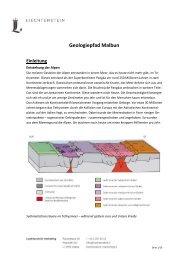
Princely Hikes in Liechtenstein
Which country in Europe has the densest network of hiking trails? It’s not the alpine classics of Switzerland or Austria, but in fact the small Principality of Liechtenstein nestling between those two countries. More than 400 kilometres of well-maintained and clearly signposted trails and majestic mountains up to 2600 metres above sea level attract walkers and hikers to Liechtenstein.
Which country in Europe has the densest network of hiking trails? It’s not the alpine classics of Switzerland or Austria, but in fact the small Principality of Liechtenstein nestling between those two countries. More than 400 kilometres of well-maintained and clearly signposted trails and majestic mountains up to 2600 metres above sea level attract walkers and hikers to Liechtenstein.

You also want an ePaper? Increase the reach of your titles
YUMPU automatically turns print PDFs into web optimized ePapers that Google loves.
16 → tourismus.li/hik<strong>in</strong>g<br />
WALKING TRAIL<br />
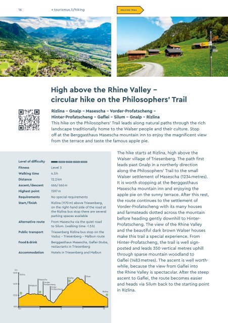
High above the Rh<strong>in</strong>e Valley –<br />
circular hike on the Philosophers’ Trail<br />
Rizl<strong>in</strong>a - Gnalp - Masescha - Vorder-Profatscheng -<br />
H<strong>in</strong>ter-Profatscheng – Gaflei – Silum – Gnalp – Rizl<strong>in</strong>a<br />
This hike on the Philosophers’ Trail leads along natural paths through the rich<br />
landscape traditionally home to the Walser people and their culture. Stop<br />
off at the Berggasthaus Masescha mounta<strong>in</strong> <strong>in</strong>n to enjoy the magnificent view<br />
from the terrace and taste the famous apple pie.<br />
hm<br />
1600<br />
1400<br />
1200<br />
Level of difficulty<br />
Fitness Level 3<br />
Walk<strong>in</strong>g time<br />
Distance<br />
Ascent/descent<br />
Highest po<strong>in</strong>t<br />
Requirements<br />
Start/f<strong>in</strong>ish<br />
Alternative route<br />
Public transport<br />
Food & dr<strong>in</strong>k<br />
Accommodation<br />
Rizl<strong>in</strong>a<br />
Mitätsch<br />
Masescha<br />
4.5 h<br />
Vorder-<br />
Profatscheng<br />
12.2 km<br />
666/666 m<br />
1597 m<br />
No special requirements<br />
Rizl<strong>in</strong>a (1170 m) above Triesenberg,<br />
on the right-hand side of the road at<br />
the Rizl<strong>in</strong>a bus stop there are several<br />
park<strong>in</strong>g spaces available<br />
From Masescha via the quiet road<br />
to Silum. (walk<strong>in</strong>g time -1.5 h)<br />
Triesenberg Rizl<strong>in</strong>a bus stop on the<br />
Vaduz – Triesenberg – Malbun route<br />
Berggasthaus Masescha, Gaflei-Stuba,<br />
restaurants <strong>in</strong> Triesenberg<br />
Hotels <strong>in</strong> Triesenberg and Malbun<br />
H<strong>in</strong>ter-<br />
Profatscheng<br />
Gaflei<br />
Silum<br />
Rizl<strong>in</strong>a<br />
The hike starts at Rizl<strong>in</strong>a, high above the<br />
Walser village of Triesenberg. The path first<br />
leads past Gnalp <strong>in</strong> a northerly direction<br />
along the Philosophers’ Trail to the small<br />
Walser settlement of Masescha (1234 metres).<br />
It is worth stopp<strong>in</strong>g at the Berggasthaus<br />
Masescha mounta<strong>in</strong> <strong>in</strong>n and enjoy<strong>in</strong>g the<br />
apple pie on the sunny terrace. After this rest,<br />
the route cont<strong>in</strong>ues to the settlement of<br />
Vorder-Profatscheng with its many houses<br />
and farmsteads dotted across the mounta<strong>in</strong><br />
before head<strong>in</strong>g gently downhill to H<strong>in</strong>ter-<br />
Profatscheng. The view of the Rh<strong>in</strong>e Valley<br />
and the beautiful dark brown Walser houses<br />
make this trail a special experience. From<br />
H<strong>in</strong>ter-Profatscheng, the trail is well signposted<br />
and leads 350 vertical metres uphill<br />
through sparse mounta<strong>in</strong> woodland to<br />
Gaflei (1483 metres). The ascent is well worthwhile,<br />
because the view from Gaflei <strong>in</strong>to<br />
the Rh<strong>in</strong>e Valley is spectacular. After the steep<br />
ascent to Gaflei, the route becomes easier<br />
and heads via Silum back to the start<strong>in</strong>g po<strong>in</strong>t<br />
<strong>in</strong> Rizl<strong>in</strong>a.<br />
1000<br />
km 3 6 9 12