Princely Hikes in Liechtenstein
Which country in Europe has the densest network of hiking trails? It’s not the alpine classics of Switzerland or Austria, but in fact the small Principality of Liechtenstein nestling between those two countries. More than 400 kilometres of well-maintained and clearly signposted trails and majestic mountains up to 2600 metres above sea level attract walkers and hikers to Liechtenstein.
Which country in Europe has the densest network of hiking trails? It’s not the alpine classics of Switzerland or Austria, but in fact the small Principality of Liechtenstein nestling between those two countries. More than 400 kilometres of well-maintained and clearly signposted trails and majestic mountains up to 2600 metres above sea level attract walkers and hikers to Liechtenstein.

Create successful ePaper yourself
Turn your PDF publications into a flip-book with our unique Google optimized e-Paper software.
38 → tourismus.li/hik<strong>in</strong>g<br />
HIKING TRAIL<br />
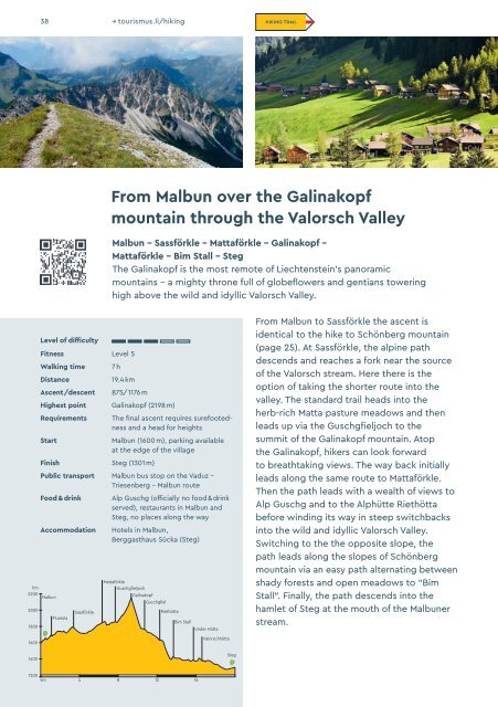
From Malbun over the Gal<strong>in</strong>akopf<br />
mounta<strong>in</strong> through the Valorsch Valley<br />
Malbun – Sassförkle – Mattaförkle – Gal<strong>in</strong>akopf –<br />
Mattaförkle – Bim Stall – Steg<br />
The Gal<strong>in</strong>akopf is the most remote of Liechtenste<strong>in</strong>’s panoramic<br />
mounta<strong>in</strong>s – a mighty throne full of globeflowers and gentians tower<strong>in</strong>g<br />
high above the wild and idyllic Valorsch Valley.<br />
hm<br />
2200<br />
2000<br />
1800<br />
Level of difficulty<br />
Fitness Level 5<br />
Walk<strong>in</strong>g time<br />
Distance<br />
Ascent/descent<br />
7 h<br />
19.4 km<br />
875/1176 m<br />
Highest po<strong>in</strong>t Gal<strong>in</strong>akopf (2198 m)<br />
Requirements<br />
Start<br />
F<strong>in</strong>ish Steg (1301 m)<br />
The f<strong>in</strong>al ascent requires surefootedness<br />
and a head for heights<br />
Malbun (1600 m), park<strong>in</strong>g available<br />
at the edge of the village<br />
Public transport Malbun bus stop on the Vaduz –<br />
Triesenberg – Malbun route<br />
Food & dr<strong>in</strong>k<br />
Accommodation<br />
Malbun<br />
Fluatola<br />
Sassförkle<br />
Alp Guschg (officially no food & dr<strong>in</strong>k<br />
served), restaurants <strong>in</strong> Malbun and<br />
Steg, no places along the way<br />
Hotels <strong>in</strong> Malbun,<br />
Berggasthaus Sücka (Steg)<br />
Mattaförkle<br />
Guschgfieljoch<br />
Gal<strong>in</strong>akopf<br />
Guschgfiel<br />
Riethötta<br />
Bim Stall<br />
Under Hötta<br />
From Malbun to Sassförkle the ascent is<br />
identical to the hike to Schönberg mounta<strong>in</strong><br />
(page 25). At Sassförkle, the alp<strong>in</strong>e path<br />
descends and reaches a fork near the source<br />
of the Valorsch stream. Here there is the<br />
option of tak<strong>in</strong>g the shorter route <strong>in</strong>to the<br />
valley. The standard trail heads <strong>in</strong>to the<br />
herb-rich Matta pasture meadows and then<br />
leads up via the Guschgfieljoch to the<br />
summit of the Gal<strong>in</strong>akopf mounta<strong>in</strong>. Atop<br />
the Gal<strong>in</strong>akopf, hikers can look forward<br />
to breathtak<strong>in</strong>g views. The way back <strong>in</strong>itially<br />
leads along the same route to Mattaförkle.<br />
Then the path leads with a wealth of views to<br />
Alp Guschg and to the Alphütte Riethötta<br />
before w<strong>in</strong>d<strong>in</strong>g its way <strong>in</strong> steep switchbacks<br />
<strong>in</strong>to the wild and idyllic Valorsch Valley.<br />
Switch<strong>in</strong>g to the the opposite slope, the<br />
path leads along the slopes of Schönberg<br />
mounta<strong>in</strong> via an easy path alternat<strong>in</strong>g between<br />
shady forests and open meadows to “Bim<br />
Stall”. F<strong>in</strong>ally, the path descends <strong>in</strong>to the<br />
hamlet of Steg at the mouth of the Malbuner<br />
stream.<br />
1600<br />
1400<br />
Valorschhötta<br />
Steg<br />
1200<br />
km 4 8 12 16