Princely Hikes in Liechtenstein
Which country in Europe has the densest network of hiking trails? It’s not the alpine classics of Switzerland or Austria, but in fact the small Principality of Liechtenstein nestling between those two countries. More than 400 kilometres of well-maintained and clearly signposted trails and majestic mountains up to 2600 metres above sea level attract walkers and hikers to Liechtenstein.
Which country in Europe has the densest network of hiking trails? It’s not the alpine classics of Switzerland or Austria, but in fact the small Principality of Liechtenstein nestling between those two countries. More than 400 kilometres of well-maintained and clearly signposted trails and majestic mountains up to 2600 metres above sea level attract walkers and hikers to Liechtenstein.

You also want an ePaper? Increase the reach of your titles
YUMPU automatically turns print PDFs into web optimized ePapers that Google loves.
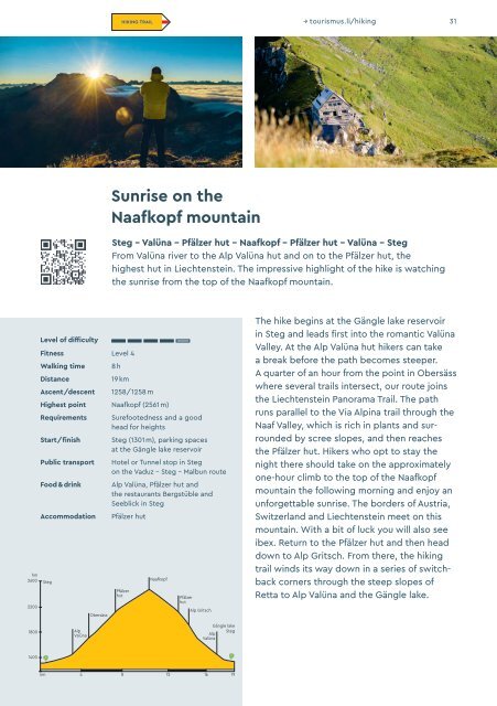
HIKING TRAIL → tourismus.li/hik<strong>in</strong>g 31<br />
Sunrise on the<br />
Naafkopf mounta<strong>in</strong><br />
Steg – Valüna – Pfälzer hut – Naafkopf – Pfälzer hut – Valüna – Steg<br />
From Valüna river to the Alp Valüna hut and on to the Pfälzer hut, the<br />
highest hut <strong>in</strong> Liechtenste<strong>in</strong>. The impressive highlight of the hike is watch<strong>in</strong>g<br />
the sunrise from the top of the Naafkopf mounta<strong>in</strong>.<br />
hm<br />
2600<br />
2200<br />
Level of difficulty<br />
Fitness Level 4<br />
Walk<strong>in</strong>g time<br />
Distance<br />
Ascent/descent<br />
8 h<br />
19 km<br />
1258/1258 m<br />
Highest po<strong>in</strong>t Naafkopf (2561 m)<br />
Requirements<br />
Start/f<strong>in</strong>ish<br />
Public transport<br />
Food & dr<strong>in</strong>k<br />
Accommodation<br />
Steg<br />
Obersäss<br />
Surefootedness and a good<br />
head for heights<br />
Steg (1301 m), park<strong>in</strong>g spaces<br />
at the Gängle lake reservoir<br />
Hotel or Tunnel stop <strong>in</strong> Steg<br />
on the Vaduz – Steg – Malbun route<br />
Alp Valüna, Pfälzer hut and<br />
the restaurants Bergstüble and<br />
Seeblick <strong>in</strong> Steg<br />
Pfälzer hut<br />
Pfälzer<br />
hut<br />
Naafkopf<br />
Pfälzer<br />
hut<br />
Alp Gritsch<br />
The hike beg<strong>in</strong>s at the Gängle lake reservoir<br />
<strong>in</strong> Steg and leads first <strong>in</strong>to the romantic Valüna<br />
Valley. At the Alp Valüna hut hikers can take<br />
a break before the path becomes steeper.<br />
A quarter of an hour from the po<strong>in</strong>t <strong>in</strong> Obersäss<br />
where several trails <strong>in</strong>tersect, our route jo<strong>in</strong>s<br />
the Liechtenste<strong>in</strong> Panorama Trail. The path<br />
runs parallel to the Via Alp<strong>in</strong>a trail through the<br />
Naaf Valley, which is rich <strong>in</strong> plants and surrounded<br />
by scree slopes, and then reaches<br />
the Pfälzer hut. Hikers who opt to stay the<br />
night there should take on the approximately<br />
one-hour climb to the top of the Naaf kopf<br />
mounta<strong>in</strong> the follow<strong>in</strong>g morn<strong>in</strong>g and enjoy an<br />
unforgettable sunrise. The borders of Austria,<br />
Switzerland and Liechtenste<strong>in</strong> meet on this<br />
mounta<strong>in</strong>. With a bit of luck you will also see<br />
ibex. Return to the Pfälzer hut and then head<br />
down to Alp Gritsch. From there, the hik<strong>in</strong>g<br />
trail w<strong>in</strong>ds its way down <strong>in</strong> a series of switchback<br />
corners through the steep slopes of<br />
Retta to Alp Valüna and the Gängle lake.<br />
1800<br />
Alp<br />
Valüna<br />
Gängle lake<br />
Steg<br />
Alp<br />
Valüna<br />
1400<br />
km 4 8 12 16 19