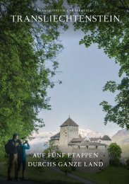
Princely Hikes in Liechtenstein
Which country in Europe has the densest network of hiking trails? It’s not the alpine classics of Switzerland or Austria, but in fact the small Principality of Liechtenstein nestling between those two countries. More than 400 kilometres of well-maintained and clearly signposted trails and majestic mountains up to 2600 metres above sea level attract walkers and hikers to Liechtenstein.
Which country in Europe has the densest network of hiking trails? It’s not the alpine classics of Switzerland or Austria, but in fact the small Principality of Liechtenstein nestling between those two countries. More than 400 kilometres of well-maintained and clearly signposted trails and majestic mountains up to 2600 metres above sea level attract walkers and hikers to Liechtenstein.

You also want an ePaper? Increase the reach of your titles
YUMPU automatically turns print PDFs into web optimized ePapers that Google loves.
HIKING TRAIL → tourismus.li/hik<strong>in</strong>g 29<br />
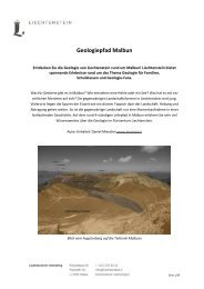
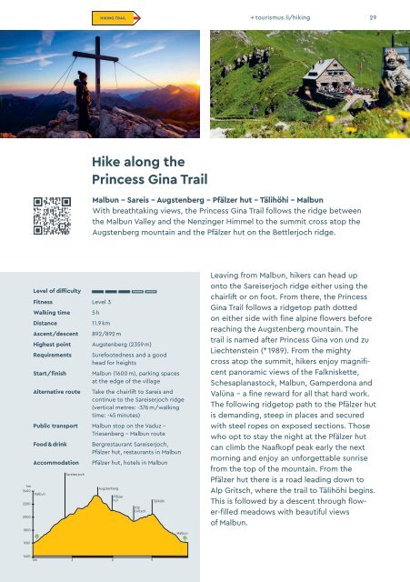
Hike along the<br />
Pr<strong>in</strong>cess G<strong>in</strong>a Trail<br />
Malbun – Sareis – Augstenberg – Pfälzer hut – Tälihöhi – Malbun<br />
With breathtak<strong>in</strong>g views, the Pr<strong>in</strong>cess G<strong>in</strong>a Trail follows the ridge between<br />
the Malbun Valley and the Nenz<strong>in</strong>ger Himmel to the summit cross atop the<br />
Augstenberg mounta<strong>in</strong> and the Pfälzer hut on the Bettlerjoch ridge.<br />
hm<br />
2400<br />
2200<br />
2000<br />
1800<br />
Level of difficulty<br />
Fitness Level 3<br />
Walk<strong>in</strong>g time<br />
Distance<br />
Ascent/descent<br />
5 h<br />
11.9 km<br />
892/892 m<br />
Highest po<strong>in</strong>t Augstenberg (2359 m)<br />
Requirements<br />
Start/f<strong>in</strong>ish<br />
Alternative route<br />
Surefootedness and a good<br />
head for heights<br />
Malbun (1600 m), park<strong>in</strong>g spaces<br />
at the edge of the village<br />
Take the chairlift to Sareis and<br />
cont<strong>in</strong>ue to the Sareiserjoch ridge<br />
(vertical metres: -376 m/walk<strong>in</strong>g<br />
time: -45 m<strong>in</strong>utes)<br />
Public transport Malbun stop on the Vaduz –<br />
Triesenberg – Malbun route<br />
Food & dr<strong>in</strong>k<br />
Accommodation<br />
Malbun<br />
Sareiserjoch<br />
Bergrestaurant Sareiserjoch,<br />
Pfälzer hut, restaurants <strong>in</strong> Malbun<br />
Pfälzer hut, hotels <strong>in</strong> Malbun<br />
Augstenberg<br />
Pfälzer<br />
hut<br />
Alp<br />
Gritsch<br />
Tälihöhi<br />
Malbun<br />
Leav<strong>in</strong>g from Malbun, hikers can head up<br />
onto the Sareiserjoch ridge either us<strong>in</strong>g the<br />
chairlift or on foot. From there, the Pr<strong>in</strong>cess<br />
G<strong>in</strong>a Trail follows a ridgetop path dotted<br />
on either side with f<strong>in</strong>e alp<strong>in</strong>e flowers before<br />
reach<strong>in</strong>g the Augstenberg mounta<strong>in</strong>. The<br />
trail is named after Pr<strong>in</strong>cess G<strong>in</strong>a von und zu<br />
Liechtenste<strong>in</strong> († 1989). From the mighty<br />
cross atop the summit, hikers enjoy magnificent<br />
panoramic views of the Falkniskette,<br />
Schesaplanastock, Malbun, Gamperdona and<br />
Valüna – a f<strong>in</strong>e reward for all that hard work.<br />
The follow<strong>in</strong>g ridgetop path to the Pfälzer hut<br />
is demand<strong>in</strong>g, steep <strong>in</strong> places and secured<br />
with steel ropes on exposed sections. Those<br />
who opt to stay the night at the Pfälzer hut<br />
can climb the Naafkopf peak early the next<br />
morn<strong>in</strong>g and enjoy an unforgettable sunrise<br />
from the top of the mounta<strong>in</strong>. From the<br />
Pfälzer hut there is a road lead<strong>in</strong>g down to<br />
Alp Gritsch, where the trail to Tälihöhi beg<strong>in</strong>s.<br />
This is followed by a descent through flower-filled<br />
meadows with beautiful views<br />
of Malbun.<br />
1600<br />
1400<br />
km 3 6<br />
9