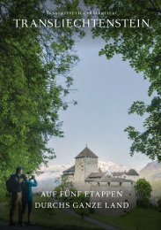
Princely Hikes in Liechtenstein
Which country in Europe has the densest network of hiking trails? It’s not the alpine classics of Switzerland or Austria, but in fact the small Principality of Liechtenstein nestling between those two countries. More than 400 kilometres of well-maintained and clearly signposted trails and majestic mountains up to 2600 metres above sea level attract walkers and hikers to Liechtenstein.
Which country in Europe has the densest network of hiking trails? It’s not the alpine classics of Switzerland or Austria, but in fact the small Principality of Liechtenstein nestling between those two countries. More than 400 kilometres of well-maintained and clearly signposted trails and majestic mountains up to 2600 metres above sea level attract walkers and hikers to Liechtenstein.

Create successful ePaper yourself
Turn your PDF publications into a flip-book with our unique Google optimized e-Paper software.
BERGWANDERWEG<br />
HIKING TRAIL → tourismus.li/hik<strong>in</strong>g 27<br />
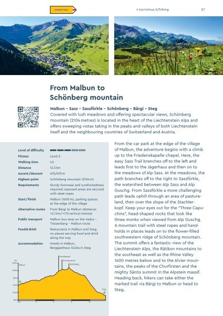
From Malbun to<br />
Schönberg mounta<strong>in</strong><br />
Malbun - Sass - Sassförkle - Schönberg - Bärgi - Steg<br />
Covered with lush meadows and offer<strong>in</strong>g spectacular views, Schönberg<br />
mounta<strong>in</strong> (2104 metres) is located <strong>in</strong> the heart of the Liechtenste<strong>in</strong> Alps and<br />
offers sweep<strong>in</strong>g vistas tak<strong>in</strong>g <strong>in</strong> the peaks and valleys of both Liechtenste<strong>in</strong><br />
itself and the neighbour<strong>in</strong>g countries of Switzerland and Austria.<br />
hm<br />
2200<br />
2000<br />
1800<br />
1600<br />
1400<br />
Level of difficulty<br />
Fitness Level 2<br />
Walk<strong>in</strong>g time<br />
Distance<br />
Ascent/descent<br />
4 h<br />
12.5 km<br />
670/670 m<br />
Highest po<strong>in</strong>t Schönberg mounta<strong>in</strong> (2104 m)<br />
Requirements<br />
Start/f<strong>in</strong>ish<br />
Alternative routes<br />
Sturdy footwear and surefootedness<br />
required; exposed areas are secured<br />
with steel ropes<br />
Malbun (1600 m), park<strong>in</strong>g spaces<br />
at the edge of the village<br />
From Bärgi to Malbun (distance:<br />
+2.1 km/+175 vertical metres)<br />
Public transport Malbun bus stop on the Vaduz –<br />
Triesenberg – Malbun route<br />
Food & dr<strong>in</strong>k<br />
Accommodation<br />
Malbun<br />
Restaurants <strong>in</strong> Malbun and Steg;<br />
no places serv<strong>in</strong>g food and dr<strong>in</strong>k<br />
along the way<br />
Hotels <strong>in</strong> Malbun,<br />
Berggasthaus Sücka <strong>in</strong> Steg<br />
Stachlerkopf<br />
Drei Kapuz<strong>in</strong>er<br />
Schönberg<br />
Steg<br />
From the car park at the edge of the village<br />
of Malbun, the adventure beg<strong>in</strong>s with a climb<br />
up to the Friedenskapelle chapel. Here, the<br />
easy Sass Trail branches off to the left and<br />
leads first to the Jägerhaus and then on to<br />
the meadows of Alp Sass. At the meadows, the<br />
path branches off to the right to Sassförkle,<br />
the watershed between Alp Sass and Alp<br />
Guschg. From Sassförkle a more challeng<strong>in</strong>g<br />
path leads uphill through an area of pastureland,<br />
then over the slope of the Stachler -<br />
kopf. Keep your eyes out for the “Three Capuch<strong>in</strong>s”,<br />
head-shaped rocks that look like<br />
three monks when viewed from Alp Guschg.<br />
A mounta<strong>in</strong> trail with steel ropes and handholds<br />
<strong>in</strong> places leads on to the flower-filled<br />
southwestern ridge of Schönberg mounta<strong>in</strong>.<br />
The summit offers a fantastic view of the<br />
Liechtenste<strong>in</strong> Alps, the Rätikon mounta<strong>in</strong>s to<br />
the southeast as well as the Rh<strong>in</strong>e Valley<br />
1600 metres below and to the Alvier mounta<strong>in</strong>s,<br />
the peaks of the Churfirsten and the<br />
mighty Säntis summit <strong>in</strong> the Alpste<strong>in</strong> massif.<br />
Head<strong>in</strong>g back, hikers can take either the<br />
marked trail via Bärgi to Malbun or head to<br />
Steg.<br />
1200<br />
km 2 4 6 8