Princely Hikes in Liechtenstein
Which country in Europe has the densest network of hiking trails? It’s not the alpine classics of Switzerland or Austria, but in fact the small Principality of Liechtenstein nestling between those two countries. More than 400 kilometres of well-maintained and clearly signposted trails and majestic mountains up to 2600 metres above sea level attract walkers and hikers to Liechtenstein.
Which country in Europe has the densest network of hiking trails? It’s not the alpine classics of Switzerland or Austria, but in fact the small Principality of Liechtenstein nestling between those two countries. More than 400 kilometres of well-maintained and clearly signposted trails and majestic mountains up to 2600 metres above sea level attract walkers and hikers to Liechtenstein.

You also want an ePaper? Increase the reach of your titles
YUMPU automatically turns print PDFs into web optimized ePapers that Google loves.
HIKING TRAIL → tourismus.li/hik<strong>in</strong>g 33<br />
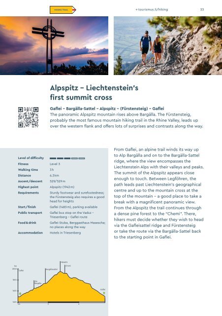
Alpspitz – Liechtenste<strong>in</strong>’s<br />
first summit cross<br />
Gaflei – Bargälla-Sattel – Alpspitz – (Fürstensteig) – Gaflei<br />
The panoramic Alpspitz mounta<strong>in</strong> rises above Bargälla. The Fürstensteig,<br />
probably the most famous mounta<strong>in</strong> hik<strong>in</strong>g trail <strong>in</strong> the Rh<strong>in</strong>e Valley, leads up<br />
over the western flank and offers lots of surprises and contrasts along the way.<br />
Level of difficulty<br />
Fitness Level 3<br />
Walk<strong>in</strong>g time<br />
Distance<br />
Ascent/descent<br />
3 h<br />
6.3 km<br />
529/529 m<br />
Highest po<strong>in</strong>t Alpspitz (1942 m)<br />
Requirements<br />
Start/f<strong>in</strong>ish<br />
Sturdy footwear and surefootedness;<br />
the Fürstensteig also requires a good<br />
head for heights<br />
Gaflei (1483 m), park<strong>in</strong>g available<br />
Public transport Gaflei bus stop on the Vaduz –<br />
Triesenberg – Gaflei route<br />
Food & dr<strong>in</strong>k<br />
Accommodation<br />
Gaflei-Stuba, Berggasthaus Masescha;<br />
no places along the way<br />
Hotels <strong>in</strong> Triesenberg<br />
From Gaflei, an alp<strong>in</strong>e trail w<strong>in</strong>ds its way up<br />
to Alp Bargälla and on to the Bargälla-Sattel<br />
ridge, where the view encompasses the<br />
Liechtenste<strong>in</strong> Alps with their valleys and peaks.<br />
The summit of the Alpspitz appears close<br />
enough to touch. Between Legföhren, the<br />
path leads past Liechtenste<strong>in</strong>’s geographical<br />
centre and up to the mounta<strong>in</strong> cross at the<br />
top of the mounta<strong>in</strong> – a good place to take a<br />
break with a magnificent panoramic view.<br />
From the Alpspitz the trail cont<strong>in</strong>ues through<br />
a dense p<strong>in</strong>e forest to the “Chemi”. There,<br />
hikers must decide whether they wish to head<br />
via the Gafleisattel ridge and Fürstensteig<br />
or take the route via the Bargälla-Sattel back<br />
to the start<strong>in</strong>g po<strong>in</strong>t <strong>in</strong> Gaflei.<br />
hm<br />
2000<br />
Gaflei<br />
Bargällasattel<br />
Alpspitz<br />
Chemi<br />
1800<br />
Alp<br />
Bargälla<br />
1600<br />
Gaflei<br />
1400<br />
km 2 4