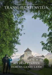
Princely Hikes in Liechtenstein
Which country in Europe has the densest network of hiking trails? It’s not the alpine classics of Switzerland or Austria, but in fact the small Principality of Liechtenstein nestling between those two countries. More than 400 kilometres of well-maintained and clearly signposted trails and majestic mountains up to 2600 metres above sea level attract walkers and hikers to Liechtenstein.
Which country in Europe has the densest network of hiking trails? It’s not the alpine classics of Switzerland or Austria, but in fact the small Principality of Liechtenstein nestling between those two countries. More than 400 kilometres of well-maintained and clearly signposted trails and majestic mountains up to 2600 metres above sea level attract walkers and hikers to Liechtenstein.

You also want an ePaper? Increase the reach of your titles
YUMPU automatically turns print PDFs into web optimized ePapers that Google loves.
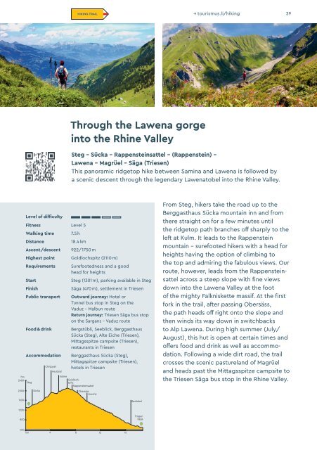
HIKING TRAIL → tourismus.li/hik<strong>in</strong>g 39<br />
Through the Lawena gorge<br />
<strong>in</strong>to the Rh<strong>in</strong>e Valley<br />
Steg – Sücka – Rappenste<strong>in</strong>sattel – (Rappenste<strong>in</strong>) –<br />
Lawena – Magrüel – Säga (Triesen)<br />
This panoramic ridgetop hike between Sam<strong>in</strong>a and Lawena is followed by<br />
a scenic descent through the legendary Lawenatobel <strong>in</strong>to the Rh<strong>in</strong>e Valley.<br />
hm<br />
2400<br />
Level of difficulty<br />
Fitness Level 5<br />
Walk<strong>in</strong>g time<br />
Distance<br />
Ascent/descent<br />
7.5 h<br />
18.4 km<br />
922/1750 m<br />
Highest po<strong>in</strong>t Goldlochspitz (2110 m)<br />
Requirements<br />
Start<br />
F<strong>in</strong>ish<br />
Public transport<br />
Food & dr<strong>in</strong>k<br />
Accommodation<br />
Steg<br />
Chrüppel<br />
Heubüal<br />
Kolme<br />
Surefootedness and a good<br />
head for heights<br />
Steg (1301 m), park<strong>in</strong>g available <strong>in</strong> Steg<br />
Säga (470 m), settlement <strong>in</strong> Triesen<br />
Outward journey: Hotel or<br />
Tunnel bus stop <strong>in</strong> Steg on the<br />
Vaduz – Malbun route<br />
Return journey: Triesen Säga bus stop<br />
on the Sargans – Vaduz route<br />
Bergstübli, Seeblick, Berggasthaus<br />
Sücka (Steg), Alte Eiche (Triesen),<br />
Mittagsspitze campsite (Triesen),<br />
restaurants <strong>in</strong> Triesen<br />
Berggasthaus Sücka (Steg),<br />
Mittagspitze campsite (Triesen),<br />
hotels <strong>in</strong> Triesen<br />
Goldlochspitz<br />
Rappenste<strong>in</strong>sattel<br />
From Steg, hikers take the road up to the<br />
Berggasthaus Sücka mounta<strong>in</strong> <strong>in</strong>n and from<br />
there straight on for a few m<strong>in</strong>utes until<br />
the ridgetop path branches off sharply to the<br />
left at Kulm. It leads to the Rappenste<strong>in</strong><br />
mounta<strong>in</strong> – surefooted hikers with a head for<br />
heights hav<strong>in</strong>g the option of climb<strong>in</strong>g to<br />
the top and admir<strong>in</strong>g the fabulous views. Our<br />
route, however, leads from the Rappenste<strong>in</strong>sattel<br />
across a steep slope with f<strong>in</strong>e views<br />
down <strong>in</strong>to the Lawena Valley at the foot<br />
of the mighty Falkniskette massif. At the first<br />
fork <strong>in</strong> the trail, after pass<strong>in</strong>g Obersäss,<br />
the path heads off right onto the slope and<br />
then w<strong>in</strong>ds its way down <strong>in</strong> switchbacks<br />
to Alp Lawena. Dur<strong>in</strong>g high summer (July/<br />
August), this hut is open at certa<strong>in</strong> times and<br />
offers food and dr<strong>in</strong>k as well as accommodation.<br />
Follow<strong>in</strong>g a wide dirt road, the trail<br />
crosses the scenic pastureland of Magrüel<br />
and heads past the Mittagsspitze campsite to<br />
the Triesen Säga bus stop <strong>in</strong> the Rh<strong>in</strong>e Valley.<br />
2000<br />
Sücka<br />
Obersäss<br />
Lawena<br />
1600<br />
Badtobel<br />
1200<br />
800<br />
Triesen<br />
Säga<br />
400<br />
km 4 8 12 16