PDF, 3 MB - CENIA, ÄÂeská informaÄÂnàagentura životnÃÂho prostředÃÂ
PDF, 3 MB - CENIA, ÄÂeská informaÄÂnàagentura životnÃÂho prostředÃÂ
PDF, 3 MB - CENIA, ÄÂeská informaÄÂnàagentura životnÃÂho prostředÃÂ
- No tags were found...

Create successful ePaper yourself
Turn your PDF publications into a flip-book with our unique Google optimized e-Paper software.
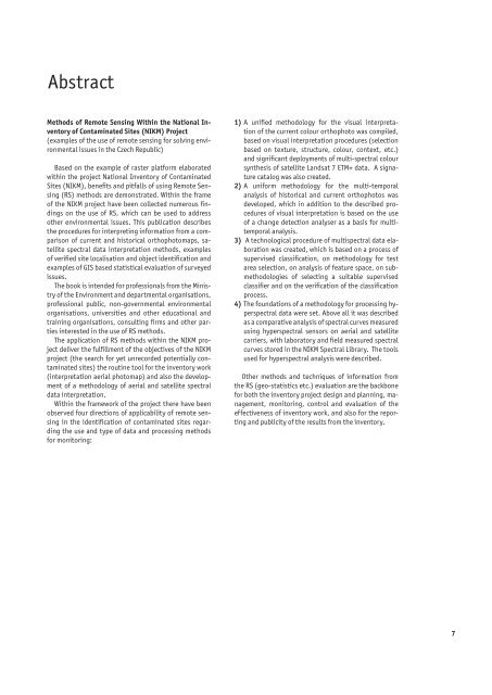
Abstract<br />
Methods of Remote Sensing Within the National Inventory<br />
of Contaminated Sites (NIKM) Project<br />
(examples of the use of remote sensing for solving environmental<br />
issues in the Czech Republic)<br />
Based on the example of raster platform elaborated<br />
within the project National Inventory of Contaminated<br />
Sites (NIKM), benefits and pitfalls of using Remote Sensing<br />
(RS) methods are demonstrated. Within the frame<br />
of the NIKM project have been collected numerous findings<br />
on the use of RS, which can be used to address<br />
other environmental issues. This publication describes<br />
the procedures for interpreting information from a comparison<br />
of current and historical orthophotomaps, satellite<br />
spectral data interpretation methods, examples<br />
of verified site localisation and object identification and<br />
examples of GIS based statistical evaluation of surveyed<br />
issues.<br />
The book is intended for professionals from the Ministry<br />
of the Environment and departmental organisations,<br />
professional public, non-governmental environmental<br />
organisations, universities and other educational and<br />
training organisations, consulting firms and other parties<br />
interested in the use of RS methods.<br />
The application of RS methods within the NIKM project<br />
deliver the fulfillment of the objectives of the NIKM<br />
project (the search for yet unrecorded potentially contaminated<br />
sites) the routine tool for the inventory work<br />
(interpretation aerial photomap) and also the development<br />
of a methodology of aerial and satellite spectral<br />
data interpretation.<br />
Within the framework of the project there have been<br />
observed four directions of applicability of remote sensing<br />
in the identification of contaminated sites regarding<br />
the use and type of data and processing methods<br />
for monitoring:<br />
1) A unified methodology for the visual interpretation<br />
of the current colour orthophoto was compiled,<br />
based on visual interpretation procedures (selection<br />
based on texture, structure, colour, context, etc.)<br />
and significant deployments of multi-spectral colour<br />
synthesis of satellite Landsat 7 ETM+ data. A signature<br />
catalog was also created.<br />
2) A uniform methodology for the multi-temporal<br />
analysis of historical and current orthophotos was<br />
deve loped, which in addition to the described procedures<br />
of visual interpretation is based on the use<br />
of a change detection analyser as a basis for multitemporal<br />
analysis.<br />
3) A technological procedure of multispectral data elaboration<br />
was created, which is based on a process of<br />
supervised classification, on methodology for test<br />
area selection, on analysis of feature space, on submethodologies<br />
of selecting a suitable supervised<br />
classifier and on the verification of the classification<br />
process.<br />
4) The foundations of a methodology for processing hyperspectral<br />
data were set. Above all it was described<br />
as a comparative analysis of spectral curves measured<br />
using hyperspectral sensors on aerial and satellite<br />
carriers, with laboratory and field measured spectral<br />
curves stored in the NIKM Spectral Library. The tools<br />
used for hyperspectral analysis were described.<br />
Other methods and techniques of information from<br />
the RS (geo-statistics etc.) evaluation are the back bone<br />
for both the inventory project design and planning, management,<br />
monitoring, control and evaluation of the<br />
effectiveness of inventory work, and also for the reporting<br />
and publicity of the results from the inventory.<br />
7