berichte 2011 - Förderergesellschaft der Geodäsie und ...
berichte 2011 - Förderergesellschaft der Geodäsie und ...
berichte 2011 - Förderergesellschaft der Geodäsie und ...

Erfolgreiche ePaper selbst erstellen
Machen Sie aus Ihren PDF Publikationen ein blätterbares Flipbook mit unserer einzigartigen Google optimierten e-Paper Software.
36<br />
BERTA: B ESCHREIBUNG UND KORREKTUR VON GNSS-M EHRWEG-EFFEKTEN MITTELS<br />
RAY-TRACING UND SOFTWARE-E MPFÄNGERN (BMWI/DLR, MARIOS SMYRNIAOS)<br />
BERTA project is realized through the corporation of the Institut für<br />
Erdmessung (IfE) and the Institut für Nachrichtentechnik (IfN) of the Technical<br />
University of Braunschweig.<br />
The primary goal of the project is to investigate and un<strong>der</strong>stand multipath<br />
propagation effects in GNSS receivers so that a model can be <strong>der</strong>ived for<br />
the correction of phase observations.<br />
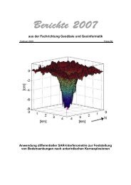
CARRIER-TO-NOISE DENSITY RATIO VALUES FOR SATELLITE PRN16 AT TWO DAYS OBSERVED IN<br />
A ZERO BASELINE SCENARIO WITH TWO RECEIVERS (LEICA/JAVAD)<br />
High precision GNSS applications, like GNSS reference station applications,<br />
require mm accuracy while phase errors due to multipath propagation<br />
may reach up to cm level. Consi<strong>der</strong>ing the fact that most of the other<br />
GNSS error sources can be modelled or significantly reduced by differential<br />
techniques, site dependent errors and multipath propagation especially<br />
are very crucial for the achieved positioning accuracy. The previous justifies<br />
the intense research that takes place in the last decades in the field of<br />
multipath detection and/or mitigation.<br />
In the current investigation, a ray-tracing method is used to model deterministically<br />
the satellite-to-earth channel. Simulated ray paths characteristics<br />
are very useful for the deeper un<strong>der</strong>standing of the process. Moreover<br />
the disturbances between the simulations and the actual GNSS observations,<br />
both from geodetic and software GNSS receivers, will lead us to a<br />
correction model for the phase observations.