Volume 56, Number 3 December 2012 Photo by Denice Drass
Volume 56, Number 3 December 2012 Photo by Denice Drass
Volume 56, Number 3 December 2012 Photo by Denice Drass

Create successful ePaper yourself
Turn your PDF publications into a flip-book with our unique Google optimized e-Paper software.
Tropical Atlantic and Tropical east pacific Areas<br />
<strong>December</strong> <strong>2012</strong> ~ Mariners Weather Log<br />
28<br />
Tropical Atlantic and Tropical East Pacific Areas<br />
May through August <strong>2012</strong><br />
Pre and Post Deb<strong>by</strong> Gale Events<br />
Prior to the development of Tropical Storm Deb<strong>by</strong>, TAFB<br />
issued a gale warning at 1200 UTC 23 Jun for 6 hours in<br />
association with Deb<strong>by</strong>’s precursor low in the eastern portion<br />
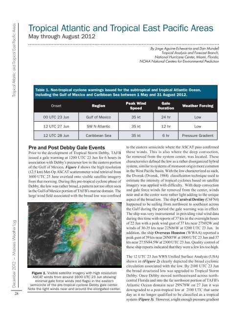
of the Gulf of Mexico. Figure 1 shows the high resolution<br />
(12.5 km) Met-Op ASCAT scatterometer wind retrieval from<br />
1600 UTC 23 June overlaid onto visible satellite imagery<br />
from that morning. During this pre-tropical cyclone phase of<br />
Deb<strong>by</strong>, the low was rather broad, a pattern not too often seen<br />
in the Gulf of Mexico portion of TAFB’s marine domain. The<br />
large wind field associated with the broad low was confined<br />
By Jorge Aguirre-Echevarria and Dan Mundell<br />
Tropical Analysis and Forecast Branch,<br />
National Hurricane Center, Miami, Florida,<br />
NOAA National Centers for Environmental Prediction<br />
Table 1. Non-tropical cyclone warnings issued for the subtropical and tropical Atlantic Ocean,<br />
including the Gulf of Mexico and Caribbean Sea between 1 May and 31 August <strong>2012</strong>.<br />
Onset Region<br />
Peak Wind<br />
Speed<br />
Gale<br />
Duration<br />
Weather Forcing<br />
00 UTC 23 Jun gulf of Mexico 35 kt 24 hr Low<br />
12 UTC 27 Jun SW N Atlantic 35 kt 12 hr Low<br />
12 UTC 28 Jun Caribbean Sea 35 kt 6 hr Pressure gradient<br />
Figure 1. Visible satellite imagery with high resolution<br />
ASCAT winds from around 1600 UTC 23 Jun showing<br />
minimal gale force winds (red flags) in the eastern<br />
semicircle of the pre-tropical cyclone Deb<strong>by</strong> gale center.<br />
Note the light winds near and around the elongated center.<br />
to the eastern semicircle where the ASCAT pass confirmed<br />
these winds. This is also where the deep convection,<br />
far removed from the system center, was located. These<br />
characteristics defined the low as a rather disorganized hybrid<br />
system, similar to systems of monsoon origin more common<br />
in the West Pacific basin. With the low characterized as such,<br />
the Dvorak (Dvorak, 1984) classification technique used to<br />
estimate the intensity of tropical cyclones based on satellite<br />
imagery was applied with difficulty. With deep convection<br />
and gale force winds far removed from the center, winds<br />
near and at the center were rather light adding to the unique<br />
aspect of the broad low. The ship Carnival Destiny (C6FN4)<br />
happened to be sailing from northwest to southeast across<br />
the Gulf during the period the gale warning was in effect.<br />
The ship was very instrumental in providing vital wind data<br />
during this time with reports of 37 kts in the overnight hours<br />
of 22 Jun with a peak wind gust of 37 kts near 27N92W and<br />
winds of 30-35 kts near 22N86W at 1200 UTC 23 Jun. In<br />
addition, the ship Overseas Houston (WWAA) reported a<br />
peak gust of 39 kts near 28N85W at 1800 UTC 23 Jun and 37<br />
kts near 27.5N84.5W at 2300 UTC 23 Jun. Quality control of<br />
these ship reports indicated that they were a few kts too high.<br />
The 12 UTC 23 Jun NWS Unified Surface Analysis (USA)<br />
shown in (Figure 2) clearly depicted the broad cyclonic<br />
circulation associated with the low. By 2100 UTC 23 Jun<br />
the broad structured low was upgraded to Tropical Storm<br />
Deb<strong>by</strong>. Once Deb<strong>by</strong> moved northeastward across northcentral<br />
Florida and into the far northwest portion of TAFB’s<br />
Atlantic Ocean domain near 29N78W on 27 Jun it was<br />
downgraded to a post-tropical low at 2100 UTC that same<br />
day as it no longer qualified to be classified as a tropical<br />
system (Figure 3). However, a tight enough pressure gradient