Volume 56, Number 3 December 2012 Photo by Denice Drass
Volume 56, Number 3 December 2012 Photo by Denice Drass
Volume 56, Number 3 December 2012 Photo by Denice Drass

You also want an ePaper? Increase the reach of your titles
YUMPU automatically turns print PDFs into web optimized ePapers that Google loves.
North Atlantic Area<br />
<strong>December</strong> <strong>2012</strong> ~ Mariners Weather Log<br />
34<br />
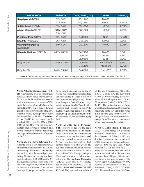
OBSERVATION POSITION DATE/TIME (UTC) WIND SEA(m/f)<br />
Singelgracht (PCGM) 37N 64W<br />
37N 66W<br />
North Atlantic Storm, January 22-<br />
25: A developing low passed northeast<br />
across Atlantic Canada late on January<br />
20 th and on the 21 st and became a storm<br />
with a lowest central pressure of 978<br />
mb in the northern Labrador Sea on the<br />
night of the 22 nd . The cyclone re formed<br />
east of southern Greenland on the 23 rd ,<br />
where it briefly developed hurricane<br />
force winds late on the 23 rd . The Irena<br />
Artica (BATEU05) encountered north<br />
winds of 50 kts near 59N 42W at 1200<br />
UTC on the 24 th . The low pressure<br />
system then drifted southeast and<br />
slowly weakened over the following<br />
two days and dissipated west of Ireland<br />
on the 25 th .<br />
North Atlantic Storm, February 2-6:<br />
A frontal wave of low pressure moved<br />
off the mid Atlantic coast of the U.S. on<br />
the morning of February 2 and rapidly<br />
intensified, with the central pressure<br />
falling 32 mb in the twenty four hour<br />
period ending at 1800 UTC on the 3 rd .<br />
The cyclone continued to intensify over<br />
the following two days while it lifted<br />
to the north northeast. The system<br />
developed two periods of hurricane<br />
03/1200<br />
03/1800<br />
force conditions, one late on the 3 rd<br />
when it was south of Newfoundland and<br />
the other on the 5 th when it was over<br />
the Labrador Sea (Figure 10). Some<br />
notable reports from ships and buoys<br />
in this event are listed in Table 1. After<br />
reaching peak intensity on the 5 th the<br />
cyclone weakened rapidly near the<br />
southern tip of Greenland late on the<br />
6 th and on the 7 th , before dissipating <strong>by</strong><br />
the 8 th .<br />
North Atlantic Storm, February<br />
8-10: Figure 11 depicts the rapid<br />
initial development of this hurricane<br />
force storm over the southwestern<br />
waters over a twenty four hour period,<br />
when the central pressure dropped<br />
28 mb. In spite of the relatively high<br />
central pressure in this event, the<br />
cyclone’s compact circulation resulted<br />
in hurricane force winds to 70 kts as<br />
detected <strong>by</strong> OSCAT imagery (Figure<br />
12) around the southwest and west sides<br />
of the low. The Sea-Land Champion<br />
(WKAU) near 46N 57W reported<br />
north winds of 50 kts at 0600 UTC on<br />
the 10 th . Hibernia Platform (VEP717,<br />
46.7N 48.7W) reported west winds of<br />
NW 60<br />
NW 50<br />
Sol Do Brasil (ELOQ4) 39N 64W 03/1800 NE 50<br />
4.5/15<br />
7.6/25<br />
Adrian Maersk (OXLD2) 38.5N 46W<br />
39N 43W<br />
03/1800 NE 50 7.6/25<br />
President Polk (WRYD) 42N 55W 04/0600 N 55 8.8/29<br />
Integrity (WDC6925) 36N 43W 04/1200 SW 65 7.6/25<br />
Washington Express<br />
(WDD3826)<br />
39N 41W 04/1200 SW 50 5.0/16<br />
Hibernia Platform (VEP717) 46.7N 48.7W 04/2100<br />
05/0000<br />
05/0300<br />
Buoy 44140 43.8N 51.5W 04/0900<br />
04/1100<br />
NW 65<br />
W 55<br />
W 55<br />
NW 45 G58<br />
Maximum<br />
6.5/21<br />
6.5/21<br />
7.0/23<br />
6.5/21<br />
8.0/26<br />
Buoy 44138 44.3N 53.6W 04/0600 N 41 G52 7.5/25<br />
Table 1. Selected ship and buoy observations taken during passage of North Atlantic storm, February 26, <strong>2012</strong>.<br />
65 kts and 6.5 meter seas (21 feet) at<br />
2100 UTC on the 10 th . The buoy 44141<br />
(43.0N 58.0W) reported northwest<br />
winds 47 kts with gusts to 62 kts and<br />
7.0 meter seas (23 feet) at 0400 UTC on<br />
the 10 th . The cyclone tracked northeast<br />
toward Iceland and gradually weakened<br />
beginning on the 10 th and its top winds<br />
diminished to gale force <strong>by</strong> the 11 th .<br />
The gale force low then turned east<br />
along 65N on February 12 th and moved<br />
inland over Norway the next day.<br />
North Atlantic Storm, February<br />
19-23: Developing low pressure<br />
moved off the southeast U.S. coast on<br />
the afternoon of February 19 th and<br />
developed hurricane force winds with<br />
a 968 mb center over the central waters<br />
near 42N 46W two days later. A high<br />
resolution ASCAT pass from 1200 UTC<br />
on the 22 nd revealed winds 50 to 60 kts<br />
in the south semicircle of the low center<br />
similar to those of Figure 14 for the next<br />
event except not quite as strong. The<br />
Kaveri Spirit (C6WK2) near 37N 44W<br />
reported south winds of 45 kts and 11.3<br />
meter seas (37 feet) at 1700 UTC on the<br />
21 st . Thirteen hours later the Porto