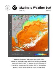
Volume 56, Number 3 December 2012 Photo by Denice Drass
Volume 56, Number 3 December 2012 Photo by Denice Drass
Volume 56, Number 3 December 2012 Photo by Denice Drass

You also want an ePaper? Increase the reach of your titles
YUMPU automatically turns print PDFs into web optimized ePapers that Google loves.
Tropical Atlantic and Tropical east pacific Areas<br />
<strong>December</strong> <strong>2012</strong> ~ Mariners Weather Log<br />
30<br />
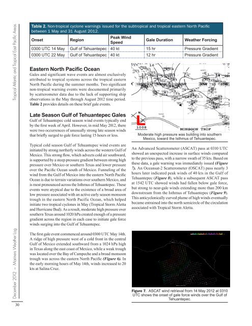
Table 2. Non-tropical cyclone warnings issued for the subtropical and tropical eastern North Pacific<br />
between 1 May and 31 August <strong>2012</strong>.<br />
Onset Region<br />
Peak Wind<br />
Speed<br />
Gale Duration Weather Forcing<br />
0300 UTC 14 May Gulf of Tehuantepec 40 kt 15 hr Pressure Gradient<br />
0300 UTC 22 May Gulf of Tehuantepec 40 kt 12 hr Pressure Gradient<br />
Eastern North Pacific Ocean<br />
Gales and significant wave events are almost exclusively<br />
attributed to tropical systems across the tropical eastern<br />
North Pacific during the summer months. Two significant<br />
non-tropical warning events were documented primarily<br />
<strong>by</strong> scatterometer data due to the lack of supporting ship<br />
observations in the May through August <strong>2012</strong> time period.<br />
Table 2 provides details on these brief gale events.<br />
Late Season Gulf of Tehuantepec Gales<br />
Gulf of Tehuantepec cold season wind events typically end<br />
<strong>by</strong> the first week of April. However, in mid May <strong>2012</strong>, there<br />
were two occurrences of unusually strong late season winds<br />
that briefly surged to gale force lasting 15 hours or less.<br />
Typical cold season Gulf of Tehuantepec wind events are<br />
initiated <strong>by</strong> strong northerly winds across the western Gulf of<br />
Mexico. This strong flow, which advects cold air southward,<br />
is supported <strong>by</strong> a steep pressure gradient between strong high<br />
pressure over Mexico or southern Texas and lower pressure<br />
over the Pacific Ocean south of Mexico. Funneling of the<br />
wind from the Gulf of Mexico into the eastern North Pacific<br />
Ocean is due to terrain variations over southern Mexico, and<br />
is most pronounced across the Isthmus of Tehuantepec. These<br />
events were atypical due to the existence of a broad area of<br />
low pressure associated with an active early season monsoon<br />
trough in the eastern North Pacific Ocean, which helped<br />
initiate two tropical cyclones in May (Tropical Storm Aletta<br />
and Hurricane Bud). As a result, moderate high pressure over<br />
southern Texas around 1020 hPa created enough of a pressure<br />
gradient across the region in each case to initiate gale force<br />
winds surging into the Gulf of Tehuantepec.<br />
The first gale event commenced around 0300 UTC May 14th.<br />
A ridge of high pressure west of a cold front in the central<br />
Gulf of Mexico extended southward from a 1024 hPa high<br />
in Texas along the east coast of Mexico, while a weak trough<br />
was located over the Bay of Campeche and a broad monsoon<br />
trough was across the eastern North Pacific (Figure 6). In<br />
the early morning hours of May 14th, winds increased to 20<br />
kts at Salina Cruz.<br />
Figure 6. National Weather Service Unified Surface<br />
Analysis (USA) chart from 1800 UTC 13 May <strong>2012</strong>,<br />
centered on southern Mexico and Central America.<br />
Moderate high pressure was building into southern<br />
Mexico, toward the Isthmus of Tehuantepec.<br />
An Advanced Scatterometer (ASCAT) pass at 0310 UTC<br />
showed an unexpected increase in surface winds compared<br />
to the previous pass, with a narrow swath of 35 kts. Based on<br />
these data, a gale warning was immediately issued (Figure<br />
7). An Oceansat-2 Scatterometer (OSCAT) pass nearly 3<br />
hours later indicated peak winds of 40 kts in the Gulf of<br />
Tehuantepec (Figure 8), while a subsequent ASCAT pass<br />
at 1542 UTC showed winds had fallen below gale force,<br />
but strong to near-gale winds extending more than 200 km<br />
downstream from the Isthmus of Tehuantepec (Figure 9).<br />
This anticyclonically curved plume of high winds eventually<br />
became entrained into the north semicircle of the circulation<br />
associated with Tropical Storm Aletta.<br />
Figure 7. ASCAT wind retrieval from 14 May <strong>2012</strong> at 0310<br />
UTC shows the onset of gale force winds over the Gulf of<br />
Tehuantepec.