Volume 56, Number 3 December 2012 Photo by Denice Drass
Volume 56, Number 3 December 2012 Photo by Denice Drass
Volume 56, Number 3 December 2012 Photo by Denice Drass

You also want an ePaper? Increase the reach of your titles
YUMPU automatically turns print PDFs into web optimized ePapers that Google loves.
North pacific Area<br />
<strong>December</strong> <strong>2012</strong> ~ Mariners Weather Log<br />
42<br />
reported northeast winds of 55 kts and<br />
9.8 meter seas (32 feet) at 0600 UTC on<br />
the 10 th . Buoy 46035 (57.1N 177.8W)<br />
reported east winds of 45 kts with gusts<br />
to 54 kts at 1200 UTC on the 12 th and,<br />
eleven hours later, seas reaching 8.0<br />
meters (26 feet). The system turned<br />
toward the east and weakened while<br />
crossing the southern Bering Sea on the<br />
12 th and 13 th then dissipated in the Gulf<br />
of Alaska on the 14 th .<br />
Northeastern Pacific Storm, March<br />
18-20: The development of this<br />
cyclone over a thirty six hour period is<br />
shown in Figure 18. The second part<br />
of Figure 18 shows the hurricane force<br />
low at maximum intensity in terms<br />
of pressure. The Overseas Boston<br />
(WJBU) near 51N 133W reported south<br />
winds of 60 kts and 8.5 meter seas (28<br />
feet) at 0600 UTC on the 20 th , followed<br />
<strong>by</strong> a report of northwest winds 70 kts<br />
near 50N 132W six hours later. The<br />
Horizon Anchorage (KGTX) near 49N<br />
129W encountered seas of 11.9 meters<br />
(39 feet) along with southwest winds 35<br />
kts at 1800 UTC March 20. The buoy<br />
46036 (48.4N 133.9W) reported west<br />
winds of 43 kts with gusts to 54 kts at<br />
0900 UTC on the 20 th , and one hour<br />
prior, seas as high as 11.5 meters 38<br />
feet). The cyclone then moved onshore<br />
over Southeast Alaska and weakened<br />
rapidly late on the 20 th .<br />
Eastern North Pacific Storm,<br />
March 29-31: The first is shown fully<br />
developed as a hurricane force low<br />
off Northern California in Figure 19.<br />
It originated in the Sea of Okhotsk on<br />
the 24 th and tracked southeast and then<br />
east across the North Pacific and did<br />
not intensify until it crossed 160W. It<br />
is at maximum intensity in Figure 19.<br />
A 25 km OSCAT image 0914 UTC<br />
reveals northwest winds to 70 kts on<br />
the southwest side of the low and winds<br />
as high as 55 kts ahead of the occluded<br />
front. The Ever Diamond (3FQJ8) near<br />
38N 160W reported northwest winds<br />
of 45 kts and 8.5 meter seas (28 feet) at<br />
0300 UTC on the 30 th . The ship WRTF<br />
(44N 129W) encountered east winds<br />
of 55 kts at 0900 UTC on the 31 st . The<br />
cyclone then moved inland over Oregon<br />
and weakened on the night of the 31 st .<br />
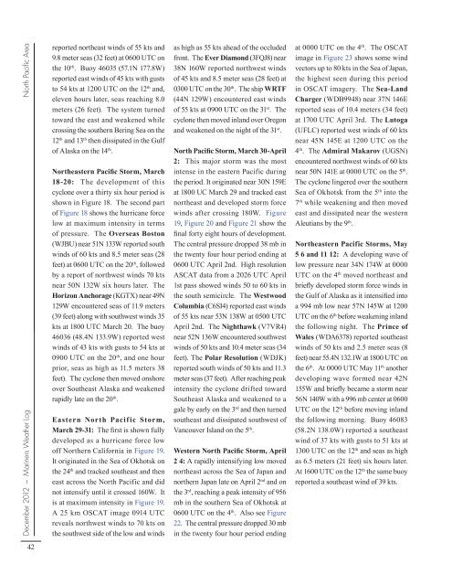
North Pacific Storm, March 30-April<br />
2: This major storm was the most<br />
intense in the eastern Pacific during<br />
the period. It originated near 30N 159E<br />
at 1800 UC March 29 and tracked east<br />
northeast and developed storm force<br />
winds after crossing 180W. Figure<br />
19, Figure 20 and Figure 21 show the<br />
final forty eight hours of development.<br />
The central pressure dropped 38 mb in<br />
the twenty four hour period ending at<br />
0600 UTC April 2nd. High resolution<br />
ASCAT data from a 2026 UTC April<br />
1st pass showed winds 50 to 60 kts in<br />
the south semicircle. The Westwood<br />
Columbia (C6SI4) reported east winds<br />
of 55 kts near 53N 138W at 0500 UTC<br />
April 2nd. The Nighthawk (V7VR4)<br />
near 52N 136W encountered southwest<br />
winds of 50 kts and 10.4 meter seas (34<br />
feet). The Polar Resolution (WDJK)<br />
reported south winds of 50 kts and 11.3<br />
meter seas (37 feet). After reaching peak<br />
intensity the cyclone drifted toward<br />
Southeast Alaska and weakened to a<br />
gale <strong>by</strong> early on the 3 rd and then turned<br />
southeast and dissipated southwest of<br />
Vancouver Island on the 5 th .<br />
Western North Pacific Storm, April<br />
2 4: A rapidly intensifying low moved<br />
northeast across the Sea of Japan and<br />
northern Japan late on April 2 nd and on<br />
the 3 rd , reaching a peak intensity of 9<strong>56</strong><br />
mb in the southern Sea of Okhotsk at<br />
0600 UTC on the 4 th . Also see Figure<br />
22. The central pressure dropped 30 mb<br />
in the twenty four hour period ending<br />
at 0000 UTC on the 4 th . The OSCAT<br />
image in Figure 23 shows some wind<br />
vectors up to 80 kts in the Sea of Japan,<br />
the highest seen during this period<br />
in OSCAT imagery. The Sea-Land<br />
Charger (WDB9948) near 37N 146E<br />
reported seas of 10.4 meters (34 feet)<br />
at 1700 UTC April 3rd. The Lutoga<br />
(UFLC) reported west winds of 60 kts<br />
near 45N 145E at 1200 UTC on the<br />
4 th . The Admiral Makarov (UGSN)<br />
encountered northwest winds of 60 kts<br />
near 50N 141E at 0000 UTC on the 5 th .<br />
The cyclone lingered over the southern<br />
Sea of Okhotsk from the 5 th into the<br />
7 th while weakening and then moved<br />
east and dissipated near the western<br />
Aleutians <strong>by</strong> the 9 th .<br />
Northeastern Pacific Storms, May<br />
5 6 and 11 12: A developing wave of<br />
low pressure near 34N 174W at 0000<br />
UTC on the 4 th moved northeast and<br />
briefly developed storm force winds in<br />
the Gulf of Alaska as it intensified into<br />
a 994 mb low near 57N 145W at 1200<br />
UTC on the 6 th before weakening inland<br />
the following night. The Prince of<br />
Wales (WDA6378) reported southeast<br />
winds of 50 kts and 2.5 meter seas (8<br />
feet) near 55.4N 132.1W at 1800 UTC on<br />
the 6 th . At 0000 UTC May 11 th another<br />
developing wave formed near 42N<br />
155W and briefly became a storm near<br />
<strong>56</strong>N 140W with a 996 mb center at 0600<br />
UTC on the 12 th before moving inland<br />
the following morning. Buoy 46083<br />
(58.2N 138.0W) reported a southeast<br />
wind of 37 kts with gusts to 51 kts at<br />
1300 UTC on the 12 th and seas as high<br />
as 6.5 meters (21 feet) six hours later.<br />
At 1600 UTC on the 12 th the same buoy<br />
reported a southeast wind of 39 kts.