Rural Income Generation and Diversification - A Case Study ... - Doria
Rural Income Generation and Diversification - A Case Study ... - Doria
Rural Income Generation and Diversification - A Case Study ... - Doria

You also want an ePaper? Increase the reach of your titles
YUMPU automatically turns print PDFs into web optimized ePapers that Google loves.
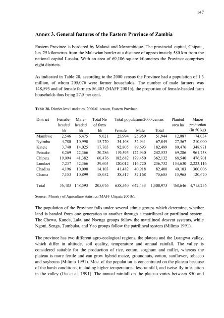
Annex 3. General features of the Eastern Province of Zambia<br />
Eastern Province is bordered by Malawi <strong>and</strong> Mozambique. The provincial capital, Chipata,<br />
lies 25 kilometres from the Malawian border at a distance of approximately 580 km from the<br />
national capital Lusaka. With an area of 69,106 square kilometres the Province comprises<br />
eight districts.<br />
As indicated in Table 28, according to the 2000 census the Province had a population of 1.3<br />
million, of whom 205,076 were farmer households. The number of male farmers was<br />
148,593 <strong>and</strong> of female farmers 56,483 (MAFF 2001b), the proportion of female-headed farm<br />
households thus being 27.5 per cent.<br />
Table 28. District-level statistics, 2000/01 season, Eastern Province.<br />
District Femaleheaded<br />
hh<br />
Maleheaded<br />
hh<br />
Total No<br />
of farm<br />
hh<br />
Total population/2000 census<br />
Female Male Total<br />
Planted<br />
area ha<br />
147<br />
Maize<br />
production<br />
(in 50 kg)<br />
Mambwe 2,546 6,475 9,021 25,994 25,950 51,944 12,087 74,034<br />
Nyimba 4,780 10,990 15,770 34,108 32,941 67,049 27,567 210,000<br />
Katete 3,740 14,025 17,765 92,805 89,693 182,489 80,476 348,971<br />
Petauke 8,269 22,366 30,286 119,593 122,940 242,533 69,286 961,758<br />
Chipata 19,094 41,382 60,476 182,682 179,450 362,132 68,540 476,701<br />
Lundazi 7,237 32,366 39,603 120,012 116,720 236,732 154,630 2,223,116<br />
Chadiza 4,196 10,090 14,103 41,482 40,918 82,400 40,103 300,006<br />
Chama 7,153 10,899 18,052 38,517 37,168 75,685 15,965 120,670<br />
Total 56,483 148,593 205,076 658,540 642,433 1,300,973 468,646 4,715,256<br />
Source: Ministry of Agriculture statistics (MAFF Chipata 2001b).<br />
The population of the Province falls under several ethnic groups which determine, whether<br />
l<strong>and</strong> is h<strong>and</strong>ed from one generation to another through a matrilineal or patrilineal system.<br />
The Chewa, Kunda, Lala, <strong>and</strong> Nsenga groups follow the matrilineal descent systems, while<br />
Ngoni, Senga, Tumbuka, <strong>and</strong> Yao groups follow the patrilineal system (Milimo 1991).<br />
The province has two different agro-ecological regions, the plateau <strong>and</strong> the Luangwa valley,<br />
which differ in altitude, soil quality, temperature <strong>and</strong> annual rainfall. The valley is<br />
considered suitable for the production of rice, cotton, sorghum <strong>and</strong> millet, whereas the<br />
plateau is more fertile <strong>and</strong> can grow hybrid maize, groundnuts, cotton, sunflower, tobacco<br />
<strong>and</strong> soybeans (Milimo 1991). Most of the population is concentrated on the plateau because<br />
of the harsh conditions, including higher temperatures, less rainfall, <strong>and</strong> tsetse-fly infestation<br />
in the valley (Jha et al. 1991). The annual rainfall on the plateau varies between 850 <strong>and</strong>