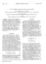
1854 NEWELL ET AL: DC-8 SAMPLING OF TYPHOON MIREILLE ElI0 N45 4O 35 3O 25 2O 15 10 N5 ... ...... 115 120 125 130 135 140 145 150 155 160 165 170 BEST TRACK TC-21W !' ' 13 SEP- 28 SEP 91 MAX SFC WIND 130KT .... ! ........... +++ : 281 ............ ........... ' MINIMUM SLP 910MB 0ki .... '::,::::. ':..:." ........... "'5 i ':'": ' Isla ..... : .4..:::% : 10. 2 : ß 110, 115 . : 115 :!'11 115 .. .:. '11 . :'Keting 1 .. i:25 7125 t :.}':' ':'.. ':::" !25 ....... i ................. 24 39 85! ..?.i ::;.::..: ..:.i: 130 "' .... i ......... ...... ::..::7 : 130, '" :": " [ .'..:.:.:.'... i ß .. !. : .. 24 .: :.. 1251 85 20 19. LEGEND 6-tIR BEST 'IRACK POSITION SPEED OF MOV 'EMENT (KT) INTENSITY (KT) POSITION AT XXAXX)0Z TROPICAL DISTURBANCE 'IROPICAL DEPRESSION TROPICAL STORM TYPI lOON SUP[]*, TYPIIOON END EX'IRA'IROPICAL SUPER SUBTROPICAL TYPIIOON START DISSIPATING STAGE FIRST WARNING ISSUED LAST WARNING ISSUF_.D 65 175E F- 16/00Z ..TCA .......................... 18 17 16 *""7øøo !ABpw 15 /i øo ................................... .................... Figure 1. Track <strong>of</strong> Typhoon <strong>Mireille</strong> from September 13-28, 1991 [from Rudolph and Guard, 1992]. Positions <strong>of</strong> ground stations Kenting and Oki Island are noted. Aeronautics and Space Administration, has carried out atmospheric <strong>sampling</strong> in various regions <strong>of</strong> the world. In the typhoon system, there is a substantial lateral inflow <strong>of</strong> air in the lower troposphere to compensate for Measurements are used here from flights through a typhoon during the Pacific Exploratory Mission-West A (PEM-West A) <strong>NASA</strong> DC-8 deployment to the western the rising convective motions and outflow al<strong>of</strong>t, and these quasi-horizontal flows are also important in redistributing trace constituents. An opportunity to carry out an Pacific in September-October 1991. The instrumentation experiment to check this redistribution was presented when carded on the DC-8 is described by Hoe# et al. [this issue] Typhoon <strong>Mireille</strong> approached an area to the south <strong>of</strong> Japan and the background meteorology by Bachmeier et al. [this which could be accessed from Tokyo. Air emering the issue]. Sampling was plmmed in two separate seasons: one typhoon in the surface boundary layer, in the eye itself, toward the end <strong>of</strong> the summer monsoon and the other emerging from the eye and surrounding wall cloud region toward the end <strong>of</strong> the winter monsoon. The summer in the upper troposphere, was sampled. monsoon <strong>of</strong> the tropical western Pacific always includes a Typhoon <strong>Mireille</strong> was first noted on the weather maps number <strong>of</strong> typhoons; five occurred during the 6 weeks <strong>of</strong> as a significant system on September 13, 1991, when the first PEM-West deployment. The large-scale positioned at 12øN, 172øE moving westward (see Figure 1) manifestation <strong>of</strong> atmospheric convection that these [from Rudolph and Guard, 1992] and qualified as a typhoons represent could be important in the redistribution typhoon, <strong>with</strong> 1-min sustained winds exceeding 32 ms 'l, <strong>of</strong> atmospheric trace constituents. In some previous on September 16 while at 15øN, 157øE. By September 22 it had turned toward the northwest and winds had increased discussions <strong>of</strong> typhoons, there was debate as to why the air mass in the eye was apparently different from the to 67 ms -1, qualifying <strong>Mireille</strong> as a "super typhoon." After surrounding air mass. Bergeron [1954], referring to the September 23, <strong>Mireille</strong> began to slowly weaken, although work <strong>of</strong> others, noted that "The two air masses are its size, as measured by the diameter <strong>of</strong> its outermost separated by a boundary zone which sometimes has been closed isobar, continued to increase. On September 26, taken for the tmpopause itself, sucked down from its <strong>Mireille</strong> turned northward, then northeastward, and made normal height .... " In Bergeron's view, "It is more land in western Kyushu at about 0600 UT on September plausible that this boundary zone has been formed by a 27. During the evening <strong>of</strong> September 27 it passed over the similar process <strong>with</strong>in the tropospheric air itself." In the Sea <strong>of</strong> Japan and gradually lost force, passing over present experiment, ozone, a good stratospheric tracer, was northern Honshu and southern Hokkaido early on measured to test these ideas. September 28.
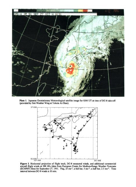
- q m ,. mm mmm m II Plate 1. Japanese Geostationary Meteorological satellite image for 0200 UT at time <strong>of</strong> DC-8 take-<strong>of</strong>f (provided by first Weather Wing at Yokota Air Base). 37.00N ./ 27 00E 141.00E Fi.r½ 2. Horizontal projection <strong>of</strong> flight track, DC-8 measured winds, nd dditional commercial aircraft flight winds at 288 hPa (data from European Centre for Medium-Range Weather Forecasts (ECMWF) files) for September 27, 1991. Flag, 25 ms-l; a full bar, 5 ms-l; a half bar, 2.5 ms -1. Time interval between DC-8 winds is 10 min.