Atmospheric sampling of Supertyphoon Mireille with NASA ...
Atmospheric sampling of Supertyphoon Mireille with NASA ...
Atmospheric sampling of Supertyphoon Mireille with NASA ...

Create successful ePaper yourself
Turn your PDF publications into a flip-book with our unique Google optimized e-Paper software.
32.80N<br />
5:<br />
31.70N I<br />
128.40E<br />
37.00N<br />
30.00N<br />
128.00E<br />
NEWELL ET AL' DC-8 SAMPLING OF TYPHOON MIREILLE ! 857<br />
5:30<br />
5:: 13<br />
:1o<br />
/ : 7:10 7:14<br />
__--- -- -- - ..... i,- 7:00 ......<br />
5:32<br />
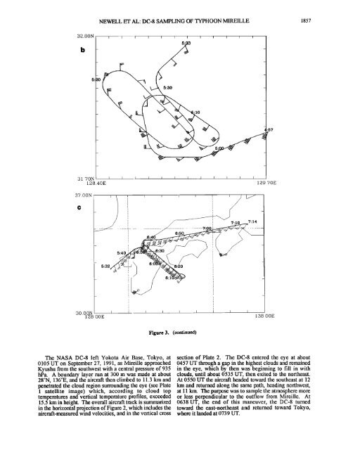
Figure 3. (continued)<br />
The <strong>NASA</strong> DC-8 left Yokota Air Base, Tokyo, at section <strong>of</strong> Plate 2. The DC-8 entered the eye at about<br />
0105 UT on September 27, 1991, as <strong>Mireille</strong> approached 0457 UT through a gap in the highest clouds and remained<br />
Kyushu from the southwest <strong>with</strong> a central pressure <strong>of</strong> 935 in the eye, which by then was beginning to fill in <strong>with</strong><br />
hPa. A boundary layer mn at 300 rn was made at about clouds, until about 0535 UT, then exited to the northeast.<br />
28øN, 136øE, and the aircraft then climbed to 11.3 km and At 0550 UT the aircraft headed toward the southeast at 12<br />
penetrated the cloud region surrounding the eye (see Plate km and returned along the same path, heading northwest,<br />
1 satellite image) which, according to cloud top at 11 km. The purpose was to sample the atmosphere more<br />
temperatures and vertical temperature pr<strong>of</strong>iles, exceeded or less perpendicular to the outflow from <strong>Mireille</strong>. At<br />
15.5 km in height. The overall aircraft track is summarized 0638 UT, the end <strong>of</strong> this maneuver, the DC-8 turned<br />
in the horizontal projection <strong>of</strong> Figure 2, which includes the toward the east-northeast and returned toward Tokyo,<br />
aircraft-measured wind velocities, and in the vertical cross where it landed at 0739 UT.<br />
.:57<br />
129.70E<br />
138.00E