Biodiversity Profile of Afghanistan - Disasters and Conflicts - UNEP
Biodiversity Profile of Afghanistan - Disasters and Conflicts - UNEP
Biodiversity Profile of Afghanistan - Disasters and Conflicts - UNEP

Create successful ePaper yourself
Turn your PDF publications into a flip-book with our unique Google optimized e-Paper software.
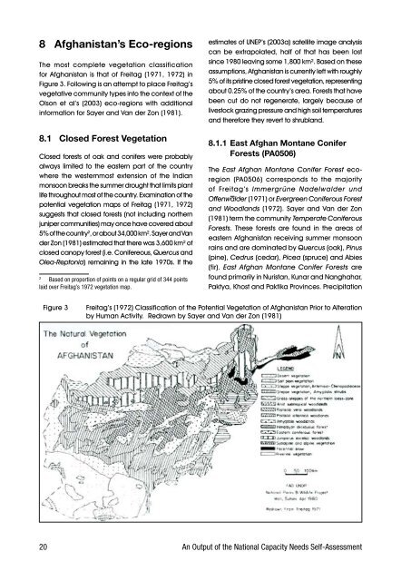
8 <strong>Afghanistan</strong>’s Eco-regions<br />
The. most. complete. vegetation. classification.<br />
for.<strong>Afghanistan</strong>.is.that.<strong>of</strong>.Freitag.(1971,.1972).in.<br />
Figure.3..Following.is.an.attempt.to.place.Freitag’s.<br />
vegetative.community.types.into.the.context.<strong>of</strong>.the.<br />
Olson. et. al’s. (2003). eco-regions. with. additional.<br />
information.for.Sayer.<strong>and</strong>.Van.der.Zon.(1981).<br />
8.1 Closed Forest Vegetation<br />
Closed.forests.<strong>of</strong>.oak.<strong>and</strong>.conifers.were.probably.<br />
always. limited. to. the. eastern. part. <strong>of</strong>. the. country.<br />
where. the. westernmost. extension. <strong>of</strong>. the. Indian.<br />
monsoon.breaks.the.summer.drought.that.limits.plant.<br />
life.throughout.most.<strong>of</strong>.the.country..Examination.<strong>of</strong>.the.<br />
potential.vegetation.maps.<strong>of</strong>.Freitag.(1971,.1972).<br />
suggests.that.closed.forests.(not.including.northern.<br />
juniper.communities).may.once.have.covered.about.<br />
5%.<strong>of</strong>.the.country 2 ,.or.about.34,000.km²..Sayer.<strong>and</strong>.Van.<br />
der.Zon.(1981).estimated.that.there.was.3,600.km².<strong>of</strong>.<br />
closed.canopy.forest.(i.e..Conifereous,.Quercus.<strong>and</strong>.<br />
Olea-Reptonia).remaining.in.the.late.1970s..If.the.<br />
.<br />
2 Based on proportion <strong>of</strong> points on a regular grid <strong>of</strong> 344 points<br />
laid over Freitag’s 1 2 vegetation map.<br />
estimates.<strong>of</strong>.<strong>UNEP</strong>’s.(2003a).satellite.image.analysis.<br />
can. be. extrapolated,. half. <strong>of</strong>. that. has. been. lost.<br />
since.1980.leaving.some.1,800.km²..Based.on.these.<br />
assumptions,.<strong>Afghanistan</strong>.is.currently.left.with.roughly.<br />
5%.<strong>of</strong>.its.pristine.closed.forest.vegetation,.representing.<br />
about.0.25%.<strong>of</strong>.the.country’s.area..Forests.that.have.<br />
been.cut.do.not.regenerate,.largely.because.<strong>of</strong>.<br />
livestock.grazing.pressure.<strong>and</strong>.high.soil.temperatures.<br />
<strong>and</strong>.therefore.they.revert.to.shrubl<strong>and</strong>..<br />
8.1.1 East Afghan Montane Conifer<br />
Forests (PA0506)<br />
The. East Afghan Montane Conifer Forest. ecoregion.<br />
(PA0506). corresponds. to. the. majority.<br />
<strong>of</strong>. Freitag’s. Immergrüne Nadelwalder und<br />
Offenwalder.(1971).or.Evergreen Coniferous Forest<br />
<strong>and</strong> Woodl<strong>and</strong>s.(1972)..Sayer.<strong>and</strong>.Van.der.Zon.<br />
(1981).term.the.community.Temperate Coniferous<br />
Forests.. These. forests. are. found. in. the. areas. <strong>of</strong>.<br />
eastern.<strong>Afghanistan</strong>.receiving.summer.monsoon.<br />
rains.<strong>and</strong>.are.dominated.by.Quercus.(oak),.Pinus.<br />
(pine),.Cedrus.(cedar),.Picea.(spruce).<strong>and</strong>.Abies.<br />
(fir).. East Afghan Montane Conifer Forests. are.<br />
found.primarily.in.Nuristan,.Kunar.<strong>and</strong>.Nanghahar,.<br />
Paktya,.Khost.<strong>and</strong>.Paktika.Provinces..Precipitation.<br />
Figure.3. Freitag’s.(1972).Classification.<strong>of</strong>.the.Potential.Vegetation.<strong>of</strong>.<strong>Afghanistan</strong>.Prior.to.Alteration.<br />
. . . . by.Human.Activity...Redrawn.by.Sayer.<strong>and</strong>.Van.der.Zon.(1981)<br />
20 An Output <strong>of</strong> the National Capacity Needs Self-Assessment