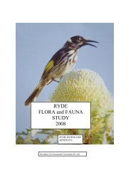
RYDE FLORA and FAUNA STUDY 2007 - City of Ryde - NSW ...
RYDE FLORA and FAUNA STUDY 2007 - City of Ryde - NSW ...
RYDE FLORA and FAUNA STUDY 2007 - City of Ryde - NSW ...

Create successful ePaper yourself
Turn your PDF publications into a flip-book with our unique Google optimized e-Paper software.
Biosphere Environmental Consultants Pty Ltd<br />
<strong>Ryde</strong> Flora <strong>and</strong> Fauna Survey <strong>2007</strong> 31<br />
Mangrove Saltmarsh Complex (see Estuarine quadrat in <strong>Ryde</strong> Flora <strong>and</strong> Fauna Study,<br />
2006) at 5m ASL that is influenced by the tidal changes within the Lane Cove River.<br />
Pidding Park is very interesting because it straddles both the Turpentine Ironbark<br />
community derived from Mittagong Formation geology at the top <strong>of</strong> the quadrat <strong>and</strong><br />
Western Sydney Gully Forest derived from Hawkesbury S<strong>and</strong>stone at the bottom <strong>of</strong><br />
the quadrat. This explains the high diversity <strong>of</strong> vegetation in the quadrat consisting <strong>of</strong><br />
both shale-loving <strong>and</strong> s<strong>and</strong>stone-loving species. In the Field <strong>of</strong> Mars Reserve the<br />
Turpentine Ironbark Margin communities (~40m ASL) straddle the ridge, which most<br />
likely contained Turpentine Ironbark <strong>and</strong>/or Shale S<strong>and</strong>stone Transition Forest before<br />
the cemetery was built. The southern-facing slopes contain Western S<strong>and</strong>stone Gully<br />
Forest while the northwest-facing slopes contain S<strong>and</strong>stone Ridgetop Woodl<strong>and</strong>.<br />
Barton Reserve, <strong>Ryde</strong><br />
Barton Reserve borders the north-south stormwater line flowing below Quarry &<br />
Pidding Roads to the east <strong>and</strong> residences to the west. This long linear reserve is<br />
located below a s<strong>and</strong>stone escarpment on Pidding Road <strong>and</strong> only tens <strong>of</strong> metres below<br />
the junction with the Wianamatta Shale soils found in Minga Reserve to the north.<br />
The northwest end <strong>of</strong> the park contains many Turpentines <strong>and</strong> is probably a remnant<br />
<strong>of</strong> Turpentine Ironbark Forest. There is a closed road entering the north end at Niara<br />
Street, which has been l<strong>and</strong>scaped with native plants. Below that is a fairly large<br />
regeneration area along the creek. A bush track heads south to exits at Forrest Road<br />
<strong>and</strong> the bottom <strong>of</strong> Pidding Road. Beyond that, the southern end <strong>of</strong> the park is heavily<br />
weed infested.<br />
The vegetation <strong>of</strong> this reserve is more diverse (87 species) than the smaller Pidding<br />
Park to the north (68 species) <strong>and</strong> bush regeneration work is showing promising<br />
results. The vegetation community is Western S<strong>and</strong>stone Gully Forest. An<br />
uncommon local species that has been planted in Barton Reserve is Acacia stricta<br />
(Kubiak, 2005).<br />
A weed to note is Isolepis prolifer, which regenerates from plantlets at the end <strong>of</strong> the<br />
stems <strong>and</strong> can spread rapidly if not controlled. It is in the drainage line entering from<br />
Quarry Road, just south from the bridge.<br />
4.5.3 Kittys Creek / Lane Cove River Catchment<br />
Portius Park <strong>and</strong> Kittys Creek Reserve, East <strong>Ryde</strong><br />
Portius Park <strong>and</strong> Kittys Creek Reserve are discussed together as the vegetation is very<br />
similar for both areas. These reserves form the core <strong>of</strong> the bushl<strong>and</strong> surrounding<br />
lower Kittys Creek. The northern end <strong>of</strong> Portius Park is just on the other side <strong>of</strong> the<br />
creek from Pryor Park <strong>and</strong> would most likely have had the same vegetation<br />
(Turpentine Ironbark Forest), but much has been cleared. The area has been heavily<br />
impacted upon <strong>and</strong> some sections are being restored by planting. An assemblage <strong>of</strong><br />
Red Mahogany in the cleared fire trail demarcates a change in soil from clay to s<strong>and</strong>y<br />
clay, just north <strong>of</strong> Fox Road. While bush regeneration has improved the creek to the<br />
north, at Fox Road the creek is dominated by W<strong>and</strong>ering Jew, Morning Glory <strong>and</strong><br />
Balloon Vine. Further south <strong>of</strong> Fox Road the soil becomes s<strong>and</strong>ier as the Hawkesbury