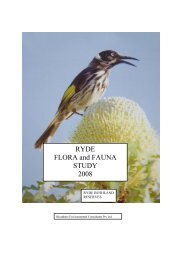
RYDE FLORA and FAUNA STUDY 2007 - City of Ryde - NSW ...
RYDE FLORA and FAUNA STUDY 2007 - City of Ryde - NSW ...
RYDE FLORA and FAUNA STUDY 2007 - City of Ryde - NSW ...

You also want an ePaper? Increase the reach of your titles
YUMPU automatically turns print PDFs into web optimized ePapers that Google loves.
2.0 Introduction<br />
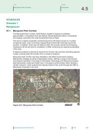
2.1 Background<br />
Biosphere Environmental Consultants Pty Ltd<br />
<strong>Ryde</strong> Flora <strong>and</strong> Fauna Survey <strong>2007</strong> 7<br />
<strong>Ryde</strong> Local Government Area (LGA) contains highly valued bushl<strong>and</strong>. The retention<br />
<strong>of</strong> these bushl<strong>and</strong> areas came about as the result <strong>of</strong> complicated patterns <strong>of</strong> l<strong>and</strong><br />
settlement, difficulties with site access <strong>and</strong> the establishment <strong>of</strong> public utility<br />
easements, <strong>and</strong> not because <strong>of</strong> long-term conservation planning by the early city<br />
founders. However, regardless <strong>of</strong> the mechanism for the establishment <strong>of</strong> the reserves,<br />
the bushl<strong>and</strong> areas have become an important component <strong>of</strong> the <strong>Ryde</strong> l<strong>and</strong>scape.<br />
Urbanisation<br />
Urban development did not occur at uniform rates around Sydney Harbour. Areas<br />
south <strong>of</strong> Port Jackson were inhabited first because the l<strong>and</strong> on the south side <strong>of</strong> the<br />
harbour was flatter <strong>and</strong> appeared to be more fertile (Watkin Tench, 1789). Bridges<br />
between the northern <strong>and</strong> southern sides <strong>of</strong> the harbour were not constructed until the<br />
1930s <strong>and</strong> so l<strong>and</strong> clearing north <strong>of</strong> harbour was less extensive.<br />
With the construction <strong>of</strong> the Sydney Harbour Bridge in 1933, the North Shore area<br />
became the focus <strong>of</strong> rapid urban development. Few farms had been established as<br />
fertile l<strong>and</strong> was confined to a few narrow valleys. A road link to the Hawkesbury<br />
River was established along the ridge top that ran between Middle Harbour <strong>and</strong> the<br />
Lane Cove River valley. This ridge eventually became the route for the Pacific<br />
Highway.<br />
Access to the <strong>Ryde</strong> area was difficult as it was bounded by the Lane Cove River to the<br />
east <strong>and</strong> the Parramatta River to the south. The Hornsby Plateau slopes steeply<br />
southwest into the <strong>Ryde</strong> area again making passage uncomfortable. The easiest means<br />
<strong>of</strong> entry was by boat along the Parramatta River or by l<strong>and</strong> from Parramatta.<br />
Eventually punts were established to provide crossing points across the Parramatta<br />
River <strong>and</strong> it was only then that road networks were established throughout the area.<br />
Initially only river flat areas were opened up for agriculture but orchards <strong>and</strong> other<br />
small scale farms were established in the valley areas. Agriculture was not to remain<br />
as the dominant l<strong>and</strong> use for long. The dem<strong>and</strong> for l<strong>and</strong> for housing soon outstripped<br />
acreages required for farming <strong>and</strong> <strong>Ryde</strong> quickly adopted the heavily-urbanised<br />
features that it still retains. The surge <strong>of</strong> residential dwellings put great pressure on the<br />
supply <strong>of</strong> l<strong>and</strong> <strong>and</strong> all l<strong>and</strong> that was not in very rugged or inaccessible locations was<br />
converted to residential sites or roads.<br />
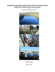
Remnant Bushl<strong>and</strong><br />
For <strong>Ryde</strong>, urbanisation has meant that all <strong>of</strong> the higher ridge areas were cleared <strong>and</strong><br />
settled. Major roads were located at the peak <strong>of</strong> ridges <strong>and</strong> smaller, lateral roads<br />
branched from the main thoroughfares to lower levels. Very little <strong>of</strong> the original<br />
ridge-top vegetation survived l<strong>and</strong> clearing (Howell <strong>and</strong> Benson, 2000). Fortunately,<br />
several areas <strong>of</strong> gully vegetation were not overtaken by the urban sprawl <strong>and</strong> these<br />
remain as green oases in a sea <strong>of</strong> bricks, tar <strong>and</strong> cement.