

the richtersveld cultural and botanical landscape - SAHRA
the richtersveld cultural and botanical landscape - SAHRA
the richtersveld cultural and botanical landscape - SAHRA

You also want an ePaper? Increase the reach of your titles
YUMPU automatically turns print PDFs into web optimized ePapers that Google loves.
Richtersveld Cultural <strong>and</strong> Botanical L<strong>and</strong>scape World Heritage Site Nomination 25<br />
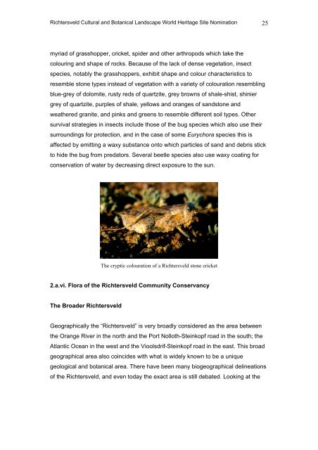
myriad of grasshopper, cricket, spider <strong>and</strong> o<strong>the</strong>r arthropods which take <strong>the</strong><br />
colouring <strong>and</strong> shape of rocks. Because of <strong>the</strong> lack of dense vegetation, insect<br />
species, notably <strong>the</strong> grasshoppers, exhibit shape <strong>and</strong> colour characteristics to<br />
resemble stone types instead of vegetation with a variety of colouration resembling<br />
blue-grey of dolomite, rusty reds of quartzite, grey browns of shale-shist, shinier<br />
grey of quartzite, purples of shale, yellows <strong>and</strong> oranges of s<strong>and</strong>stone <strong>and</strong><br />
wea<strong>the</strong>red granite, <strong>and</strong> pinks <strong>and</strong> greens to resemble different soil types. O<strong>the</strong>r<br />
survival strategies in insects include those of <strong>the</strong> bug species which also use <strong>the</strong>ir<br />
surroundings for protection, <strong>and</strong> in <strong>the</strong> case of some Eurychora species this is<br />
affected by emitting a waxy substance onto which particles of s<strong>and</strong> <strong>and</strong> debris stick<br />
to hide <strong>the</strong> bug from predators. Several beetle species also use waxy coating for<br />
conservation of water by decreasing direct exposure to <strong>the</strong> sun.<br />
The cryptic colouration of a Richtersveld stone cricket<br />
2.a.vi. Flora of <strong>the</strong> Richtersveld Community Conservancy<br />
The Broader Richtersveld<br />
Geographically <strong>the</strong> “Richtersveld” is very broadly considered as <strong>the</strong> area between<br />
<strong>the</strong> Orange River in <strong>the</strong> north <strong>and</strong> <strong>the</strong> Port Nolloth-Steinkopf road in <strong>the</strong> south; <strong>the</strong><br />
Atlantic Ocean in <strong>the</strong> west <strong>and</strong> <strong>the</strong> Vioolsdrif-Steinkopf road in <strong>the</strong> east. This broad<br />
geographical area also coincides with what is widely known to be a unique<br />
geological <strong>and</strong> <strong>botanical</strong> area. There have been many biogeographical delineations<br />
of <strong>the</strong> Richtersveld, <strong>and</strong> even today <strong>the</strong> exact area is still debated. Looking at <strong>the</strong>


