West Babine Sustainable Resource Management Plan
West Babine Sustainable Resource Management Plan
West Babine Sustainable Resource Management Plan

Create successful ePaper yourself
Turn your PDF publications into a flip-book with our unique Google optimized e-Paper software.
Xsu gwin lik’l’inswx: <strong>West</strong> <strong>Babine</strong> <strong>Sustainable</strong> <strong>Resource</strong> <strong>Management</strong> <strong>Plan</strong><br />
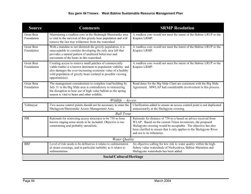
Source Comments SRMP Resolution<br />
Great Bear<br />
Foundation<br />
Great Bear<br />
Foundation<br />
Great Bear<br />
Foundation<br />
Great Bear<br />
Foundation<br />
Maintaining a roadless core in the Shahnagh-Shenismike area<br />
is vital to the survival of this grizzly bear population and will<br />
remove the last true wilderness from the watershed.<br />
With a mandate to not diminish the grizzly population, it is<br />
unacceptable to consider developing the only area left that<br />
provides a natural pattern of unaltered behaviour and<br />
movement of the bears in this watershed.<br />
Creating access to remove small patches of commercially<br />
viable timber is a known detriment to population viability and<br />
also damages the ever-increasing economic value of a healthy<br />
wild population of grizzly bears (related to possible viewing<br />
opportunities).<br />
The management consideration to complete road building by<br />
July 31 in the Big Slide area is contradictory to minimizing<br />
the disruption to bear use of high value habitat as the spring<br />
season is vital to bears and other wildlife.<br />
Wildlife – Access<br />
Veltmeyer Two access control points should not be necessary to enter the<br />
Shelagyote/Shenismike Access <strong>Management</strong> Area.<br />
Bull Trout<br />
PIR Rationale for restricting access structures to be 750 m from<br />
known staging areas needs to be included. Objective is too<br />
constraining and probably unrealistic.<br />
Water Quality<br />
BRF Level of risk needs to be defined as it relates to sedimentation<br />
at steam crossings, and in particular turbidity as it relates to<br />
sedimentation.<br />
Social/Cultural/Heritage<br />
Page 94 March 2004<br />
A roadless core would not meet the intent of the <strong>Babine</strong> LRUP or the<br />
Kispiox LRMP.<br />
A roadless core would not meet the intent of the <strong>Babine</strong> LRUP or the<br />
Kispiox LRMP.<br />
A roadless core would not meet the intent of the <strong>Babine</strong> LRUP or the<br />
Kispiox LRMP.<br />
Road dates for the Big Slide Chart are consistent with the Big Slide<br />
Agreement. MWLAP had considerable involvement in this process.<br />
Clarification added to ensure an access control point is not duplicated<br />
unnecessarily at the Shelagyote crossing.<br />
Rationale for distance of 750 m is based on advice received from<br />
WLAP. Based on the current Triton inventories, the proposed<br />
Shelagyote crossing would be acceptable. The objective has also<br />
been clarified to ensure that it only applies to the Shelagyote River<br />
and not to its tributaries.<br />
An objective calling for low risk to water quality within the highfishery<br />
value watersheds of Nichyeskwa, <strong>Babine</strong> Mainstem and<br />
Shelagyote watersheds has been added.