West Babine Sustainable Resource Management Plan
West Babine Sustainable Resource Management Plan
West Babine Sustainable Resource Management Plan

You also want an ePaper? Increase the reach of your titles
YUMPU automatically turns print PDFs into web optimized ePapers that Google loves.
Water quality is one of the primary interests expressed by the Gitxsan First Nation and<br />
stakeholders. Water quality tends to be most influenced by forestry activities related to road<br />
layout, construction, maintenance and deactivation. MSRM has assessed the implications of<br />
timber harvesting on water quality and quantity, given the other management strategies that are<br />
in place for the area. Generally speaking the <strong>West</strong> <strong>Babine</strong> plan area is at a low risk for<br />
harvesting-related hydrological instability (i.e., changes to peak or low flows) due to its<br />
relatively small amount of operable forest. In addition, objectives to maintain biodiversity, visual<br />
quality, and grizzly bear habitat limits the amount of timber harvesting that can occur in a given<br />
watershed. In the Gail, Shedin and Shelagyote watersheds where the majority of snow pack<br />
accumulates above the operable landbase, and in the <strong>Babine</strong> watershed where a large portion of<br />
the forested area is within the park, clearcutting will have a minimal impact on peak flows and<br />
hydrological integrity.<br />
<strong>Management</strong> direction to maintain water quality and hydrological integrity<br />
The Kispiox LRMP includes the following objective for hydrological integrity:<br />
to protect the hydrological integrity of watersheds.<br />
A strategy of the LRMP, which is to be refined at the landscape planning level is: on average no<br />
more than 22 per cent of the forested land in a watershed will be in a hydrological condition<br />
equivalent to clearcut (ECA). The recommended ECAs by watershed in Table 10, page 34 are<br />
based on assessments by hydrologists in Prince Rupert Forest Region, and replace the 22 per cent<br />
“rule-of-thumb average.<br />
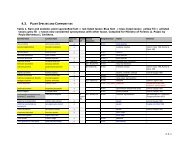
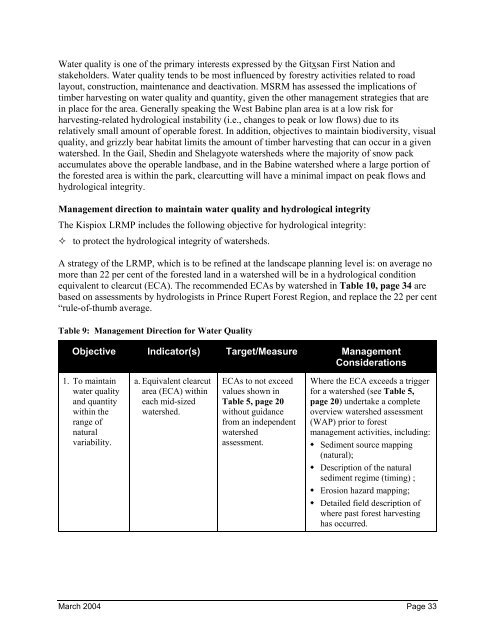
Table 9: <strong>Management</strong> Direction for Water Quality<br />
Objective Indicator(s) Target/Measure <strong>Management</strong><br />
Considerations<br />
1. To maintain<br />
water quality<br />
and quantity<br />
within the<br />
range of<br />
natural<br />
variability.<br />
a. Equivalent clearcut<br />
area (ECA) within<br />
each mid-sized<br />
watershed.<br />
ECAs to not exceed<br />
values shown in<br />
Table 5, page 20<br />
without guidance<br />
from an independent<br />
watershed<br />
assessment.<br />
Where the ECA exceeds a trigger<br />
for a watershed (see Table 5,<br />
page 20) undertake a complete<br />
overview watershed assessment<br />
(WAP) prior to forest<br />
management activities, including:<br />
Sediment source mapping<br />
(natural);<br />
Description of the natural<br />
sediment regime (timing) ;<br />
Erosion hazard mapping;<br />
Detailed field description of<br />
where past forest harvesting<br />
has occurred.<br />
March 2004 Page 33