West Babine Sustainable Resource Management Plan
West Babine Sustainable Resource Management Plan
West Babine Sustainable Resource Management Plan

Create successful ePaper yourself
Turn your PDF publications into a flip-book with our unique Google optimized e-Paper software.
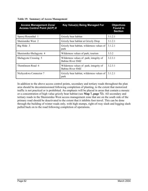
Table 19: Summary of Access <strong>Management</strong><br />
Access <strong>Management</strong> Zone/<br />
Access Control Point (ACP) #<br />
Key Value(s) Being Managed For Objectives<br />
Found in<br />
Section<br />
Sperry/Rosenthal 1 Grizzly bear habitat 3.1.2.1<br />
Shenismike <strong>West</strong> 2 Grizzly bear habitat at Grizzly Drop 3.1.2.1<br />
Big Slide 3 Grizzly bear habitat, wilderness values of<br />
park<br />
3.1.2.1<br />
Shenismike-Shelagyote 4 Wilderness values of park; tourism 3.3.2<br />
Shelagyote Crossing 5 Wilderness values of park; integrity of<br />
<strong>Babine</strong> River SMZ<br />
Thomlinson Road 6 Wilderness values of park; integrity of<br />
<strong>Babine</strong> River SMZ<br />
Nichyeskwa Connector 7 Grizzly bear habitat, wilderness values of<br />
park<br />
3.2.3.1<br />
3.2.3.1<br />
3.1.2.1<br />
In addition to the above access control points, secondary and tertiary roads throughout the plan<br />
area should be decommissioned following completion of planting, to the extent that motorized<br />
traffic is not practical or is prohibited. An emphasis will be placed in areas that contain a mosaic<br />
or a concentration of high value grizzly bear habitat (see Map 7, page 72). All secondary and<br />
tertiary roads in the Shenismike-<strong>West</strong> access management zone that are on the south side of the<br />
primary road should be deactivated to the extent that it inhibits foot travel. This can be done<br />
through the building of winter roads only, with high stumps, right-of-way slash and logging slash<br />
pulled back on to the road following completion of operations.<br />
Page 62 March 2004