Proceedings - Johannes Gutenberg-Universität Mainz
Proceedings - Johannes Gutenberg-Universität Mainz
Proceedings - Johannes Gutenberg-Universität Mainz

You also want an ePaper? Increase the reach of your titles
YUMPU automatically turns print PDFs into web optimized ePapers that Google loves.
2 nd INQUA-IGCP-567 International Workshop on Active Tectonics, Earthquake Geology, Archaeology and Engineering, Corinth, Greece (2011)<br />
EARTHQUAKE<br />
ARCHAEOLOGY<br />
INQUA PALEOSEISMOLOGY<br />
AND ACTIVE TECTONICS<br />
we could not find any channel deposits in test<br />
trenches and it was thus impossible to find linear<br />
features that could account for lateral offsetting. In<br />
further developments, we thus used the<br />
“morphological slip vector” of Winter et al. (1993).<br />
In the three excavated trenches, ash falls are<br />
strongly pedogenetized in black organic soils<br />
(andisols), over thicknesses of 2 to 3.5 meters.<br />
last event in 1797 should then have a higher<br />
magnitude than mentioned in table 1. Moreover, the<br />
event #2, which is also recorded in trench #1 and<br />
well constrained by 14 C datings, is associated with 2<br />
successive and discordant colluvial wedges. If we<br />
assume this is not partly due to non-tectonic<br />
processes (climate degradation for ex.), then arises<br />
the issue of possible under-representation of<br />
earthquake number in trench #2 (and correlative<br />
overestimation of magnitude).<br />
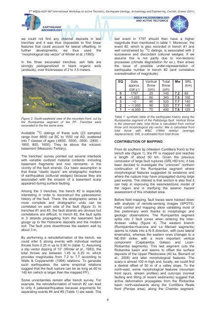
Trenches<br />
#1<br />
#2 & 3<br />
Fault trace<br />
EQ<br />
Date<br />
approx.<br />
(cal y.)<br />
Vertical<br />
throw<br />
(cm)<br />
Total<br />
throw<br />
(cm)<br />
Mw<br />
SRL<br />
(km)<br />
5 1797 25 145 7.2 60<br />
4 ~1,000 60 345 7.5 100<br />
3 ~0 90 520 7.7 140<br />
2 ~ -1,000 90 520 7.7 140<br />
1 ~ -4,500 70 400 7.6 120<br />
Figure 2: South-eastward view of the mountain front, cut by<br />
the Rumipamba segment of the PF. Trenches were<br />
excavated in the the same area.<br />
Available 14 C datings of these soils (23 samples)<br />
range from 6650 cal BC to 1650 cal AD, scattered<br />
into 7 classes of ages (-6650, -5500, -3500, -2800, -<br />
1800, 800, 1650). They lie above the volcanic<br />
basement (Mesozoic-Tertiary).<br />
The trenches’ survey pointed out several interbeds<br />
with variable oxidized material contents -including<br />
basement fragments and root remnants- in the<br />
vicinity of the fault strands. Our basic assumption is<br />
that these “clastic layers” are stratigraphic markers<br />
of earthquakes (colluvial wedges) because they are<br />
associated with the erosion of a basement scarp<br />
appeared during surface faulting.<br />
Among the 3 trenches, the trench #2 is especially<br />
interesting in order to reconstruct the paleoseismic<br />
history of the fault. There, the stratigraphic series is<br />
more complete and stratigraphic units can be<br />
correlated on each side of the fault (figure 3). In<br />
trenches #1 and #3, the fault strands are obvious but<br />
correlations are difficult. In trench #2, the fault splits<br />
in 3 strands propagating from the basement fault<br />
gouge up to the Holocene deposits and the modern<br />
soil. The fault zone downthrows the eastern wall by<br />
about 3 m.<br />
By performing a retrodeformation of the trench, we<br />
could infer 5 strong events with individual vertical<br />
throws from 0.25 m up to 0.90 m (table 1). Assuming<br />
a slip vector dipping of 10° (Winter et al., 1993), the<br />
total throws are between 1.45 to 5.20 m, which<br />
provides magnitudes from 7.2 to 7.7 according to<br />
Wells & Coppersmith (1994) relations. To generate<br />
such earthquakes, the same empirical relations<br />
suggest that the fault rupture can be as long as 60 to<br />
140 km (which is larger than the mapped PF).<br />
Some uncertainties remain after trench survey. For<br />
example, the retrodeformation of trench #2 can lead<br />
to only 4 paleoearthquakes because arguments for<br />
separating events #4 and #5 (Table 1) are weak. The<br />
Table 1: synthetic table of the earthquake history along the<br />
Rumipamba segment of the Pallatanga fault. Vertical throw<br />
is the observed data; total throw is calculated from vertical<br />
throw and morphological slip vector; Mw is calculated from<br />
total throw with W&C (1994) relation (average<br />
displacement); SRL is estimated from total throw<br />
CONTRIBUTION OF MAPPING<br />
From its southern tip (Western Cordillera front) to the<br />
trench site (figure 1), the PF is mapped and reaches<br />
a length of about 60 km. Given the previous<br />
conclusion of large fault ruptures (SRL>60 km), it has<br />
been decided to investigate the “unknown” northern<br />
continuation of the Rumipamba segment where<br />
morphological features suggested its existence and<br />
where the rupture may have propagated during large<br />
past events. The interest is that section is also that it<br />
can help in improving the seismotectonic model of<br />
the region and in clarifying the seismic hazard<br />
assessment of this inhabited area.<br />
Before field mapping, fault traces were tracked down<br />
with analysis of remote-sensing images (SPOT5).<br />
Field control and mapping allow validating most of<br />
this preliminary work thanks to morphologic and<br />
geologic observations. The Rumipamba segment<br />
splits into 2 fault zones when entering the Inter-<br />
Andean valley (figure 4). The western branch<br />
(Rumipamba-Huacona and La Merced segments)<br />
seems to rotate into a N-S direction, with pure lateral<br />
kinematics, whereas the eastern ones changes to a<br />
NE-SW strike, with a more important vertical<br />
component (Cajabamba, Gatazo and Lican-<br />
Riobamba segments). This last segment cuts the<br />
Riobamba basin and seems to offset the surface<br />
deposits of the Upper Pleistocene (40 ka, Bernard et<br />
al., 2008) and later morphological features. The<br />
scarp is almost 100 m high and, locally, we could find<br />
a dextral offset of 50 m of a valley slope. To the<br />
north-east, some morphological features (mountain<br />
front spurs, stream profiles) and outcrops (normal<br />
faulting and tilting of recent sediments) suggest that<br />
active deformation propagates from the Riobamba<br />
basin north-eastwards along the Cordillera Reale<br />
front (Penipe area), along the Chambo segment.<br />
4