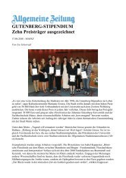
Proceedings - Johannes Gutenberg-Universität Mainz
Proceedings - Johannes Gutenberg-Universität Mainz
Proceedings - Johannes Gutenberg-Universität Mainz

Create successful ePaper yourself
Turn your PDF publications into a flip-book with our unique Google optimized e-Paper software.
2 nd INQUA-IGCP-567 International Workshop on Active Tectonics, Earthquake Geology, Archaeology and Engineering, Corinth, Greece (2011)<br />
EARTHQUAKE<br />
ARCHAEOLOGY<br />
INQUA PALEOSEISMOLOGY<br />
AND ACTIVE TECTONICS<br />
THE DISCONTINUITY OF A CONTINUOUS FAULT: DELPHI (GREECE)<br />
Wiatr, Thomas (1), Klaus Reicherter (1), Ioannis D. Papanikolau (2, 3) & Tomás Fernández-Steeger (4)<br />
(1) RWTH Aachen University, Neotectonics and Natural Hazards Group, Lochnerstr. 4-20, 52056 Aachen, Germany<br />
(2) Laboratory of Mineralogy & Geology, Department of Sciences, Agricultural University of Athens, 75 Iera Odos Str., 11855<br />
Athens, Greece. papanikolaou@ucl.ac.uk<br />
(3) AON Benfield UCL Hazard Research Centre, Department of Earth Sciences, University College London, WC 1E 6BT,<br />
London UK. papanikolaou@ucl.ac.uk<br />
(4) RWTH Aachen University, Department of Engineering Geology and Hydrogeology, Lochnerstr. 4-20, 52064 Aachen,<br />
Germany. fernandez-steeger@lih.rwth-aachen.de<br />
Abstract (The discontinuity of a continuous fault: Delphi (Greece): We used a terrestrial laser scanning system for the<br />
reconstruction and analysis of the morphotectonic features on a fault segment near the ancient Delphi, Greece. Delphi is located<br />
on the northern part of the Gulf of Corinth and embedded in a seismic landscape and is the major onshore fault north of the<br />
Corinth Gulf. This paper concentrates on the LiDAR long range investigation of the fault for generating a digital elevation model.<br />
The model was used for estimating the natural fault plane height by using several vertical profiles. The results show a high<br />
horizontal and vertical variability on a 120 m long fault scarp.<br />
Key words: long range LiDAR, discontinuous fault, Corinth Gulf, Delphi<br />
INTRODUCTION<br />
The ancient Delphi with its oracle dedicated to the<br />
god Apollo, was the most popular place of worship<br />
around 700 B.C. to 400 A.D. in ancient Greece.<br />
Delphi is located at the southern flank of Mount<br />
Parnassus that is compiled by thick-bedded neritic<br />
Mesozoic limestones with significant bauxite<br />
deposits. The mountain range is situated on the<br />
northern coast of the Gulf of Corinth and bounded by<br />
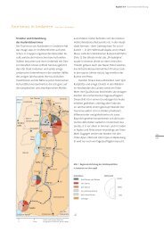
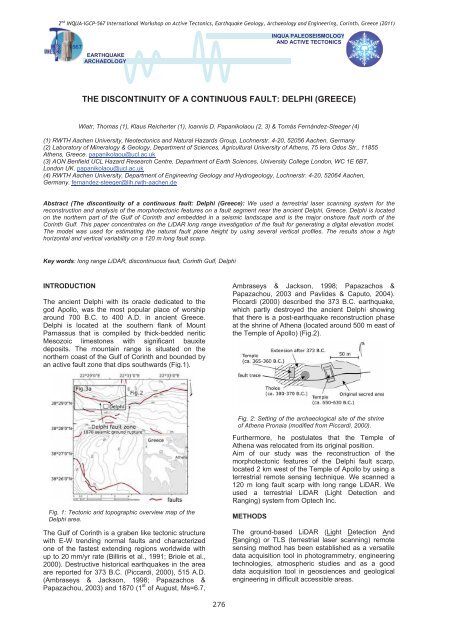
an active fault zone that dips southwards (Fig.1).<br />
Ambraseys & Jackson, 1998; Papazachos &<br />
Papazachou, 2003 and Pavlides & Caputo, 2004).<br />
Piccardi (2000) described the 373 B.C. earthquake,<br />
which partly destroyed the ancient Delphi showing<br />
that there is a post-earthquake reconstruction phase<br />
at the shrine of Athena (located around 500 m east of<br />
the Temple of Apollo) (Fig.2).<br />
Fig. 2: Setting of the archaeological site of the shrine<br />
of Athena Pronaia (modified from Piccardi, 2000).<br />
Fig. 1: Tectonic and topographic overview map of the<br />
Delphi area.<br />
The Gulf of Corinth is a graben like tectonic structure<br />
with E-W trending normal faults and characterized<br />
one of the fastest extending regions worldwide with<br />
up to 20 mm/yr rate (Billiris et al., 1991; Briole et al.,<br />
2000). Destructive historical earthquakes in the area<br />
are reported for 373 B.C. (Piccardi, 2000), 515 A.D.<br />
(Ambraseys & Jackson, 1998; Papazachos &<br />
Papazachou, 2003) and 1870 (1 st of August, Ms=6.7,<br />
Furthermore, he postulates that the Temple of<br />
Athena was relocated from its original position.<br />
Aim of our study was the reconstruction of the<br />
morphotectonic features of the Delphi fault scarp,<br />
located 2 km west of the Temple of Apollo by using a<br />
terrestrial remote sensing technique. We scanned a<br />
120 m long fault scarp with long range LiDAR. We<br />
used a terrestrial LiDAR (Light Detection and<br />
Ranging) system from Optech Inc.<br />
METHODS<br />
The ground-based LiDAR (Light Detection And<br />
Ranging) or TLS (terrestrial laser scanning) remote<br />
sensing method has been established as a versatile<br />
data acquisition tool in photogrammetry, engineering<br />
technologies, atmospheric studies and as a good<br />
data acquisition tool in geosciences and geological<br />
engineering in difficult accessible areas.<br />
276