Proceedings - Johannes Gutenberg-Universität Mainz
Proceedings - Johannes Gutenberg-Universität Mainz
Proceedings - Johannes Gutenberg-Universität Mainz

You also want an ePaper? Increase the reach of your titles
YUMPU automatically turns print PDFs into web optimized ePapers that Google loves.
2 nd INQUA-IGCP-567 International Workshop on Active Tectonics, Earthquake Geology, Archaeology and Engineering, Corinth, Greece (2011)<br />
EARTHQUAKE<br />
ARCHAEOLOGY<br />
INQUA PALEOSEISMOLOGY<br />
AND ACTIVE TECTONICS<br />
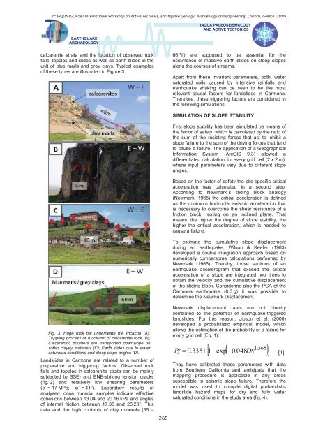
calcarenite strata and the location of observed rock<br />
falls, topples and slides as well as earth slides in the<br />
unit of blue marls and grey clays. Typical examples<br />
of these types are illustrated in Figure 3.<br />
66 %) are supposed to be essential for the<br />
occurrence of massive earth slides on steep slopes<br />
along the courses of streams.<br />
Apart from these invariant parameters, both, water<br />
saturated soils caused by intensive rainfalls and<br />
earthquake shaking can be seen to be the most<br />
relevant causal factors for landslides in Carmona.<br />
Therefore, these triggering factors are considered in<br />
the following simulations.<br />
Fig. 3: Huge rock fall underneath the Picacho (A);<br />
Toppling process of a column of calcarenite rock (B);<br />
Calcarenitic boulders are transported downslope on<br />
softer clayey materials (C); Earth slides due to water<br />
saturated conditions and steep slope angles (D).<br />
Landslides in Carmona are related to a number of<br />
preparative and triggering factors. Observed rock<br />
falls and topples in calcarenite strata can be mainly<br />
subjected to SSE- and ENE-striking tension cracks<br />
(fig. 2) and relatively low shearing parameters<br />
(c´ = 17 MPa; ´ = 41°). Laboratory results of<br />
analysed loose material samples indicate effective<br />
cohesions between 13.04 and 20.16 kPa and angles<br />
of internal friction between 17.35 and 26.23°. This<br />
data and the high contents of clay minerals (35 –<br />
265<br />
SIMULATION OF SLOPE STABILITY<br />
First slope stability has been simulated be means of<br />
the factor of safety, which is calculated by the ratio of<br />
the sum of the resisting forces that act to inhibit a<br />
slope failure to the sum of the driving forces that tend<br />
to cause a failure. The application of a Geographical<br />
Information System (ArcGIS 9.3) allowed a<br />
differentiated calculation for every grid cell (2 x 2 m),<br />
where input parameters vary due to different slope<br />
angles.<br />
Based on the factor of safety the site-specific critical<br />
acceleration was calculated in a second step.<br />
According to Newmark´s sliding block analogy<br />
(Newmark, 1965) the critical acceleration is defined<br />
as the minimum horizontal seismic acceleration that<br />
is necessary to overcome the shear resistance of a<br />
friction block, resting on an inclined plane. That<br />
means, the higher the degree of slope stability, the<br />
higher the critical acceleration, which is needed to<br />
cause a failure.<br />
To estimate the cumulative slope displacement<br />
during an earthquake, Wilson & Keefer (1983)<br />
developed a double integration approach based on<br />
numerically cumbersome calculations performed by<br />
Newmark (1965). Thereby, those sections of an<br />
earthquake accelerogram that exceed the critical<br />
acceleration of a slope are integrated two times to<br />
obtain the velocity and the cumulative displacement<br />
of the sliding block. Considering also the PGA of the<br />
Carmona earthquake (0.3 g) it was possible to<br />
determine the Newmark Displacement.<br />
Newmark displacement rates are not directly<br />
correlated to the potential of earthquake-triggered<br />
landslides. For this reason, Jibson et al. (2000)<br />
developed a probabilistic empirical model, which<br />
allows the estimation of the probability of a failure for<br />
every grid cell (Eq. 1):<br />
P<br />
<br />
<br />
<br />
1.565<br />
f 0.335<br />
1exp0.048D<br />
N [1]<br />
They have calibrated these parameters with data<br />
from Southern California and anticipate that the<br />
mapping procedure is applicable in any areas<br />
susceptible to seismic slope failure. Therefore the<br />
model was used to compile digital probabilistic<br />
landslide hazard maps for dry and fully water<br />
saturated conditions in the study area (fig. 4).