Proceedings - Johannes Gutenberg-Universität Mainz
Proceedings - Johannes Gutenberg-Universität Mainz
Proceedings - Johannes Gutenberg-Universität Mainz

You also want an ePaper? Increase the reach of your titles
YUMPU automatically turns print PDFs into web optimized ePapers that Google loves.
2 nd INQUA-IGCP-567 International Workshop on Active Tectonics, Earthquake Geology, Archaeology and Engineering, Corinth, Greece (2011)<br />
EARTHQUAKE<br />
ARCHAEOLOGY<br />
INQUA PALEOSEISMOLOGY<br />
AND ACTIVE TECTONICS<br />
STRAIN RATES<br />
In order to provide results independent from the<br />
choice of the reference frame, strain analysis was<br />
performed by the grid_strain Matlab TM software<br />
package (Teza et al., 2008). It allows the definition of<br />
the deformation pattern by providing the intensity and<br />
direction of principal components of strain tensor<br />
together with corresponding errors, by means of a<br />
modified linear least-squares (LS) inversion, under<br />
the hypothesis of uniform strain field condition. Inputs<br />
for calculating strain were horizontal GPS annual<br />
velocities and their corresponding errors. In this<br />
sense results express the linear strain rates in the<br />
region.<br />
For the purpose of the analysis, GPS sites located on<br />
the mountains bordering the Athens Basin,<br />
specifically on the metamorphic basement of Pendeli<br />
and Hymettus mountains to the East (APR, ARG,<br />
HYM, NER and TAT) and on the non-metamorphic<br />
formations of eastern Parnitha Mt. and Aegaleo Mt.<br />
(E067, CHS, KOR, PKL and PRM) were selected.<br />
The analysis involved initially the calculation of a<br />
single strain tensor based on all selected stations<br />
and then, by gradual segmentation of the area for a<br />
more detailed investigation of spatial variations of the<br />
deformation regime. All calculations are referred to<br />
the center of mass of each set of sites considered.<br />
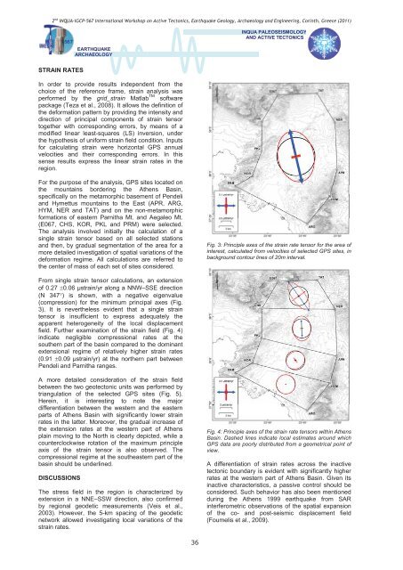
Fig. 3: Principle axes of the strain rate tensor for the area of<br />
interest, calculated from velocities of selected GPS sites, in<br />
background contour lines of 20m interval.<br />
From single strain tensor calculations, an extension<br />
of 0.27 0.06 strain/yr along a NNW–SSE direction<br />
(N 347) is shown, with a negative eigenvalue<br />
(compression) for the minimum principal axes (Fig.<br />
3). It is nevertheless evident that a single strain<br />
tensor is insufficient to express adequately the<br />
apparent heterogeneity of the local displacement<br />
field. Further examination of the strain field (Fig. 4)<br />
indicate negligible compressional rates at the<br />
southern part of the basin compared to the dominant<br />
extensional regime of relatively higher strain rates<br />
(0.91 0.09 strain/yr) at the northern part between<br />
Pendeli and Parnitha ranges.<br />
A more detailed consideration of the strain field<br />
between the two geotectonic units was performed by<br />
triangulation of the selected GPS sites (Fig. 5).<br />
Herein, it is interesting to note the major<br />
differentiation between the western and the eastern<br />
parts of Athens Basin with significantly lower strain<br />
rates in the latter. Moreover, the gradual increase of<br />
the extension rates at the western part of Athens<br />
plain moving to the North is clearly depicted, while a<br />
counterclockwise rotation of the maximum principle<br />
axis of the strain tensor is also observed. The<br />
compressional regime at the southeastern part of the<br />
basin should be underlined.<br />
DISCUSSIONS<br />
The stress field in the region is characterized by<br />
extension in a NNE–SSW direction, also confirmed<br />
by regional geodetic measurements (Veis et al.,<br />
2003). However, the 5-km spacing of the geodetic<br />
network allowed investigating local variations of the<br />
strain rates.<br />
Fig. 4: Principle axes of the strain rate tensors within Athens<br />
Basin. Dashed lines indicate local estimates around which<br />
GPS data are poorly distributed from a geometrical point of<br />
view.<br />
A differentiation of strain rates across the inactive<br />
tectonic boundary is evident with significantly higher<br />
rates at the western part of Athens Basin. Given its<br />
inactive characteristics, a passive control should be<br />
considered. Such behavior has also been mentioned<br />
during the Athens 1999 earthquake from SAR<br />
interferometric observations of the spatial expansion<br />
of the co- and post-seismic displacement field<br />
(Foumelis et al., 2009).<br />
36