Proceedings - Johannes Gutenberg-Universität Mainz
Proceedings - Johannes Gutenberg-Universität Mainz
Proceedings - Johannes Gutenberg-Universität Mainz

You also want an ePaper? Increase the reach of your titles
YUMPU automatically turns print PDFs into web optimized ePapers that Google loves.
2 nd INQUA-IGCP-567 International Workshop on Active Tectonics, Earthquake Geology, Archaeology and Engineering, Corinth, Greece (2011)<br />
EARTHQUAKE<br />
ARCHAEOLOGY<br />
INQUA PALEOSEISMOLOGY<br />
AND ACTIVE TECTONICS<br />
PLIO – PLEISTOCENE TECTONIC ACTIVITY IN THE SOUTHWEST OF PORTUGAL<br />
Figueiredo, Paula M. (1, 2), Cabral, João (1,2), Rockwell, Thomas K. (3)<br />
(1) IDL, Instituto Dom Luiz, pmfigueiredo@fc.ul.pt<br />
(2) Geology Department, Science Faculty, Lisbon University<br />
(3) Geological Department, San Diego State University<br />
Abstract: Southwest Portugal, located close to the Eurasia-Núbia plate boundary, is characterized by moderate<br />
seismicity, although strong events may occur, as in 1755 (Mw8), 1969, (Mw 7.9), and more recently in 2007 (Mw<br />
6.3) and 2009 (Mw 6.1), all located in the offshore. No historical earthquakes with onshore rupture are known for<br />
this region. Inland, recent neotectonic and paleoseismological studies corroborate seismogenic activity during the<br />
Pleistocene, at the S.Teotónio–Aljezur–Sinceira Fault System, suggesting that these structures are active and are<br />
potential sources for moderate seismicity. At the coastline, several features such as old beach sediments, paleo<br />
abrasion platforms and paleo cliffs were recognized. A sequence of poorly preserved surfaces with thin deposits<br />
may correspond to Pleistocene marine terraces, suggesting a higher uplift rate than expected for this region.<br />
Key words: Pleistocene, Uplift, active tectonics, Portugal<br />
INTRODUCTION<br />
Southwestern Portugal is located close to the<br />
Eurasia-Nubia plate boundary, near the Azores-<br />
Gibraltar fracture zone. East of the Gloria transform<br />
fault, this boundary becomes complex and diffuse,<br />
where deformation is distributed across a few<br />
hundred kilometres wide zone, related to the NW-SE<br />
convergence of Iberia and Nubia at a rate of ca. 4-5<br />
mm/yr. In this area is located the inferred<br />
seismogenic source zone of the 1755 earthquake<br />
and tsunami (estimated Mw 8), and also of the Mw<br />
7.9 1969 event. (Zittelini et al., 2009).<br />
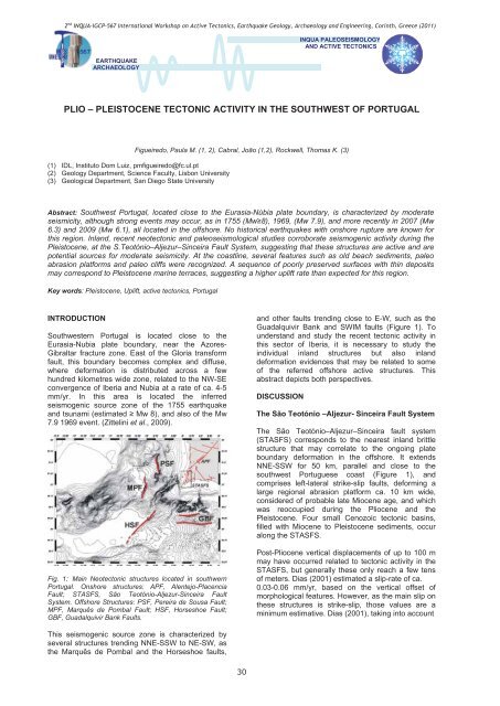
Fig. 1: Main Neotectonic structures located in southwern<br />
Portugal. Onshore structures: APF, Alentejo-Placencia<br />
Fault; STASFS, São Teotónio-Aljezur-Sinceira Fault<br />
System. Offshore Structures: PSF, Pereira de Sousa Fault;<br />
MPF, Marquês de Pombal Fault; HSF, Horseshoe Fault;<br />
GBF, Guadalquivir Bank Faults.<br />
and other faults trending close to E-W, such as the<br />
Guadalquivir Bank and SWIM faults (Figure 1). To<br />
understand and study the recent tectonic activity in<br />
this sector of Iberia, it is necessary to study the<br />
individual inland structures but also inland<br />
deformation evidences that may be related to some<br />
of the referred offshore active structures. This<br />
abstract depicts both perspectives.<br />
DISCUSSION<br />
The São Teotónio –Aljezur- Sinceira Fault System<br />
The São Teotónio–Aljezur–Sinceira fault system<br />
(STASFS) corresponds to the nearest inland brittle<br />
structure that may correlate to the ongoing plate<br />
boundary deformation in the offshore. It extends<br />
NNE-SSW for 50 km, parallel and close to the<br />
southwest Portuguese coast (Figure 1), and<br />
comprises left-lateral strike-slip faults, deforming a<br />
large regional abrasion platform ca. 10 km wide,<br />
considered of probable late Miocene age, and which<br />
was reoccupied during the Pliocene and the<br />
Pleistocene. Four small Cenozoic tectonic basins,<br />
filled with Miocene to Pleistocene sediments, occur<br />
along the STASFS.<br />
Post-Pliocene vertical displacements of up to 100 m<br />
may have occurred related to tectonic activity in the<br />
STASFS, but generally these only reach a few tens<br />
of meters. Dias (2001) estimated a slip-rate of ca.<br />
0.03-0.06 mm/yr, based on the vertical offset of<br />
morphological features. However, as the main slip on<br />
these structures is strike-slip, those values are a<br />
minimum estimative. Dias (2001), taking into account<br />
This seismogenic source zone is characterized by<br />
several structures trending NNE-SSW to NE-SW, as<br />
the Marquês de Pombal and the Horseshoe faults,<br />
30