Proceedings - Johannes Gutenberg-Universität Mainz
Proceedings - Johannes Gutenberg-Universität Mainz
Proceedings - Johannes Gutenberg-Universität Mainz

You also want an ePaper? Increase the reach of your titles
YUMPU automatically turns print PDFs into web optimized ePapers that Google loves.
2 nd INQUA-IGCP-567 International Workshop on Active Tectonics, Earthquake Geology, Archaeology and Engineering, Corinth, Greece (2011)<br />
EARTHQUAKE<br />
ARCHAEOLOGY<br />
INQUA PALEOSEISMOLOGY<br />
AND ACTIVE TECTONICS<br />
datasets, an abundance of geological, morphological<br />
and hydrological factors were used as input data.<br />
The dataset was prepared in a ArcGIS on a pixel<br />
base, while the main modelling was executed with<br />
the PASW Modeler 14 (SPSS Inc.), a user interface<br />
for common data mining algorithms as well as data<br />
pre- and post-processing The results of the<br />
classification were transferred back to the GIS for<br />
evaluation. While the ANN was adjusted quite<br />
optimal to the landslides and provided good<br />
classifications, the Bayesian networks developed the<br />
ability to identify also zones for possible future<br />
landslides. At this point of the work the contribution of<br />
each factor to the result is still not very transparent.<br />
Further development is needed here. Whereas ANNs<br />
have already successfully been implemented for<br />
landslide susceptibility analysis (Fernandez-Steeger,<br />
2002; Lee et al., 2003) there are no studies based on<br />
Bayesian networks. A comparison between the<br />
results of the InfoVal method and a Bayesian network<br />
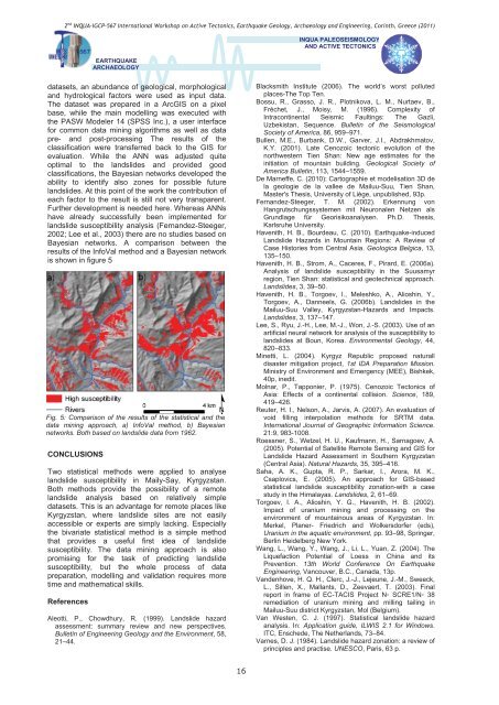
is shown in figure 5<br />
Fig. 5: Comparison of the results of the statistical and the<br />
data mining approach, a) InfoVal method, b) Bayesian<br />
networks. Both based on landslide data from 1962.<br />
CONCLUSIONS<br />
Two statistical methods were applied to analyse<br />
landslide susceptibility in Maily-Say, Kyrgyzstan.<br />
Both methods provide the possibility of a remote<br />
landslide analysis based on relatively simple<br />
datasets. This is an advantage for remote places like<br />
Kyrgyzstan, where landslide sites are not easily<br />
accessible or experts are simply lacking. Especially<br />
the bivariate statistical method is a simple method<br />
that provides a useful first idea of landslide<br />
susceptibility. The data mining approach is also<br />
promising for the task of predicting landslide<br />
susceptibility, but the whole process of data<br />
preparation, modelling and validation requires more<br />
time and mathematical skills.<br />
References<br />
Aleotti, P., Chowdhury, R. (1999). Landslide hazard<br />
assessment: summary review and new perspectives.<br />
Bulletin of Engineering Geology and the Environment, 58,<br />
21–44.<br />
Blacksmith Institute (2006). The world’s worst polluted<br />
places-The Top Ten.<br />
Bossu, R., Grasso, J. R., Plotnikova, L. M., Nurtaev, B.,<br />
Fréchet, J., Moisy, M. (1996). Complexity of<br />
Intracontinental Seismic Faultings: The Gazli,<br />
Uzbekistan, Sequence. Bulletin of the Seismological<br />
Society of America, 86, 959–971.<br />
Bullen, M.E., Burbank, D.W., Garver, J.I., Abdrakhmatov,<br />
K.Y. (2001). Late Cenozoic tectonic evolution of the<br />
northwestern Tien Shan: New age estimates for the<br />
initiation of mountain building. Geological Society of<br />
America Bulletin, 113, 1544–1559.<br />
De Marneffe, C. (2010): Cartographie et modelisation 3D de<br />
la geologie de la vallee de Mailuu-Suu, Tien Shan,<br />
Master's Thesis, University of Liège, unpublished, 93p.<br />
Fernandez-Steeger, T. M. (2002). Erkennung von<br />
Hangrutschungssystemen mit Neuronalen Netzen als<br />
Grundlage für Georisikoanalysen. Ph.D. Thesis,<br />
Karlsruhe University.<br />
Havenith, H. B., Bourdeau, C. (2010). Earthquake-induced<br />
Landslide Hazards in Mountain Regions: A Review of<br />
Case Histories from Central Asia. Geologica Belgica, 13,<br />
135–150.<br />
Havenith, H. B., Strom, A., Caceres, F., Pirard, E. (2006a).<br />
Analysis of landslide susceptibility in the Suusamyr<br />
region, Tien Shan: statistical and geotechnical approach.<br />
Landslides, 3, 39–50.<br />
Havenith, H. B., Torgoev, I., Meleshko, A., Alioshin, Y.,<br />
Torgoev, A., Danneels, G. (2006b). Landslides in the<br />
Mailuu-Suu Valley, Kyrgyzstan-Hazards and Impacts.<br />
Landslides, 3, 137–147.<br />
Lee, S., Ryu, J.-H., Lee, M.-J., Won, J.-S. (2003). Use of an<br />
articial neural network for analysis of the susceptibility to<br />
landslides at Boun, Korea. Environmental Geology, 44,<br />
820–833.<br />
Minetti, L. (2004). Kyrgyz Republic proposed naturall<br />
disaster mitigation project, 1st IDA Preparation Mission.<br />
Ministry of Environment and Emergency (MEE), Bishkek,<br />
40p, inedit.<br />
Molnar, P., Tapponier, P. (1975). Cenozoic Tectonics of<br />
Asia: Effects of a continental collision. Science, 189,<br />
419–426.<br />
Reuter, H. I., Nelson, A., Jarvis, A. (2007). An evaluation of<br />
void filling interpolation methods for SRTM data.<br />
International Journal of Geographic Information Science.<br />
21:9, 983-1008.<br />
Roessner, S., Wetzel, H. U., Kaufmann, H., Sarnagoev, A.<br />
(2005). Potential of Satellite Remote Sensing and GIS for<br />
Landslide Hazard Assessment in Southern Kyrgyzstan<br />
(Central Asia). Natural Hazards, 35, 395–416.<br />
Saha, A. K., Gupta, R. P., Sarkar, I., Arora, M. K.,<br />
Csaplovics, E. (2005). An approach for GIS-based<br />
statistical landslide susceptibility zonation-with a case<br />
study in the Himalayas. Landslides, 2, 61–69.<br />
Torgoev, I. A., Alioshin, Y. G., Havenith, H. B. (2002).<br />
Impact of uranium mining and processing on the<br />
environment of mountainous areas of Kyrgyzstan. In:<br />
Merkel, Planer- Friedrich and Wolkersdorfer (eds),<br />
Uranium in the aquatic environment, pp. 93–98, Springer,<br />
Berlin Heidelberg New York.<br />
Wang, L., Wang, Y., Wang, J., Li, L., Yuan, Z. (2004). The<br />
Liquefaction Potential of Loess in China and its<br />
Prevention. 13th World Conference On Earthquake<br />
Engineering, Vancouver, B.C., Canada, 13p.<br />
Vandenhove, H. Q. H., Clerc, J.-J., Lejeune, J.-M., Sweeck,<br />
L., Sillen, X., Mallants, D., Zeevaert, T. (2003). Final<br />
report in frame of EC-TACIS Project N SCRE1/N 38<br />
remediation of uranium mining and milling tailing in<br />
Mailuu-Suu district Kyrgyzstan, Mol (Belgium).<br />
Van Westen, C. J. (1997). Statistical landslide hazard<br />
analysis. In: Application guide, ILWIS 2.1 for Windows.<br />
ITC, Enschede, The Netherlands, 73–84.<br />
Varnes, D. J. (1984). Landslide hazard zonation: a review of<br />
principles and practise. UNESCO, Paris, 63 p.<br />
16