Proceedings - Johannes Gutenberg-Universität Mainz
Proceedings - Johannes Gutenberg-Universität Mainz
Proceedings - Johannes Gutenberg-Universität Mainz

You also want an ePaper? Increase the reach of your titles
YUMPU automatically turns print PDFs into web optimized ePapers that Google loves.
2 nd INQUA-IGCP-567 International Workshop on Active Tectonics, Earthquake Geology, Archaeology and Engineering, Corinth, Greece (2011)<br />
EARTHQUAKE<br />
ARCHAEOLOGY<br />
INQUA PALEOSEISMOLOGY<br />
AND ACTIVE TECTONICS<br />
QUANTIFICATION OF RIVER VALLEY MAJOR DIVERSION IMPACT AT KYLLINI<br />
COASTAL AREA (W. PELOPONNESUS, GREECE) WITH REMOTE SENSING<br />
TECHNIQUES<br />
Fountoulis Ioannis D. (1), Vassilakis Emmanuel (1), Mavroulis Spyridon (1), Alexopoulos John (2), Erkeki Athanasia (3)<br />
(1) School of Geology and Geoenvironment, Department of Dynamics, Tectonics and Applied Geology, National and Kapodistrian<br />
University of Athens, 15784, Greece. Email: evasilak@geol.uoa.gr<br />
(2) School of Geology and Geoenvironment, Department of Geophysics and Geothermy, National and Kapodistrian University of<br />
Athens, 15784, Greece.<br />
(3) School of Geology and Geoenvironment, Laboratory of Natural Hazards, National and Kapodistrian University of Athens,<br />
15784, Greece.<br />
Abstract: The effects of the geological, tectonic and neotectonic structure and the impact of the human presence and activity on<br />
the drainage network of Pineios river are presented here in order to determine the causes of its diversion and the implications to<br />
the shoreline. We used, analyzed and evaluated (a) geomorphological, geological, tectonic and neotectonic data of the study area,<br />
(b) historical information and archaeological findings from buried and eroded archaeological sites of the wider study area, (c)<br />
published data related to drill cores and radiocarbon dates, and (d) remote sensing datasets, as satellite and aerial photos of<br />
different capturing periods, as well as real-time kinematic differential GPS measurements for the definition of the current shoreline.<br />
It is concluded that the detected shoreline displacements and drainage diversions are the result of the combination of active<br />
tectonics and human activity during the last 100 kyrs.<br />
Key words: Kyllini peninsula, Pineios river, RTK DGPS, river evolution, coastal erosion<br />
INTRODUCTION<br />
The Pineios River development and history takes<br />
place in one of the most tectonically and seismically<br />
active areas in Greece. The intense and continuous<br />
tectonic activity in the area is highly related to its<br />
location on the external part of the Hellenic arc and<br />
adjacent to the convergent boundary where African<br />
plate is subducted beneath the Aegean as well as the<br />
diapirism of near surface evaporitic domes. The<br />
highest seismicity levels recorded in the area<br />
(Hatzfeld et al., 1990) as well as the generation of<br />
many historic strong earthquakes confirm the<br />
neotectonic observations, which show that the area is<br />
undergoing a complicated tectonic deformation.<br />
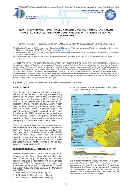
d. 0,16 to 0,48 mm/yr for the eastern (inland) part of<br />
Kyllini peninsula (125 kyrs)<br />
The most important fault zones in the study area are<br />
the Panopoulo fault zone (Panopoulo FZ), Pineios<br />
fault zone (Pineios FZ) and the strike - slip fault zone<br />
that gave rise to the Andravida earthquake (08-06-<br />
2008, ML=6,5). These major faults form several<br />
neotectonic blocks in the study area including the<br />
Gastouni graben (hangingwall of Pineios fault zone),<br />
the uplifted area of Varda (footwall of Pineios fault<br />
zone) and the Kyllini horst (Fig. 1).<br />
GEOCHRONOLOGICAL INTERPERETATION<br />
In order to determine the effect of the ongoing active<br />
tectonics on the Pineios River diversion during the<br />
late 18 th or the early 19 th century, we calculated<br />
relative uplift rates for several sites of the study area<br />
based on<br />
230 Th/ 238 U dating of corals made by<br />
Stamatopoulos et al. (1988) and dating of marine<br />
deposits in Kyllini peninsula estimated by Mariolakos<br />
et al. (1988):<br />
a. 0,39 mm/yr for Psari area (103 kyrs)<br />
b. 0,50 mm/yr for Neapoli area (118 kyrs)<br />
c. 0,67 mm/yr for Aletreika area (209 kyrs)<br />
Fig. 1: Sketch map of the contemporary Pineios river deltaic<br />
area (at the hanging wall of the Pineios fault) and the former<br />
deltaic area at the footwall of the same fault. The estimated<br />
shorelines for the Roman and Neolithic periods are shown.<br />
The archaeological sites and the sampling sites of the<br />
geochronological analysis are also noted, along with the<br />
calculated uplift rates for the last 100kyrs.<br />
42