3. - usaid
3. - usaid
3. - usaid

Create successful ePaper yourself
Turn your PDF publications into a flip-book with our unique Google optimized e-Paper software.
Complete devastation from the<br />
first explosive eruptions covered<br />
about 4.6 square miles particularly<br />
in the area between Tabacon<br />
and Pueblo Nuevo, where nothing<br />
is left but chumled up soil and<br />
ash.<br />
From July 31 to llugus t 3, only<br />
minor ash and fwnerolic activity<br />
was observed. mom August 3 to<br />
around August 10 there was considerable<br />
ash mi vapor emissions<br />
tapering off to Ikmerolic activity<br />
f'rom all three ofthe new craters<br />
formed on the west side of the<br />
mountain. Renewed explosions<br />
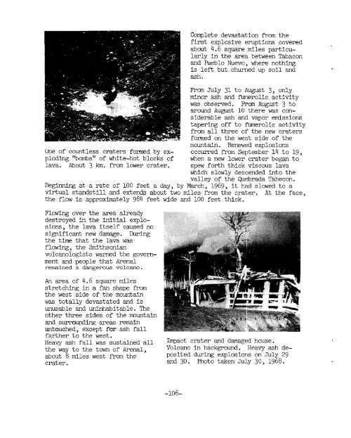
One of countless craters formed by ex- occurred from September 14 to 19,<br />
ploding "bombs" of white-hot blocks of when a new lower crater began to<br />
lava. About 3 km. f'rom lower crater. spew forth thick viscous lava<br />
which slowly descended into the<br />
valley of the Quebrada Tabecon.<br />
Beginning at a rate of 100 feet a day, by March, 1969, it had slowed to a<br />
virtual standstill and extends about two miles from the crater. At the face,<br />
the flow is approximately 984 feet wide and 100 feet thick.<br />
Flowing over the area already<br />
destroyed in the initial explosions,<br />
the lava itself caused no<br />
significant new damage. During<br />
the time that the lava was<br />
flowing, the Smithsonian<br />
volcanologists warned the govermment<br />
and people that Arenal<br />
remained a dangerous volcano.<br />
An area of 4.6 square miles<br />
stretching in a fan shape f'rom<br />
the west side of the mountain<br />
was totally devastated and is<br />
unusable and uninhabitable. The<br />
other three sides of the mountain<br />
and surrowding areas remain<br />
untouched, except for ash fall<br />
farther to the west.<br />
Heavy ash fall was sustained all %act crater and damaged house .<br />
the way to the town of Arenal, Volcano in background. Heavy ash deabout<br />
8 miles west f'rom the posited during explosiorls on July 29<br />
crater . and 30. Photo taken July 30, 1968.