3. - usaid
3. - usaid
3. - usaid

You also want an ePaper? Increase the reach of your titles
YUMPU automatically turns print PDFs into web optimized ePapers that Google loves.
U. S. Geological Survey<br />
The U. S. Geological Survey sent two geologists to make a scientific<br />
survey of the earthquake areas at the request of the Govem~nent of Iran,<br />
the U. S . Embassy, &d AID/W. John A. ~einemund, Chief, Branch of ~oreign<br />
Geology, arrived in Iran on September 8. He spent a week studying the needs<br />
for and the feasibility of a geologic study of the earthquake effects.<br />
Robert Brown followed up with a geologic study. He arrived in Iran on<br />
September 14 and remained two weeks. USGS provided AID/DRC with a copy of<br />
its Preliminary Appraisal. Expenses for MP. Reinemundls work in Iran were<br />
absorbed by the U. S. Geological Survey, while AID agreed to reimburse<br />
USGS for MP. Brown's expenses.<br />
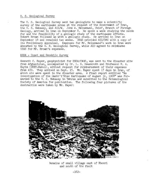
ESSA - Coast and Geodetic Survey<br />
Kenneth C. Bayer, geophysicist for ESSA/C&GS, was sent to the disaster site<br />
f'rom Afghanistan, accompanied by Dr. L. E. Heuskroth and Professor R. A.<br />
Kqim (USET-Kabul), without request for reimbursement of their expenses<br />
from AID. They arrived on Sept. 15. MP. Bayer spent 17 days in Iran, of<br />
which six were spent in the disaster area. A final report entitled "An<br />
Investigation of the Dasht i IBiaz Earthquake of ~u~ust- 31, 1968" was forwarded<br />
to the U. S. Eknbassy in Tehran and submitted to the Seismological<br />
Society of America for publication. The following four pictures of the<br />
destruction were taken by Mr. Bayer:<br />
Remains of small village east of Khezri<br />
and south of the fault