Download - GRaBS
Download - GRaBS
Download - GRaBS

Create successful ePaper yourself
Turn your PDF publications into a flip-book with our unique Google optimized e-Paper software.
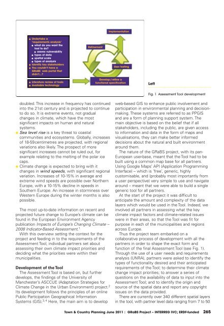
Implementation<br />
l<br />
l<br />
l<br />
Undertake a<br />
‘requirements analysis’<br />
l what do you want the<br />
tool to do?<br />
l assess vulnerability<br />
l types of data<br />
l spatial scale<br />
l types of analysis<br />
Identify key stakeholders<br />
You couldn’t have a<br />
<strong>GRaBS</strong> web portal that<br />
didn’t...?<br />
Refinement<br />
User testing<br />
l<br />
l<br />
Literature review of tools<br />
Available technology<br />
Develop/refine a<br />
functional specification<br />
Left<br />
Fig. 1 Assessment Tool development<br />
doubled. This increase in frequency has continued<br />
into the 21st century and is projected to continue<br />
to do so. It is extreme events, not gradual<br />
changes in climate, which have the most<br />
significant impacts on human and natural<br />
systems.<br />
● Sea level rise is a key threat to coastal<br />
communities and ecosystems. Globally, increases<br />
of 18-59centimetres are projected, with regional<br />
variations also likely. The prospect of more<br />
significant increases cannot be ruled out, for<br />
example relating to the melting of the polar ice<br />
caps.<br />
● Climate change is expected to bring with it<br />
changes in wind speeds, with significant regional<br />
variation. Increases of 10-15% in average and<br />
extreme wind speeds are possible over Northern<br />
Europe, with a 10-15% decline in speeds in<br />
Southern Europe. An increase in storminess over<br />
Western Europe during the winter months is also<br />
possible.<br />
The most up-to-date information on recent and<br />
projected future change to Europe’s climate can be<br />
found in the European Environment Agency<br />
publication Impacts of Europe’s Changing Climate –<br />
2008 Indicator-Based Assessment. 1<br />
With this overview setting the context for the<br />
project and feeding in to the requirements of the<br />
Assessment Tool, individual partners set about<br />
assessing their own climate impact priorities and<br />
deciding what the priorities were within their<br />
municipalities.<br />
Development of the Tool<br />
The Assessment Tool is based on, but further<br />
develops, the findings of the University of<br />
Manchester’s ASCCUE (Adaptation Strategies for<br />
Climate Change in the Urban Environment) project. 2<br />
Its development follows the principles of an online<br />
Public Participation Geographical Information<br />
Systems (GIS). 3, 4 Here, the main aim is to develop<br />
web-based GIS to enhance public involvement and<br />
participation in environmental planning and decisionmaking.<br />
These systems are referred to as PPGIS<br />
and are a form of planning support system. The<br />
main objective is based on the belief that if all<br />
stakeholders, including the public, are given access<br />
to information and data in the form of maps and<br />
visualisations, they can make better informed<br />
decisions about the natural and built environment<br />
around them.<br />
The nature of the <strong>GRaBS</strong> project, with its pan-<br />
European user-base, meant that the Tool had to be<br />
built using a common map base for all partners.<br />
Using Google Maps’ API (Application Programming<br />
Interface) – which is ‘free’, generic, highly<br />
customisable, and (probably most importantly from<br />
a user perspective) very simple to use and navigate<br />
around – meant that we were able to build a single<br />
generic tool for all partners.<br />
At the start of the project it was difficult to<br />
anticipate the amount and complexity of the data<br />
layers which would be used in the Tool. Indeed, we<br />
involved all partners in assessing what the key<br />
climate impact factors and climate-related issues<br />
were in their areas, so that the Tool was fit for<br />
purpose in each of the municipalities and regions<br />
across Europe.<br />
Thus the project team embarked on a<br />
collaborative process of development with all the<br />
partners in order to shape the exact form and<br />
function of the final Assessment Tool (see Fig. 1).<br />
Through the use of a user needs and requirements<br />
analysis (UNRA), partners were asked to identify the<br />
types of functionality desired and their anticipated<br />
requirements of the Tool; to determine their climate<br />
change impact priorities; to answer a series of<br />
questions on the availability of data to input into the<br />
Assessment Tool; and to identify the origin and<br />
source of the spatial data and report any copyright<br />
issues on the data provided.<br />
There are currently over 340 different spatial layers<br />
in the tool, with partner level data ranging from 7 to 50<br />
Town & Country Planning June 2011 : <strong>GRaBS</strong> Project – INTERREG IVC; ERDF-funded 265