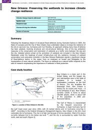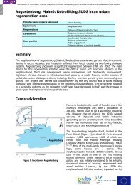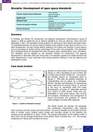
Download - GRaBS
Download - GRaBS
Download - GRaBS

You also want an ePaper? Increase the reach of your titles
YUMPU automatically turns print PDFs into web optimized ePapers that Google loves.
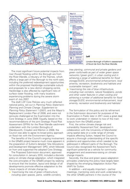
Left<br />
London Borough of Sutton’s assessment<br />
of flood risk from the River Wandle<br />
The most significant future potential impacts from<br />
river (fluvial) flooding within the Borough are from<br />
the River Wandle, a tributary of the Thames, which<br />
affects a large part of the Borough to the north east,<br />
including the preferred redevelopment opportunities<br />
within the proposed Hackbridge sustainable suburb<br />
and proposals for a new district shopping centre.<br />
Hackbridge is also affected by significant risks of<br />
surface water flooding, with many locations<br />
experiencing problems during the severe storm<br />
event of July 2007.<br />
The draft LDF Core Policies very much reflected<br />
national policy, set out in Planning Policy Statement:<br />
Planning and Climate Change. Supplement to<br />
Planning Policy Statement 1 (2007), and the Mayor’s<br />
Replacement London Plan of 2008, and were not<br />
seriously challenged at the Examination into the<br />
Core Strategy in June 2009. Equally, based on the<br />
recommendations of the joint Strategic Flood Risk<br />
Assessment (SFRA) for the River Wandle catchment<br />
undertaken with the London Boroughs of<br />
Wandsworth, Croydon and Merton in 2008, the<br />
Council was able to agree its broad policy approach<br />
on flood risk with the Environment Agency.<br />
The benefits of the Council’s ongoing involvement<br />
in the <strong>GRaBS</strong> project became much more apparent in<br />
the preparation of Sutton’s detailed ‘Site Allocations<br />
and Development Management’ DPD, which followed<br />
on from and supported the adopted Core Strategy.<br />
The Proposed Submission document, approved<br />
for consultation in January 2010, included a discrete<br />
policy on climate change adaptation, which integrated<br />
the core principles of the <strong>GRaBS</strong> project by seeking<br />
to ensure that the location, layout and design of all<br />
developments promote effective adaptation to the<br />
future impacts of climate change by:<br />
● ‘maximising the role of green infrastructure,<br />
including open spaces, parks, wildlife corridors,<br />
tree planting, communal and private gardens and<br />
green roofs/walls as part of wider green space<br />
networks (‘green grid’), in urban cooling and in<br />
achieving a range of additional benefits for flood<br />
storage/SUDS, environmental enhancement, local<br />
amenity, recreation, biodiversity and habitats and<br />
sustainable transport’; and<br />
● ‘maximising the role of blue infrastructure,<br />
including river corridors, natural floodplains, ponds<br />
and other water features in urban cooling and<br />
achieving a number of additional benefits for flood<br />
storage/SUDS, environmental enhancement, local<br />
amenity, recreation and biodiversity and habitats’.<br />
The formulation of this policy and its refinement<br />
in the Submission document for purposes of the<br />
Examination in Public later in 2011 owes a great deal<br />
to work undertaken in relation to two of the main<br />
outputs from the <strong>GRaBS</strong> project.<br />
First, the online climate change risk and<br />
vulnerability ‘Assessment Tool’, developed in<br />
collaboration with the University of Manchester<br />
using spatial data on a wide range of climate<br />
impacts affecting Sutton, helped the Council to<br />
acquire a thorough understanding of the specific<br />
problems and opportunities which needed to be<br />
addressed in different parts of the Borough. The<br />
Council also recognised the Assessment Tool’s<br />
significant potential as a vehicle for community<br />
engagement and awareness-raising on climate<br />
change impacts.<br />
Secondly, the blue and green space adaptation<br />
principles underlying this policy have largely been<br />
shaped by the emerging Adaptation Action Plan<br />
(AAP) for Sutton.<br />
In addition – and equally important – partner<br />
meetings, mentoring visits and work undertaken by<br />
the other <strong>GRaBS</strong> partners in the course of the<br />
Town & Country Planning June 2011 : <strong>GRaBS</strong> Project – INTERREG IVC; ERDF-funded 283