Applying OLAP Pre-Aggregation Techniques to ... - Jacobs University
Applying OLAP Pre-Aggregation Techniques to ... - Jacobs University
Applying OLAP Pre-Aggregation Techniques to ... - Jacobs University

Create successful ePaper yourself
Turn your PDF publications into a flip-book with our unique Google optimized e-Paper software.
20 2. Background and Related Work<br />
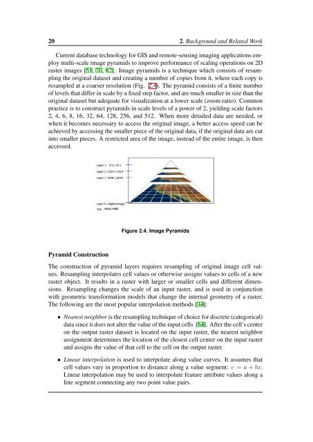
Current database technology for GIS and remote-sensing imaging applications employ<br />
multi-scale image pyramids <strong>to</strong> improve performance of scaling operations on 2D<br />
raster images [51, 70, 82]. Image pyramids is a technique which consists of resampling<br />
the original dataset and creating a number of copies from it, where each copy is<br />
resampled at a coarser resolution (Fig. 2.4). The pyramid consists of a finite number<br />
of levels that differ in scale by a fixed step fac<strong>to</strong>r, and are much smaller in size than the<br />
original dataset but adequate for visualization at a lower scale (zoom ratio). Common<br />
practice is <strong>to</strong> construct pyramids in scale levels of a power of 2, yielding scale fac<strong>to</strong>rs<br />
2, 4, 6, 8, 16, 32, 64, 128, 256, and 512. When more detailed data are needed, or<br />
when it becomes necessary <strong>to</strong> access the original image, a better access speed can be<br />
achieved by accessing the smaller piece of the original data, if the original data are cut<br />
in<strong>to</strong> smaller pieces. A restricted area of the image, instead of the entire image, is then<br />
accessed.<br />
Figure 2.4. Image Pyramids<br />
Pyramid Construction<br />
The construction of pyramid layers requires resampling of original image cell values.<br />
Resampling interpolates cell values or otherwise assigns values <strong>to</strong> cells of a new<br />
raster object. It results in a raster with larger or smaller cells and different dimensions.<br />
Resampling changes the scale of an input raster, and is used in conjunction<br />
with geometric transformation models that change the internal geometry of a raster.<br />
The following are the most popular interpolation methods [34]:<br />
• Nearest neighbor is the resampling technique of choice for discrete (categorical)<br />
data since it does not alter the value of the input cells [64]. After the cell’s center<br />
on the output raster dataset is located on the input raster, the nearest neighbor<br />
assignment determines the location of the closest cell center on the input raster<br />
and assigns the value of that cell <strong>to</strong> the cell on the output raster.<br />
• Linear interpolation is used <strong>to</strong> interpolate along value curves. It assumes that<br />
cell values vary in proportion <strong>to</strong> distance along a value segment: v = a + bx.<br />
Linear interpolation may be used <strong>to</strong> interpolate feature attribute values along a<br />
line segment connecting any two point value pairs.