Applying OLAP Pre-Aggregation Techniques to ... - Jacobs University
Applying OLAP Pre-Aggregation Techniques to ... - Jacobs University
Applying OLAP Pre-Aggregation Techniques to ... - Jacobs University

You also want an ePaper? Increase the reach of your titles
YUMPU automatically turns print PDFs into web optimized ePapers that Google loves.
5.5 Experimental Results 85<br />
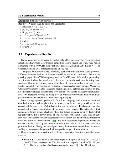
Algorithm 4 REWRITEOPERATION<br />
Require: A query q, and a set of pre-aggregates P<br />
1: initialize S = {} , p id = 0<br />
2: p id = fullMatch(q, P )<br />
3: if (p id == 0) then<br />
4: S = partialMatch(q, P )<br />
5: p id = closestScaleV ec<strong>to</strong>r(q, S)<br />
6: end if<br />
7: q ′ = rewriteQuery(q, p id )<br />
8: return q ′<br />
5.5 Experimental Results<br />
Experiments were conducted <strong>to</strong> evaluate the effectiveness of the pre-aggregation<br />
selection and rewriting algorithms in supporting scaling operations. They were run on<br />
a machine with a 3.00 GHz Intel Pentium 4 processor, running SuSe Linux 9.1. The<br />
workstation had a <strong>to</strong>tal physical memory of 512 MB.<br />
The query workload consisted of scaling operations with different scaling vec<strong>to</strong>rs.<br />
Different data distributions of the query workload were also considered. Despite the<br />
growing popularity of Web mapping services for GIS raster information processing,<br />
very few studies have been undertaken that report on user behaviors while using those<br />
services. One of the primary reasons for lack of research in this area may be the<br />
limited availability of the datasets outside of specialized research groups. Moreover,<br />
while query patterns related <strong>to</strong> scaling operations on 2D datasets are difficult <strong>to</strong> find,<br />
no empirical workload distributions were found for datasets of higher dimensionalities.<br />
We therefore resorted <strong>to</strong> using a set of artificial distributions that cover many<br />
practical situations in GIS and remote-sensing imaging.<br />
Most pre-aggregation algorithms in <strong>OLAP</strong> and image pyramids assume a uniform<br />
distribution of the values given for the scale vec<strong>to</strong>r in the query workload, so we<br />
considered the same type of distribution for our experiments. Furthermore, we also<br />
considered a Poisson distribution of the scale vec<strong>to</strong>r values. The rationale is that<br />
such a distribution covers situations where the dataset is scaled down by fac<strong>to</strong>rs that<br />
typically fall within a narrow range of scale vec<strong>to</strong>rs. For example, very large objects<br />
may need <strong>to</strong> be scaled down by large scale vec<strong>to</strong>rs so they can be efficiently transferred<br />
back and forth via Web services [77]. We also considered applications where the<br />
dataset is scaled down by the same scale vec<strong>to</strong>r, we refer <strong>to</strong> such access patter as a<br />
peak distribution. Finally, we investigated a step distribution that satisfies cases where<br />
scaling operations can be grouped within specific ranges of scale vec<strong>to</strong>rs.<br />
Our experiments were performed on datasets generated from three real-life rasterobjects:<br />
• Dataset R1. Consists of a 2D raster object with spatial domain [0 : 15359, 0 :<br />
10239]. The dataset contains 600 tiles, each with a spatial domain of [0 : 512, 0 :<br />
512]. The <strong>to</strong>tal number of cells composing the raster object is 157 millions.