ecological characterization atlas of coastal alabama - Data Center
ecological characterization atlas of coastal alabama - Data Center
ecological characterization atlas of coastal alabama - Data Center
Create successful ePaper yourself
Turn your PDF publications into a flip-book with our unique Google optimized e-Paper software.
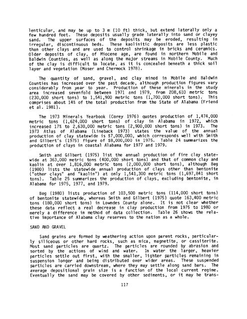
lenticular, and may be up to 3 m (10 ft) thick, but extend laterally only a<br />
few hundred feet . These deposits usually grade laterally into sand or clayey<br />
sand . The upper surfaces <strong>of</strong> the deposits may be eroded, resulting in<br />
irregular, discontinuous beds . These kaolinitic deposits are less plastic<br />
than other clays and are used too control shrinkage in bricks and ceramics .<br />
Older deposits <strong>of</strong> clay, <strong>of</strong> Miocene age, are found in northern Mobile and<br />
Baldwin Counties, as well as along the major streams in Mobile County . Much<br />
<strong>of</strong> the cl ay i s di ffi c ul t to l ocate , as i t i s conceal ed beneath a thi c k soi l<br />
layer and vegetation (Moser and Chermock 1978) .<br />
The quantity <strong>of</strong> sand, gravel, and clay mined in Mobile and Baldwin<br />
Counties has increased over the past decade, although production figures vary<br />
considerably from year to year . Production <strong>of</strong> these minerals in the study<br />
area increased sevenfold between 1971 and 1979, from 208,610 metric tons<br />
(230,000 short tons) to 1,541,900 metric tons (1,700,000 short tons) . This<br />
comprises about 14% <strong>of</strong> the total production from the State <strong>of</strong> Alabama (Friend<br />
et al . 1981) .<br />
The 1973 Minerals Yearbook (Corey 1976) quotes production <strong>of</strong> 1,474,000<br />
metric tons (1,624,000 short tons) <strong>of</strong> clay in Alabama in 1972, which<br />
increased 17% to 2,630,000 metric tons (2,900,000 short tons) in 1973 . The<br />
1973 Atlas <strong>of</strong> Alabama (Lineback 1973) states the value <strong>of</strong> the annual<br />
production <strong>of</strong> clay statewide is $7,000,000, which corresponds well with Smith<br />
and Gilbert's (1975) figure <strong>of</strong> $8,000,000 in 1975 . Table 24 summarizes the<br />
production <strong>of</strong> clays in <strong>coastal</strong> Alabama for 1977 and 1979 .<br />
Smith and Gilbert (1975) list the annual production <strong>of</strong> fire clay statewide<br />
at 363,000 metric tons (400,000 short tons) and that <strong>of</strong> common clay and<br />
kaolin at over 1,816,000 metric tons (2,000,000 short tons), although Beg<br />
(1980) lists the statewide annual production <strong>of</strong> clays other than bentonite<br />
("other clays" and "kaolin") at only 1,541,300 metric tons (1,697,841 short<br />
tons) . Table 25 summarizes the production <strong>of</strong> clays, excl uding bentonite, in<br />
Alabama for 1975, 1977, and 1979 .<br />
Beg (1980) lists production <strong>of</strong> 103,500 metric tons (114,000 short tons)<br />
<strong>of</strong> bentonite statewide, whereas Smith and Gilbert (1975) quote 163,400 metric<br />
tons (180,000 short tons) in Lowndes County alone . It is not clear whether<br />
these data reflect a real decrease in clay production from 1975 to 1980 or<br />
merely a difference in method <strong>of</strong> data collection . Table 26 shows the relative<br />
im portance <strong>of</strong> Alabama clay reserves to the nation as a whole .<br />
SAND AND GRAVEL<br />
Sand grains are formed by weathering action upon parent rocks, partic ularly<br />
siliceous or other hard rocks, such as mica, magnetite, or cassiterite .<br />
Most sand particles are quartz . The particles are rounded by abrasion and<br />
sorted by the actions <strong>of</strong> wind and water . In water the larger, heavier<br />
particles settle out first, with the smaller, lighter particles remaining in<br />
suspension longer and being distributed over wider areas . These suspended<br />
particles are carried downstream, where they may settle along sand bars . The<br />
average depositional grain size is a function <strong>of</strong> the local current regime .<br />
Eventually the sand may be covered by other sediments, or it may be trans-<br />
117


