- Page 1 and 2:
FWS/OBS-82/46 August 1984 MMS 84-00
- Page 3 and 4:
Library of Congress Card No . 85-60
- Page 5 and 6:
SUMMARY The southwest Alabama coast
- Page 7 and 8:
CONTENTS PREFACE . . . . . . . . .
- Page 9 and 10:
Page CL IMATOLOGY AND HYDROLOGY . .
- Page 11 and 12:
Number Page 14 Frequency of destruc
- Page 13 and 14:
Number Page 13 Charter boats and he
- Page 15 and 16:
Number Pa e 49 Summary of geologic
- Page 17 and 18:
Mobile Area Chamber of Commerce Mob
- Page 19 and 20:
water . Plants and animals not phys
- Page 21 and 22:
and white ibis (Eudocimus aTbus) .
- Page 23 and 24:
Grant's Island (Biloxi quadrangle)
- Page 25 and 26:
Table 2 . Average annual waterfowl
- Page 27 and 28:
(widgeongrass) is the dominant seag
- Page 29 and 30:
(Benson 1982) . Brown and white shr
- Page 31 and 32:
Table 4 . Commercial landings of se
- Page 33 and 34:
Table 5 . Estimated recreational ca
- Page 35 and 36:
offshore waters from December throu
- Page 37 and 38:
Unless otherwise specified, the fol
- Page 39 and 40:
Table 7 . Recommended State of Alab
- Page 41 and 42:
Table 7 . (concluded) Recommended s
- Page 43 and 44:
(Mount 1975 ) . Thi s speci es i s
- Page 45 and 46:
REFERENCES Wetland Habitats Cowardi
- Page 47 and 48:
Stout, J . P ., and M . J . Lelong
- Page 49 and 50:
Guest, W . C ., and G . Gunter . 19
- Page 51 and 52:
SOURCES OF MAPPED INFORMATION Wetla
- Page 53 and 54:
In April and June 1978 the Gulf of
- Page 55 and 56:
distribution of the species are dis
- Page 57 and 58:
landed, the value of the seafood la
- Page 59 and 60:
Service publication Alabama Coastal
- Page 61 and 62:
year, over 2 million individual bir
- Page 63 and 64:
The Styx, Blackwater, and Perdido R
- Page 65 and 66:
It was estimated ( Table 9) that 2
- Page 67 and 68:
Table 10 . Average daily two-way tr
- Page 69 and 70:
while the majority in Mobile County
- Page 71 and 72:
mouth of Mobile Bay has tremendous
- Page 73 and 74:
SOLID WASTE LANDFILLS AND ONSHORE D
- Page 75 and 76:
Table 15 . Areas of Alabama estuari
- Page 77 and 78:
Cavellero House (1) 7 North Jackson
- Page 79 and 80:
Horst House ("Moongate") (1) 186 ;
- Page 81 and 82:
Spring Hill College Quadrangle (1)
- Page 83 and 84:
periods . Hallmarks of the Woodland
- Page 85 and 86:
Table 16 . Maintained navigable cha
- Page 87 and 88:
Mobil Oil discovered gas in a deep
- Page 89 and 90:
National Natural Landmarks Boschung
- Page 91 and 92:
May, E . B . 1976 . Holocene sedime
- Page 93 and 94:
U .S . Army Corps of Engineers . 19
- Page 95 and 96:
Intensively Used Recreation Beaches
- Page 97 and 98:
Man-Made Land Baxter J ., 15 Decemb
- Page 99 and 100:
SOILS AND LANDFORMS INTRODUCTION Th
- Page 101 and 102:
oad flood plains of the Mobile/Alab
- Page 103 and 104:
At elevations of about 30 m (100 ft
- Page 105 and 106:
The Troup-Benndale-Smithton soil as
- Page 107 and 108:
Table 19 . Potential uses and limit
- Page 109 and 110:
Somewhat the same situation exists
- Page 111 and 112:
due to limitations of Landsat cover
- Page 113 and 114:
decrease in sediment being transpor
- Page 115 and 116:
Changes in Perdido Pass are among t
- Page 117 and 118:
60 m (100 to 200 ft), and some of t
- Page 119 and 120:
REFERENCES Alabama Coastal Area Boa
- Page 121 and 122:
SOURCES OF MAPPED INFORMATION Soil
- Page 123 and 124:
Active Dunes Alabama Coastal Area B
- Page 125 and 126:
: EXPLANATION ERATHEM SYSTEM SERIES
- Page 127 and 128:
carbon component of the production
- Page 129 and 130:
Table 20 . Oil facilities in coasta
- Page 131 and 132:
Oil and gas production statistics f
- Page 133 and 134:
CLAY Clay is a ubiquitous mineral r
- Page 135 and 136:
Table 24 . Production (net tons) of
- Page 137 and 138:
Table 27 . Geologic strata containi
- Page 139 and 140: excavation (Smith and Gilbert 1975)
- Page 141 and 142: REFERENCES OIL AND GAS Alabama Coas
- Page 143 and 144: SAND AND GRAVEL Alabama Coastal Are
- Page 145 and 146: SOURCES OF MAPPED INFORMATION OIL A
- Page 147 and 148: CLIMATOLOGY AND HYDROLOGY INTRODUCT
- Page 149 and 150: Table 32 . Rainfall in coastal Alab
- Page 151 and 152: systems to extend into the gulf are
- Page 153 and 154: These storms have the potential to
- Page 155 and 156: average forward speed of hurricanes
- Page 157 and 158: Table 35 . Hurricane surges in Alab
- Page 159 and 160: occurs when water rises above the w
- Page 161 and 162: Table 37 . Monthly mean discharges
- Page 163 and 164: Alabama River C L u z O W L 0 u ~ Z
- Page 165 and 166: Table 41 . Chemical analyses of wat
- Page 167 and 168: ~ 0 umber (quad) tation name ate of
- Page 169 and 170: Table 42 . (concluded) isso ve su s
- Page 171 and 172: ~ -------- 00 ~ ~r I ~ . i I I ~ I
- Page 173 and 174: Table 43 . Existing municipal sewag
- Page 175 and 176: Regional Plan- Table 45 . Water qua
- Page 177 and 178: Table 46 . Average and maximum-mini
- Page 179 and 180: Table 46 . (concluded) -~Tater temp
- Page 181 and 182: Table 47 . Water-quality trends in
- Page 183 and 184: discharge from metropolitan Mobile
- Page 185 and 186: Table 49 . Summary of geologic unit
- Page 187 and 188: affected by the surface environment
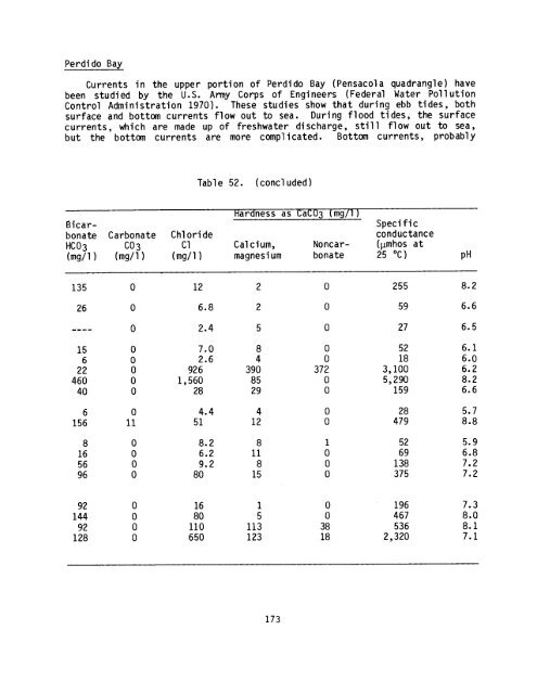
- Page 189: Longshore currents in the Gulf of M
- Page 193 and 194: AI ARAMA ` FI (lRIf1A Figure 19 . E
- Page 195 and 196: ~ ~ l ~ l i L j + l j* l + j* ~ + j
- Page 197 and 198: REFERENCES CLIMATOLOGY AND HYDROLOG
- Page 199 and 200: Brady, D . W . 1979 . Water resourc
- Page 201 and 202: Schroeder, W . W . 1976 . Physical
- Page 203 and 204: This 25-page document gives detaile
- Page 205 and 206: Information on the location, thickn
- Page 207: H TtiF I :r ~ . ~ .~ U _ . DEPARTME


