

ecological characterization atlas of coastal alabama - Data Center
ecological characterization atlas of coastal alabama - Data Center
ecological characterization atlas of coastal alabama - Data Center

Create successful ePaper yourself
Turn your PDF publications into a flip-book with our unique Google optimized e-Paper software.
Maintenance dredging <strong>of</strong> the Mobile Ship Channel (Mobile and Biloxi quadrangles)<br />
between 1968 and 1973 produced 11,469,000 m3 net (15,000,000 yds3<br />
net) <strong>of</strong> spoil (Alabama Coastal Area Board 1979) . The average annual net<br />
volumes <strong>of</strong> dredged maintenance material produced from the Mobile Harbor<br />
system between 1967 and 1975 are shown in Table 17 .<br />
Almost all <strong>of</strong> this dredged material is dumped in disposal areas<br />
designated by the U .S . Army Corps <strong>of</strong> Engineers approximately 548 m (600 yd)<br />
on either side <strong>of</strong> most <strong>of</strong> the channels in the area . Onshore dredge spoil<br />
disposal areas include sites at Theodore (Mobile quadrangle), Bayou La Batre<br />
(Biloxi quadrangle), and Blakely Island (Mobile quadrangle) . On Blakely<br />
Island, the U .S . Army Corps <strong>of</strong> Engineers covers mineral residue ponds with<br />
dredge spoil, which provides both needed area for spoil disposal and covering<br />
for potentially harmful chemical waste (J . Baxter, U .S . Army Corps <strong>of</strong><br />
Engineers, Mobile, 15 December 1982 ; pers . comm .) .<br />
OFFSHORE OBSTRUCTIONS AND STRUCTURES<br />
The onl y maj or <strong>of</strong>fshore structures i n Mobi 1 e and Bal dwi n Counti es are the<br />
Mobile Bay Light, the Sand Island Light and three petroleum platforms<br />
associated with the Lower Mobile Bay Field (Biloxi quadrangle) . The Middle<br />
Bay Light was constructed in 1884 and is 'located, as the name implies, in the<br />
middle <strong>of</strong> Mobile Bay on the navigation channel . This structure is discussed<br />
further in the <strong>atlas</strong> section dealing with the National Register <strong>of</strong> Historic<br />
Places .<br />
The Sand Island Lighthouse is located near Sand Island about 5 km (3 mi)<br />
south <strong>of</strong> the mouth <strong>of</strong> Mobile Bay . It dates to 1873 and was abandoned in<br />
1971 . Like the Middle Bay Light, it is on the National Register <strong>of</strong> Historic<br />
Places and is discussed further in that section .<br />
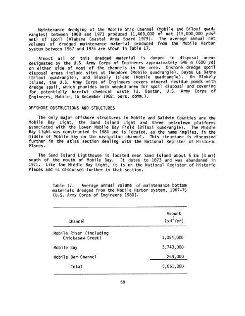
Table 17 . Average annual volume <strong>of</strong> maintenance bottom<br />
materials dredged from the Mobile Harbor system, 1967-75<br />
(U .S . Army Corps <strong>of</strong> Engineers 1980) .<br />
Amount<br />
Channel<br />
(yd3/yr)<br />
Mobile River ( including<br />
Chickasaw Creek) 1,054,000<br />
Mobile Bay 3,743,000<br />
Mobile Bar Channel 264,000<br />
Total 5,061,000<br />
69


