

ecological characterization atlas of coastal alabama - Data Center
ecological characterization atlas of coastal alabama - Data Center
ecological characterization atlas of coastal alabama - Data Center

You also want an ePaper? Increase the reach of your titles
YUMPU automatically turns print PDFs into web optimized ePapers that Google loves.
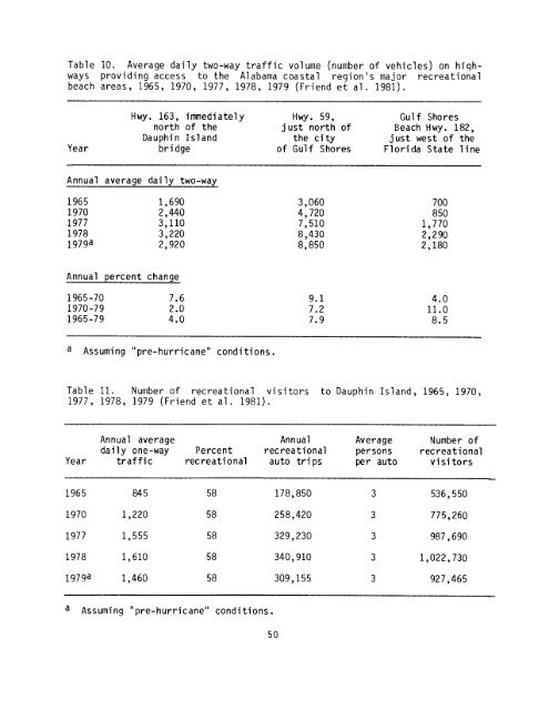
Table 10 . Average daily two-way traffic volume (number <strong>of</strong> vehicles) on highways<br />
providing access to the Alabama <strong>coastal</strong> region's major recreational<br />
beach areas, 1965, 1970, 1977, 1978, 1979 (Friend et al . 1981) .<br />
H wy . 163, immediately Hwy . 59, Gulf Shores<br />
north <strong>of</strong> the just north <strong>of</strong> Beach H wy . 182,<br />
Dauphin Island the city just west <strong>of</strong> the<br />
Year bridge <strong>of</strong> Gulf Shores Florida State line<br />
Annual average<br />
daily two-way<br />
1965 1,690 3,060 700<br />
1970 2,440 4,720 850<br />
1977 3,110 7,510 1,770<br />
1978 3,220 8,430 2,290<br />
1979a 2,920 8,850 2,180<br />
Annual percent<br />
change<br />
1965-70 7 .6 9 .1 4 .0<br />
1970-79 2 .0 7 .2 11 .0<br />
1965-79 4 .0 7 .9 8 .5<br />
a Assuming "pre-hurricane" conditions .<br />
Table 11 . Number <strong>of</strong> recreational visitors to Dauphin Island, 1965, 1970,<br />
1977, 1978, 1979 (Friend et al . 1981) .<br />
Annual average Annual Average Number <strong>of</strong><br />
daily one-way Percent recreational persons recreational<br />
Year traffic recreational auto trips per auto visitors<br />
1965 845 58 178,850 3 536,550<br />
1970 1,220 58 258,420 3 775,260<br />
1977 1,555 58 329,230 3 987,690<br />
1978 1,610 58 340,910 3 1,022,730<br />
1979a 1,460 58 309,155 3 927,465<br />
a Assuming "pre-hurricane" conditions .<br />
50


