Annual Report 2006 (main body) - RTA - NSW Government
Annual Report 2006 (main body) - RTA - NSW Government
Annual Report 2006 (main body) - RTA - NSW Government

Create successful ePaper yourself
Turn your PDF publications into a flip-book with our unique Google optimized e-Paper software.
of the need to stabilise the embankments on<br />
the soft soil section of Richmond River<br />
floodplain.This project is jointly funded by the<br />
<strong>NSW</strong> and Australian <strong>Government</strong>s.<br />
Brunswick Heads to Yelgun<br />
Construction began in July 2005 on this<br />
$256 million, 8.6 kilometre project. It<br />
involves construction of a new dual<br />
carriageway generally adjacent to the<br />
current highway north of Brunswick<br />
Heads and a second carriageway on the<br />
Brunswick Heads Bypass. The project is<br />
jointly funded by the <strong>NSW</strong> and Australian<br />
<strong>Government</strong>s.<br />
Tugun Bypass<br />
Construction has commenced on the Tugun<br />
Bypass. Early essential construction works<br />
began in April <strong>2006</strong>.The bypass will connect<br />
the Pacific Motorway between Stewart Road<br />
interchange at Currumbin and the Tweed<br />
Heads Bypass north of Kennedy Drive. The<br />
project is being funded by the Australian and<br />
Queensland <strong>Government</strong>s with technical<br />
assistance provided by the <strong>RTA</strong> to facilitate<br />
construction of the project. Planning approval<br />
has been received for the seven kilometre<br />
<strong>NSW</strong> section of the Tugun Bypass.<br />
Other highlights<br />
Preferred routes have been selected for the<br />
following projects and planning continues.<br />
Macksville to Urunga (40 km,<br />
including the Warrell Creek project).<br />
Woodburn to Ballina (32 km).<br />
Iluka Road to Woodburn (35 km,<br />
concept design along existing alignment).<br />
Failford Road to Tritton Road<br />
(3.3 km, concept design along<br />
existing alignment).<br />
Herons Creek to Stills Road (3.3 km,<br />
concept design along existing alignment).<br />
Route options displays have been released<br />
for:<br />
F3 to Raymond Terrace (12.2 km).<br />
Oxley Highway to Kempsey (38.8 km).<br />
Woolgoolga to Wells Crossing (27.8 km).<br />
Wells Crossing to Iluka Road (78 km).<br />
Tintenbar to Ewingsdale (17 km).<br />
Planning is also continuing for:<br />
Bulahdelah Upgrade (9 km).<br />
Karuah to Bulahdelah Sections 2<br />
and 3 (23 km).<br />
Coopernook to Moorland (10 km).<br />
Moorland to Herons Creek (22 km).<br />
Kempsey to Eungai (39 km).<br />
Coffs Harbour Highway Planning<br />
Strategy (12 km).<br />
Sapphire to Woolgoolga (24 km).<br />
Ballina Bypass (Main contract – 12.4 km).<br />
Banora Point (2.5 km).<br />
SYDNEY PROJECTS<br />
Windsor Road upgrade<br />
The program to upgrade Windsor Road<br />
and Old Windsor Road to a minimum of<br />
four lanes is progressing with substantial<br />
construction on:<br />
Roxborough Park Road to Norwest<br />
Boulevarde, Baulkham Hills.<br />
Acres Road to Old Windsor Road,<br />
Kellyville.<br />
Mile End Road, Rouse Hill<br />
to Boundary Road, Box Hill.<br />
Boundary Road, Box Hill to<br />
Level Crossing Road,Vineyard.<br />
These sections are due to open to traffic<br />
progressively from July <strong>2006</strong>, at which time<br />
Windsor and Old Windsor roads will have<br />
been upgraded to four lanes between<br />
Parramatta and McGraths Hill.<br />
The contract for construction of the final<br />
project in the program, the $120 million<br />
Windsor flood evacuation route across<br />
South Creek, was awarded in September<br />
2005 and work is in progress on the major<br />
bridge and approaches.<br />
The Windsor Road upgrade is improving<br />
the accessibility, safety and reliability of travel<br />
in the north-west sector of Sydney. The<br />
upgrade will significantly contribute to<br />
economic development in Western Sydney,<br />
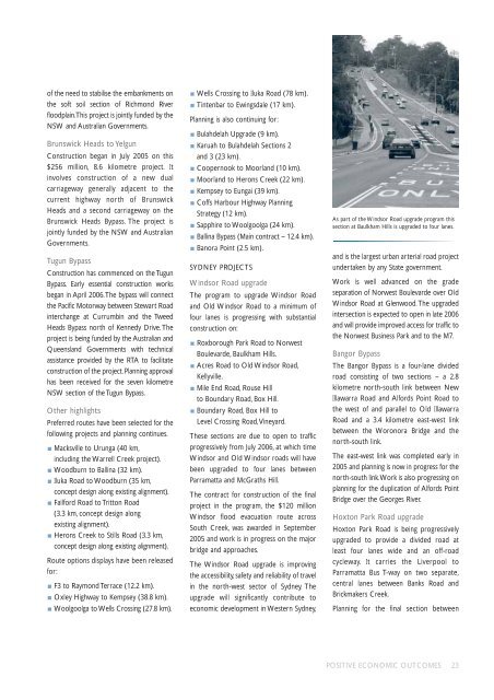
As part of the Windsor Road upgrade program this<br />
section at Baulkham Hills is upgraded to four lanes.<br />
and is the largest urban arterial road project<br />
undertaken by any State government.<br />
Work is well advanced on the grade<br />
separation of Norwest Boulevarde over Old<br />
Windsor Road at Glenwood. The upgraded<br />
intersection is expected to open in late <strong>2006</strong><br />
and will provide improved access for traffic to<br />
the Norwest Business Park and to the M7.<br />
Bangor Bypass<br />
The Bangor Bypass is a four-lane divided<br />
road consisting of two sections – a 2.8<br />
kilometre north-south link between New<br />
Illawarra Road and Alfords Point Road to<br />
the west of and parallel to Old Illawarra<br />
Road and a 3.4 kilometre east-west link<br />
between the Woronora Bridge and the<br />
north-south link.<br />
The east-west link was completed early in<br />
2005 and planning is now in progress for the<br />
north-south link.Work is also progressing on<br />
planning for the duplication of Alfords Point<br />
Bridge over the Georges River.<br />
Hoxton Park Road upgrade<br />
Hoxton Park Road is being progressively<br />
upgraded to provide a divided road at<br />
least four lanes wide and an off-road<br />
cycleway. It carries the Liverpool to<br />
Parramatta Bus T-way on two separate,<br />
central lanes between Banks Road and<br />
Brickmakers Creek.<br />
Planning for the final section between<br />
POSITIVE ECONOMIC OUTCOMES 23