March 2004 - Society for California Archaeology
March 2004 - Society for California Archaeology
March 2004 - Society for California Archaeology

You also want an ePaper? Increase the reach of your titles
YUMPU automatically turns print PDFs into web optimized ePapers that Google loves.
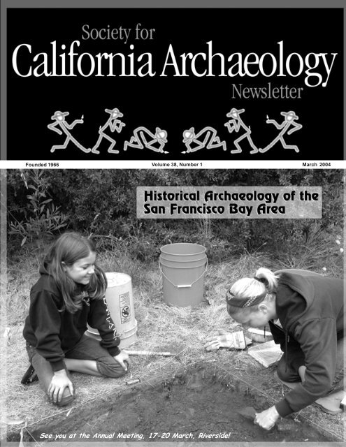
Founded 1966 Volume 38, Number 1<br />
<strong>March</strong> <strong>2004</strong><br />
See you at the Annual Meeting, 17-20 <strong>March</strong>, Riverside!
○ ○ ○ ○ ○ ○ ○ ○ ○ ○ ○ ○ ○ ○ ○ ○ ○ ○ ○ ○ ○ ○ ○ ○ ○ ○ ○ ○ ○ ○ ○ ○ ○ ○ ○ ○ ○ ○ ○ ○ ○ ○ ○ ○ ○ ○ ○ ○ ○ ○ ○ ○ ○ ○ ○ ○ ○ ○ ○ ○ ○ ○ ○ ○ ○ ○ ○ ○ ○ ○ ○ ○ ○ ○ ○ ○ ○ ○ ○ ○ ○ ○ ○ ○ ○ ○ ○ ○<br />
2<br />
<strong>Society</strong> <strong>for</strong> Cali<strong>for</strong>nia <strong>Archaeology</strong> Newsletter<br />
Volume 38, Number 1, <strong>March</strong> <strong>2004</strong><br />
A quarterly newsletter of articles and in<strong>for</strong>mation essential<br />
to Cali<strong>for</strong>nia archaeology. Contributions are welcome.<br />
Lead articles should be 1,500-2,000 words. Longer articles<br />
may appear in installments. Send submissions as hard<br />
copy or on diskette to: SCA Newsletter, Department of<br />
Anthropology, CSU Chico, Chico CA 95929-0400 or as<br />
email or attachments to:<br />
<br />
The SCA Executive Board encourages publication of a<br />
wide range of opinions on issues pertinent to Cali<strong>for</strong>nia<br />
archaeology. Opinions, commentary, and editorials<br />
appearing in the Newslette represent the views of the<br />
authors, and not necessarily those of the Board or Editor.<br />
Lead article authors should be aware that their articles<br />
may appear on the SCA web site, unless they request<br />
otherwise.<br />
Editorial Staff<br />
Managing Editor . . . . . . . Greg White (530) 898-4360<br />
Editorial Assistance . Melinda Pacheco (530) 898-5733<br />
Contributing Editors<br />
Avocational News . . . . . Jerry Dudley/Myra Herrmann<br />
Curation . . . . . . . . . . . . . . . . . . . . . . Cindy Stankowski<br />
Education . . . . . . . . . . . . . . . . . . . . . . . . . Mary Gorden<br />
Federal Agency News . . . . . . . . . . . . . Russ Kaldenberg<br />
Historical <strong>Archaeology</strong> . . . . . . . . . . . . . . . . . . . . . . open<br />
In<strong>for</strong>mation Centers . . . . . . . . . . . . . . . . Lynn Compas<br />
Membership . . . . . . . . . . . . . . . . Stacy Schneyder Case<br />
New Publications . . . . . . . . . . . . . . . . . Denise Thomas<br />
OHP . . . . . . . . . . . . . . . . . . . . . . . . . . Michael McGuirt<br />
Legislation . . . . . . . . . . . . . . . . . . . . . . . Stephen Bryne<br />
CASSP . . . . . . . . . . . . . . . . . . . . . Chris and Beth Padon<br />
State Agency News . . . . . . . . . . . . . . . . . . . . . . . . . open<br />
Newsletter Deadlines<br />
For Issue . . . . . . . . . . . . . . . . . . . . . . . . . . . . . Deadline<br />
<strong>March</strong> . . . . . . . . . . . . . . . . . . . . . . . . . . . . . February 20<br />
June . . . . . . . . . . . . . . . . . . . . . . . . . . . . . . . . . . May 20<br />
September . . . . . . . . . . . . . . . . . . . . . . . . . . . August 20<br />
December . . . . . . . . . . . . . . . . . . . . . . . . November 20<br />
Calendar Submissions<br />
position open: . . . . . . . . . . . temporarily send submissions<br />
to gwhite@csuchico.edu<br />
Advertising Rates<br />
1/4 page . . . . . . . . . . . . . . . . . . . . . . . . . . . . . . . . . . $70<br />
1/2 page . . . . . . . . . . . . . . . . . . . . . . . . . . . . . . . . . $100<br />
Full page . . . . . . . . . . . . . . . . . . . . . . . . . . . . . . . . . $175<br />
Ads that run three or more consecutive issues receive a<br />
15% discount.<br />
Regular Features<br />
From the President<br />
Elena Nilsson . . . . . . . . . . . . . . . . . . . . . . . . . . . . . . . . . . . . . . . . . . . . . . . . . . . . . . . . . . . . . . . . 3<br />
SCA Business and Activities<br />
Native American Programs . . . . . . . . . . . . . . . . . . . . . . . . . . . . . . . . . . . . . . . . . . . . . . . . . . . . . 4<br />
Legislative Liaison Report . . . . . . . . . . . . . . . . . . . . . . . . . . . . . . . . . . . . . . . . . . . . . . . . . . . . . . 4<br />
Site Stewardship . . . . . . . . . . . . . . . . . . . . . . . . . . . . . . . . . . . . . . . . . . . . . . . . . . . . . . . . . . . . . 7<br />
News and Announcements<br />
Table Bluff Rancheria THPO . . . . . . . . . . . . . . . . . . . . . . . . . . . . . . . . . . . . . . . . . . . . . . . . . . 8<br />
New ACHP Web Page . . . . . . . . . . . . . . . . . . . . . . . . . . . . . . . . . . . . . . . . . . . . . . . . . . . . . . . 10<br />
11 th Annual SIL Conference . . . . . . . . . . . . . . . . . . . . . . . . . . . . . . . . . . . . . . . . . . . . . . . . . . 10<br />
75 th Annual SWAA Conference . . . . . . . . . . . . . . . . . . . . . . . . . . . . . . . . . . . . . . . . . . . . . . . . 10<br />
Field Notes . . . . . . . . . . . . . . . . . . . . . . . . . . . . . . . . . . . . . . . . . . . . . . . . . . . . . . . . . . . . . . . . . 14<br />
Annual Meeting Update . . . . . . . . . . . . . . . . . . . . . . . . . . . . . . . . . . . . . . . . . . . . . . . . . . . . . . 16<br />
Advertisements . . . . . . . . . . . . . . . . . . . . . . . . . . . . . . . . . . . . . . . . . . . . . . . . . . . . . . . . . . . . . . 44<br />
Out of the Pits<br />
Comment on Indian Pass,<br />
Imperial County, Cali<strong>for</strong>nia . . . . . . . . . . . . . . . . . . . . . . . . . . . . . . . . . . . . . . . . . . . . . . . . . . . 12<br />
Articles<br />
Angel Island Immigration Station<br />
Trish Fernandez . . . . . . . . . . . . . . . . . . . . . . . . . . . . . . . . . . . . . . . . . . . . . . . . . . . . . . . . . . . . 18<br />
Indians’ Hidden Paintings Open Window to<br />
San Francisco’s Sacred Past<br />
Carl Nolte . . . . . . . . . . . . . . . . . . . . . . . . . . . . . . . . . . . . . . . . . . . . . . . . . . . . . . . . . . . . . . . . . . 24<br />
Preliminary Condition Assessment<br />
Building 50, Presidio of San Francisco, Cali<strong>for</strong>nia<br />
Anthony Crosby, Sannie Kenton Osborn, Vance Bente’, Leo Barker,<br />
Megan Wilkinson, Eric Blind . . . . . . . . . . . . . . . . . . . . . . . . . . . . . . . . . . . . . . . . . . . . . . . . . . 25<br />
Culture Contact at El Presidio De San Francisco:<br />
The Tennessee Hollow Watershed <strong>Archaeology</strong> Project<br />
Barbara Voss . . . . . . . . . . . . . . . . . . . . . . . . . . . . . . . . . . . . . . . . . . . . . . . . . . . . . . . . . . . . . . . 29<br />
The San Francisco West Approach Project:<br />
Unearthing San Francisco’s Accidental 19 th Century Time Capsules<br />
Jack McIlroy . . . . . . . . . . . . . . . . . . . . . . . . . . . . . . . . . . . . . . . . . . . . . . . . . . . . . . . . . . . . . . . . 34<br />
A Brief History of Russell City, Cali<strong>for</strong>nia<br />
Megan Wilkinson . . . . . . . . . . . . . . . . . . . . . . . . . . . . . . . . . . . . . . . . . . . . . . . . . . . . . . . . . . . 34<br />
SCA Newsletter 38(1)
3<br />
I’m looking <strong>for</strong>ward to seeing all of<br />
you <strong>March</strong> 17-21 st at the SCA 38 th<br />
Annual Meeting in Riverside. The<br />
Annual Meeting is the <strong>Society</strong>’s<br />
principal event and a time <strong>for</strong> all<br />
members to reacquaint themselves<br />
with friends, share their research, learn<br />
of new projects and studies, and honor<br />
those who have made a lasting<br />
contribution to our profession. Mike<br />
Lerch, Program and Local<br />
Arrangement Chairperson, has<br />
diligently crafted an impressive<br />
program of some 15 organized<br />
symposia and more than 120 papers,<br />
in<strong>for</strong>mative workshops, and a host of<br />
social events <strong>for</strong> all to enjoy.<br />
Highlights of the Annual Meeting<br />
include Thursday’s plenary session on<br />
DNA Contributions to <strong>Archaeology</strong><br />
and the all-day Saturday session<br />
commemorating the 20th anniversary<br />
of major contributions to Cali<strong>for</strong>nia<br />
archaeology by Michael Moratto and<br />
Joseph and Kerry Chartkoff. The<br />
Saturday session will be open to the<br />
public and will conclude with a<br />
reception where SCA members and<br />
the public may visit with the original<br />
authors and current speakers. Thursday<br />
evening, the Silent Auction will be<br />
held in nearby Redlands at the offices<br />
and courtyard of Statistical Research,<br />
located in a restored 1890 brick<br />
warehouse in the Santa Fe Depot<br />
National Register District. The Friday<br />
night Awards Banquet will feature<br />
keynote speaker Dr. John Rick, who<br />
will present a program on his research<br />
at Chavín de Huántar, Peru. Don’t<br />
miss out on all the great papers,<br />
events, and socializing with your<br />
friends.<br />
The long-awaited Volume 14 of the<br />
Proceedings has been delivered to the<br />
printer, and we anticipate its<br />
distribution at the Annual Meeting,<br />
along with Volume 17, the<br />
compendium of last year’s Annual<br />
Meeting Papers. Just two more reasons<br />
why you should make sure you come<br />
to Riverside.<br />
The Committee <strong>for</strong> Advanced<br />
Annual Meeting Planning (CAAMP),<br />
spearheaded by Tom Origer, has been<br />
hard at work securing hotels <strong>for</strong> future<br />
meetings. Through their ef<strong>for</strong>ts, the<br />
2005 Annual Meeting will be held at<br />
the Hyatt Regency in Sacramento and<br />
the 2006 Annual Meeting at the<br />
Marriott in Ventura. Potential sites are<br />
being considered <strong>for</strong> the 2007 and<br />
2008 Annual Meetings, and given the<br />
high energy of the CAAMP members,<br />
I’m sure it won’t be long until you see<br />
final venues being reported.<br />
By now, many of you have visited<br />
the SCA’s new website and have found<br />
its content and layout much improved<br />
over its predecessor. The first phase of<br />
the retooling ef<strong>for</strong>t focused on<br />
uploading and updating basic<br />
elements, such as in<strong>for</strong>mation<br />
regarding the SCA, membership,<br />
meetings and events, and job<br />
resources. Subsequent phases will<br />
include pages on the <strong>Society</strong>’s awards,<br />
careers in archaeology, interviews with<br />
past key note speakers, volunteer<br />
opportunities, field schools, links to<br />
other historic preservation and<br />
archaeology home pages, government<br />
affairs/laws and regulations, and<br />
Native American issues. The new<br />
website is has been realized through<br />
the collective ef<strong>for</strong>ts of Greg White,<br />
SCA Business Office Manager, Past<br />
President Dana McGowan, and<br />
Southern Vice-President Terry Jones,<br />
all of whom worked diligently to<br />
ensure its on-line arrival in January.<br />
The SCA Executive Board held its<br />
quarterly Board Meeting in January,<br />
where the <strong>2004</strong> Budget was a primary<br />
topic of<br />
(continued page 15)<br />
From the President<br />
SCA Executive Board 2002-2003 2003-<strong>2004</strong><br />
President: Elena Dana Nilsson, McGowan, URS Jones&Stokes Corporation, Associates, 1550<br />
2600 Humboldt V Street, Road, Sacramento, Suite #2, Chico, CA 95818; CA 95928;<br />
W: (916) (530) 739-3095; 893-9675. email: dmcgowan@jsanet.com<br />
elena_nilsson@urscorp.com<br />
Immediate Past President: Sannie Dana McGowan, K. Osborn, Presidio<br />
Trust Jones&Stokes Building, Associates, 230 Gorgas 2600 Avenue, V Street, P.O. Sacramento, Box 29052, CA San<br />
Francisco, 95818; W: CA (916) 94129-0052; 739-3095; W: (415) 561-5090.<br />
email: sosborn@presidiotrust.gov<br />
dmcgowan@jsanet.com<br />
President-Elect: Elena Amy Gilreath, Nilsson, Far URS Western Corporation, 1550<br />
Humboldt Anthropological Road, Research Suite #2, Chico, Group, CA Inc., 95928; 2727 Del Rio<br />
W: Place, (530) Suite 893-9675. A, Davis, email: CA 95616; elena_nilsson@urscorp.com<br />
W: (530) 756-3941. email: amyj@farwestern.com<br />
Southern Vice-President: Thomas L. Wheeler, Caltrans<br />
SLO, Southern 50 Higuera Vice-President: Street, San Terry Luis Jones, Obispo, Social CA 93401; Sciences<br />
W Department, (805) 549-3777; CalPoly, H (805) San Luis 547-0763; Obispo, 1 Grand Avenue,<br />
Fax: San Luis (805) Obispo, 549-3233; CA 93407; email: 2thomas@cwo.com<br />
W (805) 756-2523; email: tljones@calpoly.edu<br />
Northern Vice-President: Richard Fitzgerald, Caltrans,<br />
District Northern 04, Vice-President: 111 Grand Ave., Richard Oakland Fitzgerald, , CA; 94623-0660 Caltrans,<br />
(W) District 51004, 622-1747; 111 Grand (H) Ave., 925 Oakland 335-2454; , CA; email: 94623-0660<br />
richard_fitzgerald@dot.ca.gov<br />
(W) 510 622-1747; (H) 925 335-2454; email:<br />
richard_fitzgerald@dot.ca.gov<br />
Secretary: Vicki Beard, Tom Origer And Associates,<br />
P.O. Secretary: Box 1531, Vicki Rohnert Beard, Tom Park, Origer CA; 94927; And Associates,<br />
(W) P.O. Box (707)792-2797; 1531, Rohnert email: Park, vbeard@origer.com<br />
CA; 94927;<br />
(W) (707)792-2797; email: vbeard@origer.com<br />
Treasurer: Trish Fernandez, c/o SCA Business Office,<br />
Department Treasurer: Stacy of Anthropology, Schneyder Case, Cali<strong>for</strong>nia Jones&Stokes State University,<br />
Chico, Associates, Chico, 2600 CA V Street, 95929-0401 Sacramento, ; CA 95818; W:<br />
SCAOffice@csuchico.edu, (916) 739-3000; email: SCase@jsanet.com<br />
ATTN: SCA Treasurer.<br />
SCA Business Office: Greg White, Department of<br />
Anthropology, CSU Chico, Chico, CA 95929-001;<br />
(530) 898-4360; email: gwhite@csuchico.edu<br />
Visit our web site:<br />
www.scanet.org<br />
SCA Business Office<br />
Department of Anthropology<br />
Cali<strong>for</strong>nia State University, Chico<br />
Chico, CA 95929-0401<br />
Ph (530) 898-5733<br />
Fx (530) 898-4220<br />
M/Th 8:00-5:00<br />
W 12:00-5:00<br />
SCAOffice@csuchico.edu<br />
SCA Newsletter 38(1)
4<br />
SCA Business and Activities<br />
SCA Committees 2002-2003<br />
<strong>Archaeology</strong> Month Representative<br />
Mark Hylkema (415) 330-6328; mhylk@parks.ca.gov<br />
Annual Meeting Planning and Agenda, <strong>2004</strong><br />
Mike Lerch (909) 335-1896; mlerch@sricrm.com<br />
Avocational <strong>Society</strong> Representative<br />
Myra Herrmann (619) 446-5372; mherrmann@sandiego.gov<br />
Jerry Dudley (831) 663-2036; jtdudley@aol.com<br />
Bennyhoff Memorial Award<br />
Richard Hughes (415) 851-1410; rehughes@silcon.com<br />
Curation Representative<br />
Cindy Stankowski (619) 239-1868; cski@cts.com<br />
Education Committee<br />
Mary Gorden (209) 597-2373; magorden@email.msn.com<br />
Anne Duffield-Stoll (909) 621-7521; annestoll@sricrm.com<br />
In<strong>for</strong>mation Center Liaison<br />
Lynn Compas (916) 739-8356;<br />
guntherbarbed@hotmail.com<br />
Legislative Liaison<br />
Stephen Bryne (415) 458-5803; sbryne@garciaandassociates.com<br />
Membership<br />
Stacy Schneyder Case (916) 737-3000; scase@jsanet.com<br />
Native American Programs<br />
Janet Eidsness (530) 629-3153; jpeidsness@yahoo.com<br />
OHP Liaison<br />
Michael McGuirt (916) 653-8920; mmcguirt@ohp.parks.ca.gov<br />
Proceedings<br />
Donna Day (530) 478-6214; day@jps.net<br />
Professional Standards and Guidelines<br />
Lynn Gamble (760) 371-1320; lgamble@mail.sdsu.edu<br />
Publicity<br />
Breck Parkman; BParkman@compuserve.com<br />
SCA Webmaster<br />
Kristina Roper (559) 561-6011; kroper@ix.netcom.com<br />
Site Stewardship Committee<br />
Chris Padon; cpadon@discoveryworks.com<br />
Beth Padon; bpadon@discoveryworks.com<br />
Tom King Award<br />
Russ Kaldenberg (916) 978-4635; Russell_Kaldenberg@ca.blm.gov<br />
SCA Business Office<br />
Melinda Pacheco<br />
ph (530) 898-5733; fax (530) 898-4220<br />
SCAoffice@csuchico.edu<br />
Committee Reports<br />
Native American<br />
Programs Committee<br />
Janet P. Eidsness<br />
On October 11, 2003 at the 18 th<br />
Annual Cali<strong>for</strong>nia Indian Conference<br />
(CIC) hosted by Cabrillo College in<br />
Watsonville, SCA Native American<br />
Programs Committee (NAPC)<br />
presented a symposium entitled<br />
“Cali<strong>for</strong>nia Tribal Programs in<br />
Heritage Resources Management.”<br />
Following opening comments on<br />
Amah Mustun Tribal Band history by<br />
Ed Ketchum, this session featured<br />
talks by THPOs Thomas Gates (Yurok<br />
Tribe) and Marnie Atkins (Table Bluff<br />
Reservation-Wiyot Tribe), Wiyot<br />
Tribal Chairperson Cheryl A. Seidner,<br />
attorney <strong>for</strong> the Quechan Tribe<br />
Courtney Ann Coyle, and Larry Myers,<br />
Executive Secretary of the Native<br />
American Heritage Commission.<br />
About 50 updated Sourcebooks (4 th<br />
Edition) were distributed, and<br />
donation monies were put back into<br />
the Committee’s coffers to make<br />
additional copies. At a fine BBQ<br />
dinner hosted by the Amah Mutsun<br />
Tribal Band, President-Elect Amy<br />
Gilreath announced that Larry Myers<br />
was named the 2003 recipient of the<br />
SCA Cali<strong>for</strong>nia Indian Heritage<br />
Preservation Award. In addition, the<br />
NAPC provided support to Chumash<br />
undergraduate student Maria Cordero,<br />
who delivered a paper on “Juridical<br />
Subordination of Cali<strong>for</strong>nia Indians<br />
From Statehood (1850) to Civil Rights<br />
Movement (1960).” We are<br />
encouraging her to publish her paper,<br />
which she will soon present to<br />
legislators as Maria was selected as<br />
one of two students to represent UC-<br />
Santa Barbara at the <strong>March</strong> 8-9, <strong>2004</strong><br />
UC Day in Sacramento. As a sign that<br />
‘what goes around comes around’ and<br />
‘we must be doing something right,’<br />
after reconciling their books the CIC<br />
organizing committee donated $250 to<br />
support NAPC activities! Congrats to<br />
Rob Edwards and CIC 18 organizers, as<br />
this event appeared to have the most<br />
Native American attendees and<br />
presenters—a good sign!<br />
We are busy planning CRM<br />
workshops in partnership with the<br />
Amah Mutsun Tribal Band (to be held<br />
<strong>March</strong> 6-7) and the 12 bands of the Pit<br />
River Tribe (to be held in mid-April).<br />
These are exciting days!<br />
On Thursday, <strong>March</strong> 18, <strong>2004</strong><br />
(4:30-5:30 p.m.—but check Program!),<br />
please join us in Riverside <strong>for</strong> the<br />
open meeting of the Native American<br />
Programs Committee at the SCA<br />
Annual Meeting. We are always<br />
looking <strong>for</strong> new members to network<br />
with, and new ideas on how we may<br />
best partner with Indian communities<br />
to meet our common goals! Look <strong>for</strong><br />
our table in the Book Room, where<br />
we’ll have copies of the Sourcebook<br />
available.<br />
Legislative Liaison Report<br />
Stephen Bryne<br />
108th U.S. Congress 2003-<strong>2004</strong><br />
Cali<strong>for</strong>nia’s hopes <strong>for</strong> a big jobs<br />
boost from a new federal highway and<br />
transit spending program were fading<br />
fast amid signs that Congress and the<br />
White House were worried about its<br />
cost. The House voted 421-0 to<br />
extend the current six-year, $217<br />
billion bill <strong>for</strong> four more months. If<br />
the Senate goes along, it would be the<br />
second extension <strong>for</strong> the old program,<br />
which was due to expire on Sept. 30.<br />
The Senate is bogged down in debate<br />
over the proposed $318 billion bill,<br />
which President Bush says he won’t<br />
support in an election year in which he<br />
has vowed to hold the line on<br />
domestic spending. His<br />
administration has proposed a $256<br />
billion. The House Transportation<br />
Committee wants a $375 billion bill.<br />
Congress’ failure to make quick<br />
progress on the legislation is a major<br />
disappointment to members who<br />
hoped it would create a boost in new<br />
jobs during an election year. The<br />
SCA Newsletter 38(1)
5<br />
SCA Business and Activities<br />
Senate bill faces a filibuster from<br />
members who fear the proposal would<br />
increase the budget deficit, which is<br />
already projected to top half a trillion<br />
dollars. Senate Majority Leader Bill<br />
Frist, R-Tenn., has suggested trimming<br />
the bill to $290 billion, but supporters<br />
of the bill don’t like that idea. “It is<br />
disappointing that some around here<br />
want to stop this bill,” said Sen.<br />
Barbara Boxer, D-Calif., according to a<br />
transcript of her remarks scheduled <strong>for</strong><br />
Feb. 12 on the Senate floor. “I will be<br />
fighting <strong>for</strong> it because it is extremely<br />
important <strong>for</strong> our country and my state<br />
of Cali<strong>for</strong>nia.” Boxer, who is<br />
campaigning <strong>for</strong> re-election, leaves no<br />
doubt that she views the program as a<br />
jobs generator, as well as a way to fix<br />
crumbling roads and bridges and<br />
relieve traffic congestion. The Senate<br />
proposal would create an estimated<br />
87,000 construction jobs in Cali<strong>for</strong>nia<br />
and 800,000 nationally. Cali<strong>for</strong>nia’s<br />
share of the proposed spending would<br />
be $21.4 billion over the next six<br />
years, up $6.1 billion from the current<br />
program. Meanwhile, in the House, a<br />
$375 billion transportation bill is being<br />
debated.<br />
With Gov. Arnold Schwarzenegger<br />
proposing cuts in state transportation<br />
spending to help deal with Cali<strong>for</strong>nia’s<br />
budget deficit, officials have been<br />
hoping <strong>for</strong> an increased infusion of<br />
federal funds to keep projects on track.<br />
But under the House extension, the<br />
funding will remain at current levels.<br />
Rep. Ellen Tauscher, D-Walnut Creek,<br />
a member of the House Transportation<br />
Committee, says the state has $2<br />
billion in projects ready to go, just<br />
waiting <strong>for</strong> federal funds that it can’t<br />
get until the new bill passes.<br />
In the agencies, final regulations<br />
from the Advisory Council on Historic<br />
Preservation dealing with certain<br />
portions of Section 106 are due in<br />
January. The Advisory Council is<br />
currently in the process of amending<br />
its Section 106 rules. In addition, the<br />
Federal Communications Commission<br />
(FCC) is considering a nationwide<br />
programmatic agreement that would<br />
govern the Section 106 process <strong>for</strong><br />
communication facilities. The recent<br />
comment period <strong>for</strong> the revised<br />
Advisory Council regulations has<br />
ended. President Nixon, in the<br />
interest of streamlining the Section<br />
106 process and to fulfill the intent of<br />
Congress, ordered that eligible sites<br />
should be given the same protection as<br />
listed sites, thus eliminating the added<br />
work and time required to get them<br />
listed.<br />
Representatives Pombo (Chair of<br />
the House Resources Committee) and<br />
Radanovich from Cali<strong>for</strong>nia, also in the<br />
interest of streamlining, have<br />
submitted comments that support the<br />
idea that eligible sites should no<br />
longer be given the same<br />
consideration as sites actually listed on<br />
the National Register. How this will<br />
streamline the process is unclear,<br />
unless there is no attempt made to<br />
place eligible sites on the register at<br />
all. Representative Pombo, in a letter<br />
to John Nau, Chairman of the Advisory<br />
Council, states, “In 1966, there were<br />
12,000 properties on the National<br />
Register. Today, the Register lists over<br />
77,000 properties with another 9,458<br />
more on the list of properties<br />
determined eligible by the Keeper of<br />
the National Register…. In contrast,<br />
the number of properties that “meet<br />
the National Register criteria” is<br />
unknowable, but is probably in the<br />
many tens of millions, and none have<br />
been vetted <strong>for</strong> significance or the<br />
eligibility criteria of listed properties.”<br />
Cali<strong>for</strong>nia Legislature:<br />
2003-<strong>2004</strong> Session<br />
Historical Preservation: Cali<strong>for</strong>nia<br />
Cultural and Historical Endowment<br />
(A.B. 393)<br />
Author: Cindy Montañez (D-39 th )<br />
Summary: This bill establishes the<br />
Cali<strong>for</strong>nia Urban Historical<br />
Preservation Revolving Loan Fund<br />
under the administration of the<br />
Cali<strong>for</strong>nia Cultural and Historical<br />
Endowment, to the extent that funding<br />
is available. Although the endowment<br />
has broad authority to enact a similar<br />
program, the goal of this measure is to<br />
ensure that funds are available <strong>for</strong><br />
historic preservation, on an ongoing<br />
basis, through a revolving loan fund.<br />
Specifically, this bill would create a<br />
fund from which loans will be provided<br />
to encourage the development of a<br />
systematic and coordinated<br />
assemblage of buildings, sites,<br />
artifacts, museums, cultural landscapes,<br />
illustrations, written materials, and<br />
displays and interpretive centers to<br />
preserve and tell the stories of<br />
Cali<strong>for</strong>nia as a unified society and of<br />
the many groups of people that<br />
together comprise historic and modern<br />
Cali<strong>for</strong>nia. In September, 2002<br />
In September 2002, Governor Davis<br />
signed “The Cali<strong>for</strong>nia Cultural and<br />
Historical Endowment Act” (act)<br />
which established the Cali<strong>for</strong>nia<br />
Cultural and Historical Endowment<br />
under the administration of the<br />
Cali<strong>for</strong>nia State Library (AB 716,<br />
Firebaugh, Chapter 1126, Statutes of<br />
2002). The act authorizes the<br />
endowment to make grants and loans<br />
to public agencies and nonprofit<br />
organizations to protect and preserve<br />
Cali<strong>for</strong>nia’s cultural and historic<br />
resources. Although the endowment<br />
was created in 2002 it was not funded<br />
until August 2003 when $128 million<br />
in Proposition 40 bond funds were<br />
allocated to the endowment in the<br />
Budget Act of 2003.<br />
Status: Referred to Committee on<br />
Appropriations on January 16, <strong>2004</strong>.<br />
Cali<strong>for</strong>nia <strong>for</strong> Preservation Action,<br />
Cali<strong>for</strong>nia Preservation Foundation,<br />
National Trust <strong>for</strong> Historic<br />
Preservation, Los Angeles<br />
Conservancy, Pasadena Heritage, San<br />
Francisco Architectural Heritage, Save<br />
Our Heritage Organization (San<br />
Diego), Napa County Landmarks, and<br />
the Cali<strong>for</strong>nia Mainstreet Alliance<br />
have registered their support of this<br />
bill.<br />
Cali<strong>for</strong>nia Racial Mascots Act: Athletic<br />
Team Names and Mascots (A.B. 858)<br />
Author: Jackie Goldberg (D-45 th )<br />
Summary: This bill establishes the<br />
Cali<strong>for</strong>nia Racial Mascots Act that<br />
SCA Newsletter 38(1)
6<br />
SCA Business and Activities<br />
would prohibit public schools from<br />
using certain specified terms as a<br />
school or athletic team name, mascot,<br />
or nickname. Specifically, this bill<br />
prohibits all public schools are from<br />
using any of the following school or<br />
athletic team names, mascots, or<br />
nicknames: a) Redskins; b) Indians; c)<br />
Braves; d) Chiefs; e) Apaches; f)<br />
Comanches; g) Papooses; h) Warriors, if<br />
accompanied by Native American<br />
imagery, including, but not limited to,<br />
a mascot; i) Sentinels, if accompanied<br />
by Native American imagery,<br />
including, but not limited to, a mascot;<br />
and, j) any other Native American<br />
tribal name.<br />
Previous legislation, AB 2115<br />
(Goldberg) of 2002, required that all<br />
public schools, community colleges,<br />
the Cali<strong>for</strong>nia State University (CSU),<br />
and the University of Cali<strong>for</strong>nia (UC)<br />
[if agreed upon by UC] be prohibited<br />
from using specified American Indian<br />
names <strong>for</strong> school or athletic team,<br />
names, mascots, or nicknames. The<br />
bill failed passage on the Assembly<br />
Floor.<br />
According to the author, “public<br />
schools in Cali<strong>for</strong>nia are obligated to<br />
provide equal educational opportunity<br />
to all students, regardless of race,<br />
ethnicity, or national origin. They are<br />
also required to promote diversity and<br />
respect <strong>for</strong> different cultures.<br />
However, the use of team names that<br />
single out an ethnic group, such as<br />
“Redskins” or “Indians,” as well as<br />
names referring specifically to<br />
American Indian tribes, such as<br />
“Apaches” or “Comanches,” is<br />
inconsistent with those requirements.<br />
This measure is necessary to ensure<br />
that schools do not send a mixed<br />
message about the acceptability of<br />
racial stereotypes.”<br />
Some contend that the decision to<br />
change a school name, nickname, or<br />
mascot should be made at the local<br />
level. While Los Angeles Unified<br />
School District and many schools and<br />
colleges across the country have<br />
voluntarily changed their<br />
discriminatory names, nicknames or<br />
mascots; some individuals maintain<br />
that a school mascot is a source of<br />
pride and symbolizes a strong tradition<br />
not only <strong>for</strong> the school, but the<br />
community and families as well and<br />
thus have chosen not to change their<br />
mascot. The author contends that the<br />
decision to change a school mascot is<br />
often preceded by a lengthy, costly<br />
and divisive local debate, during<br />
which Native American children and<br />
parents are frequently the targets of<br />
blame and harassment. Direction from<br />
the state will enable schools to act in<br />
the best interest of students without<br />
undue pressure from alumni.<br />
As of the last census, 330,000 Native<br />
Americans were living in Cali<strong>for</strong>nia,<br />
more than any other state.<br />
Status: On Jan. 21, <strong>2004</strong>, this bill was<br />
removed from the inactive file and to a<br />
third reading, the stage at which bills<br />
are eligible <strong>for</strong> floor debate and final<br />
vote.<br />
Coastal Zone: Archaeological and<br />
Paleontological Resources (A.B. 974)<br />
Author: Joe Nation (D-6 th )<br />
Summary: Existing law requires<br />
reasonable mitigation of impacts to<br />
sites that contain archaeological or<br />
paleontological resources identified<br />
by the State Historic Preservation<br />
Officer (SHPO). Existing law<br />
establishes the Native American<br />
Heritage Commission (NAHC) to<br />
preserve and protect areas of<br />
significance to Native Americans, such<br />
as burial and other sacred sites. The<br />
Cali<strong>for</strong>nia Environmental Quality Act<br />
(CEQA) requires an environmental<br />
impact report (EIR) when state action<br />
impacts areas of cultural significance<br />
to the state’s history. This bill:<br />
1. Requires that sites containing<br />
significant Native American<br />
cultural resources be protected<br />
from impacts in the same manner<br />
as sites containing archaeological<br />
or paleontological resources.<br />
2. Requires that the SHPO consult<br />
with appropriate local Native<br />
Americans and the NAHC when<br />
identifying sites significant to<br />
Native Americans.<br />
3. Requires “all feasible” measures to<br />
be taken to avoid adverse impact,<br />
and reasonable mitigation where<br />
that impact cannot be avoided.<br />
4. Requires sites identified as sacred<br />
sites by appropriate local Native<br />
Americans and the NAHC to be<br />
protected against significant<br />
disruption.<br />
5. Requires local coastal plans to<br />
contain protection <strong>for</strong> sites of<br />
significance to Native Americans.<br />
6. Defines “appropriate local Native<br />
Americans” as federally<br />
recognized tribe, Rancheria, or<br />
Mission Band of Indians, or a tribe<br />
or band identified by the NAHC.<br />
According to the author’s office, the<br />
purpose of this bill is to include Native<br />
Americans in land-use decisions that<br />
affect their heritage, and to recognize<br />
that many sites that are of the greatest<br />
significance to Native Americans do<br />
not include discrete artifacts that can<br />
be subjected to scientific analysis.<br />
Some of the most important sites are<br />
those where cultural and religious<br />
activities occurred, but these sites are<br />
not clearly included within the<br />
resources that are protected under<br />
current law. The NAHC is currently<br />
charged with protection of culturally<br />
significant sites, which it defines as,<br />
“These are areas which have been,<br />
and often continue to be, of economic<br />
and/or religious significance to<br />
peoples today. They include Native<br />
American sacred areas where religious<br />
ceremonies are practiced or which are<br />
central to their origins as a people.”<br />
Status: Placed on inactive file on<br />
motion of Senator Chesbro.<br />
Cali<strong>for</strong>nia Cultural and Historical<br />
Endowment (A.B. 1149)<br />
Author: Marco Firebaugh (D-50 th )<br />
Summary: This bill would allocate<br />
funding from the Cali<strong>for</strong>nia Clean<br />
SCA Newsletter 38(1)
7<br />
Water, Clean Air, Safe Neighborhood<br />
Parks, and Coastal Protection Fund<br />
(Proposition 40, enacted <strong>March</strong> 2002)<br />
to the Cali<strong>for</strong>nia State Library (CSL)<br />
<strong>for</strong> purposes of funding the Cali<strong>for</strong>nia<br />
Cultural and Historical Endowment<br />
Act.<br />
Status: In committee: Set, first<br />
hearing. Held under submission.<br />
Traditional Tribal Cultural Sites (S.B.<br />
18)<br />
Author: John Burton (D-03)<br />
Summary: Creates a procedure in the<br />
Cali<strong>for</strong>nia Environmental Quality Act<br />
(CEQA) <strong>for</strong> the Native American<br />
Heritage Commission (NAHC), in<br />
consultation with Native American<br />
tribes and other interested parties, to<br />
determine whether a proposed project<br />
may adversely change a traditional<br />
tribal cultural site and to recommend<br />
project changes and mitigation<br />
measures to avoid or reduce those<br />
changes. Revises the duties and<br />
composition of NAHC, creates<br />
procedures <strong>for</strong> NAHC and Native<br />
American tribes to participate in local<br />
land use planning, and allows Native<br />
American tribes to take title to<br />
conservation easements.<br />
Status: Reconsideration granted on<br />
January 8, <strong>2004</strong>. Placed on inactive<br />
file on request of Assembly Member<br />
Chan.<br />
Native American Sacred Sites (SB 447)<br />
Summary: SB 987 would appropriate an<br />
unspecified amount of Proposition 40<br />
bond funds to the Department of Parks<br />
and Recreation (DPR) <strong>for</strong> allocation as<br />
a grant to the Cali<strong>for</strong>nia Missions<br />
Foundation (CMF, a nonprofit<br />
organization).<br />
Status: Set, first hearing. Held in<br />
committee and under submission.<br />
References Cited or Consulted<br />
Lindsay, David<br />
2003 SAA Government Affairs<br />
Program: Monthly Washington,<br />
D.C. Update December 2003.<br />
<strong>Society</strong> <strong>for</strong> American<br />
<strong>Archaeology</strong>, Government<br />
Affairs Program.<br />
San Francisco Chronicle [San Francisco,<br />
Cali<strong>for</strong>nia]<br />
<strong>2004</strong> Congress returns to unsettled<br />
business: Both chambers remain<br />
deeply divided on key bills. 19<br />
January.<br />
204 Highway bill bogged down –<br />
state’s projects in jeopardy. 12<br />
February.<br />
Contacting Your Representatives<br />
SCA Business and Activities<br />
Site Stewardship<br />
Committee<br />
Beth and Chris Padon<br />
We are very pleased to announce<br />
that the Cali<strong>for</strong>nia Archaeological Site<br />
Stewardship Program (CASSP)<br />
received funding <strong>for</strong> <strong>2004</strong> through a<br />
Bureau of Land Management (BLM)<br />
grant from the Division of Off-<br />
Highway Motor Vehicle Recreation<br />
(OHMVR), Department of Parks and<br />
Recreation. The CASSP funding is<br />
administered by the SCA, under<br />
agreement with the Cali<strong>for</strong>nia State<br />
Office of the BLM. We sincerely<br />
appreciate the support and interest that<br />
these sponsors express <strong>for</strong> CASSP. We<br />
thank Steve Horne and Jim Keeler of<br />
the BLM <strong>for</strong> preparing and presenting<br />
a successful grant application. We also<br />
thank the volunteers and agency<br />
participants who wrote letters of<br />
support <strong>for</strong> the <strong>2004</strong> grant; these letters<br />
contributed greatly to this grant<br />
application ef<strong>for</strong>t.<br />
At the SCA Annual Meeting in<br />
Riverside, CASSP volunteers will be<br />
Cali<strong>for</strong>nia State Assembly www.assembly.ca.gov<br />
Cali<strong>for</strong>nia State Senate<br />
www.senate.ca.gov<br />
U.S. House of Representatives www.house.gov<br />
U.S. Senate<br />
www.senate.gov<br />
Governor Arnold Schwarzenegger www.governor.ca.gov/state/govsite/gov_homepage<br />
President George W. Bush www.whitehouse.gov<br />
Author: Dennis Hollingsworth (R-36)<br />
Summary: Under existing law, the<br />
Native American Heritage<br />
Commission has various powers and<br />
duties with regard to Native American<br />
sites and sacred places. This bill would<br />
state the intent of the Legislature to<br />
establish a grant program <strong>for</strong> the<br />
preservation of Native American<br />
sacred sites.<br />
Status: To Senate Committee on<br />
Rules.<br />
Cali<strong>for</strong>nia Missions (SB 987)<br />
Author: Bruce McPherson (R-15)<br />
Websites<br />
http://www.leginfo.ca.gov<br />
http://thomas.loc.gov<br />
http://acra-crm.org<br />
Contact Your SCA Legislative Liaison<br />
sbryne@garciaandassociates.com<br />
SCA Newsletter 38(1)
8<br />
News and Announcements<br />
giving papers on their work at<br />
various sessions. Just prior to the<br />
meetings, a CASSP advanced<br />
workshop on flintknapping will be<br />
held from 1:00 to 5:00, on<br />
Wednesday afternoon, <strong>March</strong> 17. It<br />
will feature archaeologists/<br />
flintknappers Tim Gross and Bob<br />
Yohe. Only CASSP volunteers are<br />
eligible to attend. There is no fee,<br />
but registration is required; contact<br />
Beth Padon by phone (562-432-<br />
1801) or e-mail<br />
(bpadon@discoveryworks.com) or<br />
regular mail (Discovery Works Inc.,<br />
235 East Broadway, Suite 980, Long<br />
Beach CA 90802) Please register by<br />
<strong>March</strong> 10, because space is limited.<br />
Participants in the advanced<br />
workshop and other CASSP<br />
volunteers are encouraged to attend<br />
the opening reception of the SCA<br />
meetings on Wednesday evening.<br />
After this reception, CASSP<br />
volunteers and other SCA members<br />
who are interested in site<br />
stewardship are invited to an<br />
in<strong>for</strong>mal and sponsored pizza dinner<br />
at the Riverside Brewing Company.<br />
Pizza will be provided by Discovery<br />
Works, but you will have to buy your<br />
own beverages. The restaurant is<br />
located at 3397 Seventh Street<br />
(Mission Inn Avenue), which is two<br />
blocks from the Mission Inn and four<br />
blocks from the convention center.<br />
Avocational Committee<br />
Jerry Dudley & Myra Herrmann<br />
Well it’s that time of year<br />
looking <strong>for</strong>ward to the annual SCA<br />
meeting. Mark your calendars <strong>for</strong> the<br />
dates in <strong>March</strong>, 17 through 20. Also<br />
our annual Avocational <strong>Society</strong><br />
meeting will be a luncheon on<br />
Friday <strong>March</strong> 19 from 11:30 AM to<br />
1:00 PM. This is a great time <strong>for</strong> the<br />
societies to get together and discuss<br />
problems and share in<strong>for</strong>mation<br />
about our many activities. Please let<br />
us know if you will be attending this<br />
session.<br />
Announcements<br />
Table Bluff Reservation-Wiyot Tribe<br />
Establishes Tribal Historic Preservation Office<br />
Marnie Atkins<br />
The Table Bluff Reservation - Wiyot Tribe (Wiyot Tribe) has worked hard the past<br />
year and a half to establish and maintain a Cultural Department and Tribal Historic<br />
Preservation Program. Its success is founded upon the support of tribal members, the<br />
tribal council, other tribes (locally and far away), and numerous people and agencies.<br />
The reservation <strong>for</strong> the Wiyot Tribe is found in Humboldt County, Cali<strong>for</strong>nia, twenty<br />
minutes south of Eureka.<br />
The mission of the Cultural Department and Tribal Historic Preservation Office is<br />
to Protect, Promote, and Perpetuate Wiyot culture and history.<br />
Cultural Department<br />
Be<strong>for</strong>e the Cultural Department was established, the employees of the<br />
Environmental Department were handling cultural resource protection. Due to the<br />
budget constraints of EPA funding, the Environmental Department staff could not<br />
dedicate sufficient time to this important goal. They also found that they were<br />
working the hours of a full time person, and the outlook that more and more<br />
consultation and protection would be needed was on the horizon.<br />
Our Treasurer and Environmental Director attended an environmental meeting in<br />
Reno in early 2002 where there was a presentation by an Oregon tribe about a<br />
successful tribal cultural resource management program. At that time, they realized<br />
that with the right management and support of the tribal council and membership, we<br />
too could have a designated person that would give voice to the Wiyot Tribe’s cultural<br />
resource protection and management issues. After the meeting in Reno, the<br />
Environmental Director spoke to our tribal council about what was learned at the<br />
meeting and proposed the idea of hiring a staff person. Initially, the Environmental<br />
Director suggested that the person hired would fall under the Tribe’s Environmental<br />
Department in regards to work assignment, direction, and supervision. However, the<br />
tribal council thought that if a cultural program were to be successful, the person hired<br />
would need to have the ability to speak on important issues of protection and<br />
repatriation, and provide consultation on behalf of the Tribe. There<strong>for</strong>e, the tribal<br />
council <strong>for</strong>med a separate department and created the Cultural Director position. In<br />
May 2002, Marnie Atkins was hired as the Cultural Director.<br />
With the designation of a new department within the Tribe comes the difficult task<br />
of finding money to secure a position. The council asked the fiscal department to look<br />
in our budget to see if there was anyway a position could be funded. The Fiscal<br />
Manager found money in our General Fund that could be reallocated to fund the<br />
Cultural Director position. However, the funding would only last the rest of 2002, and<br />
the incumbent would need to find other sources of funding to secure the future of a<br />
successful program. In October of last year, we received a Revenue Sharing Trust<br />
Fund (RSTF) check. As a way to fund the Cultural Department, Atkins submitted a<br />
draft budget to the tribal council that listed some of the needs of the department. The<br />
tribal council approved $28,200.00 to fund the Cultural Department from the RSTF<br />
check the Tribe had received. This was a tremendous help to the program then and<br />
now.<br />
SCA Newsletter 38(1)
9<br />
News and Announcements<br />
The Cultural Department was established to educate,<br />
protect, promote, and perpetuate the Wiyot culture and<br />
history. The Department works in important areas such as:<br />
repatriation; reviewing, commenting and consulting with our<br />
local, state, and federal agencies regarding projects in our<br />
ancestral lands; supporting legislation to better protect and<br />
aid tribes; establishing classes, such as a language and basket<br />
weaving, <strong>for</strong> tribal members; negotiating memorandums of<br />
understanding or agreement with agencies to insure adequate<br />
and continued access to lands <strong>for</strong> traditional cultural practices<br />
or gathering of materials <strong>for</strong> basket making, medicines, or<br />
subsistence; overseeing the cultural monitoring program; and<br />
“other duties as assigned.” Currently, Atkins is the only full<br />
time employee in the department, in addition to six part time<br />
cultural monitors.<br />
The cultural monitoring program is a tool <strong>for</strong> the Tribe to<br />
protect or relocate important culturally significant sites. It has<br />
had a slow start, but increasingly agencies are calling us to<br />
request monitors on work sites where excavation will occur.<br />
We are continually working on county, state, and federal<br />
projects, with more and more monitoring of private industry<br />
projects.<br />
In January 2002, the SCA and the Tribe partnered to<br />
present a Cultural Resource Training session. This session<br />
was instrumental in training tribal members from several<br />
different tribes, while establishing working relationships with<br />
many of the federal and state agency representatives that<br />
presented and attended. Some of the subjects discussed<br />
were: the general history of cultural resource management<br />
laws; burial protection; repatriation; records and archival<br />
research; and monitoring. Field visits to culturally significant<br />
sites were incorporated into the session to encourage<br />
stewardship as part of cultural resource management.<br />
Tribal Historic Preservation Program<br />
During the summer of 2002, we began the process to<br />
submit our Tribal Historic Preservation Program Plan to the<br />
National Park Service. This was a convoluted process<br />
because there wasn’t, and still isn’t, any clear application or<br />
plan submittal process.<br />
While writing the Tribal Historic Preservation Program<br />
Plan to be submitted to the NPS, Atkins looked to the Yurok<br />
Tribe’s Tribal Heritage Preservation Officer, Dr. Thomas<br />
Gates, <strong>for</strong> guidance, help, and a good sounding board. He<br />
was, and still is, a very patient and gracious mentor.<br />
Especially, when she sought input or had questions about the<br />
THPO plan process.<br />
Section 101(d)(2) of the National Historic Preservation<br />
Act of 1966 creates a provision that tribes can assume the<br />
functions of a State Historic Preservation Officer on tribal<br />
lands. A Tribal Historic Preservation Officer is a person who<br />
is officially designated by a federally recognized tribe to<br />
direct a program that has been approved by the National Park<br />
Service that assumes the SHPO’s functions on tribal lands. In<br />
other words, by having a plan approved, the tribe assumes<br />
management of their cultural resources on their tribal lands.<br />
THPOs are able to give more emphasis and importance to<br />
protecting valuable cultural resources of the tribe by<br />
combining traditional beliefs and practices with current<br />
methods when documenting and managing cultural<br />
properties.<br />
Our Tribal Historic Preservation Program Plan was<br />
approved on October 5, 2002. We are the 3 rd tribe in the state<br />
of Cali<strong>for</strong>nia, the Yurok and Timbisha Shoshone Tribes being<br />
the other two, and the 33 rd tribe to achieve THPO status.<br />
If your tribe is interested in gaining THPO status a good<br />
place to start is with the National Association of Tribal<br />
Historic Preservation Officers. They can be found on the<br />
web at www.nathpo.org.<br />
In the future …<br />
- We will be working with one of our basket weavers to start<br />
a basket class to teach interested adults and eventually<br />
those adults will teach our children.<br />
- A language committee has been established and meets<br />
regularly to discuss how to find and acquire funding to hire<br />
or consult with a person to help us create a curriculum to<br />
teach children and adults our language.<br />
- We are investigating the logistics of building a cultural<br />
center on the reservation. This facility would house the<br />
cultural department, interpretative center, tribal archives,<br />
classes, and enlarge our tribal library.<br />
- In the future, we would like to hire at least one full time<br />
cultural monitor and an assistant. However, with our plans<br />
<strong>for</strong> growth we expect to hire more staff to work in the<br />
tribal archives, cultural center, and cultural monitoring<br />
program.<br />
- We would like to upgrade our technology to create a<br />
database of culturally significant sites and to create and<br />
document oral history, photos, and important family and<br />
tribal papers.<br />
Now <strong>for</strong> some thoughts to leave you with ….<br />
- In the past year and five months, the department has<br />
grown rapidly. It seems that the more people that know<br />
the Tribe has a Cultural Department and a Tribal Historic<br />
Preservation Officer, the more they consult with us.<br />
- As we all know, tribes often have little funding, and<br />
employees of the tribal government often wear many hats<br />
and juggle several projects at a time. Often, tribal staff<br />
per<strong>for</strong>ms the same work and more, that private industry<br />
and federally funded counter parts do <strong>for</strong> higher pay and<br />
less responsibilities. Keep your head up and don’t get<br />
discouraged.<br />
SCA Newsletter 38(1)
10<br />
News and Announcements<br />
- Atkins urges members of tribal councils and partnership<br />
agencies to continue supporting cultural programs, not<br />
only financially, but always with the idea of preserving the<br />
future of unique indigenous peoples.<br />
- Atkins encourages all tribes to establish a cultural<br />
protection program. Don’t let this important task fall to an<br />
assistant that works in another program who doesn’t have a<br />
lot of time to dedicate to the protection of the culture and<br />
history of your tribe.<br />
- The in<strong>for</strong>mation in this article may give the impression<br />
that the process to establish a successful Cultural<br />
Department and Tribal Historic Preservation Program<br />
seems quick and easy, but as you can see, the success is<br />
owed to the many people that believed that it was<br />
important to the Wiyot people that the Tribe have a voice<br />
in protecting their culture and history.<br />
About the author: Marnie Atkins serves as the Cultural Director<br />
and Tribal Historic Preservation Officer <strong>for</strong> the Table Bluff<br />
Reservation - Wiyot Tribe. She is a tribal member and previously<br />
served on the tribal council. She presented this topic on October 11,<br />
2003 in Watsonville at the 18 th Annual Cali<strong>for</strong>nia Indian<br />
Conference, <strong>for</strong> the symposium “Cali<strong>for</strong>nia Tribal Programs in<br />
CRM” organized by SCA Native American Programs Committee<br />
Chairperson Janet Eidsness.<br />
New ACHP Web Page About Organization<br />
of the Office of Federal Agency Programs<br />
In response to a number of requests, the ACHP has<br />
developed an expanded discussion of the new organizational<br />
structure of the Office of Federal Agency Programs (OFAP)<br />
<strong>for</strong> our website (attached). Using a Frequently Asked<br />
Questions <strong>for</strong>mat, the web page provides in<strong>for</strong>mation on how<br />
our Section 106 work is delegated among the staff, how best<br />
to reach our staff, new services we are hoping to provide<br />
Section 106 users in the field, and in<strong>for</strong>mation regarding the<br />
role of our newly created Federal agency liaison positions.<br />
We hope this in<strong>for</strong>mation will make it easier <strong>for</strong> you to work<br />
with our office. Any questions or suggestions about how this<br />
website could be further improved would be welcome.<br />
Please link to the following web page <strong>for</strong> further in<strong>for</strong>mation.<br />
http://www.achp.gov/ofap-faq.html<br />
Language is Life: 11th Annual Stabilizing<br />
Indigenous Languages Conference at<br />
University of Cali<strong>for</strong>nia at Berkeley<br />
June 11-13, <strong>2004</strong><br />
Hosted by The Advocates <strong>for</strong> Indigenous Cali<strong>for</strong>nia<br />
Language Survival and the Survey of Cali<strong>for</strong>nia and Other<br />
Indian Languages (Department of Linguistics, University of<br />
Cali<strong>for</strong>nia at Berkeley)<br />
The Stabilizing Indigenous Languages Steering<br />
committee invites interested individuals and groups to give<br />
presentations at SILC this year, either in the <strong>for</strong>m of a 15-<br />
minute talk (or less), a 1 1/2 hour workshop, or else to join<br />
one of our suggested panels, which will be 1 1/2 hours in<br />
length. Suggested panels include:<br />
Master-apprentice programs<br />
Immersion schools<br />
Archives and intellectual property rights<br />
Developing and using new writing systems<br />
Revitalizing languages without speakers<br />
We will also make time and space <strong>for</strong> the showing of films<br />
on language loss and language revitalization, if you have<br />
anything you’d like to show. See either of the following<br />
websites <strong>for</strong> the registration and presentation <strong>for</strong>ms<br />
www.aicls.org or http://jan.ucc.nau.edu/~jar/<br />
SIL9brochure.html<br />
Prof. Leanne Hinton<br />
Chair, Dept. of Linguistics<br />
1203 Dwinelle Hall<br />
University of Cali<strong>for</strong>nia<br />
Berkeley, CA 94720-2650<br />
SWAA 75th Annual Conference<br />
April 15, 16, 17, <strong>2004</strong><br />
Jan English-Lueck, President<br />
Southwestern Anthropological Association<br />
I would like to invite you to the 75th Jubilee meeting of<br />
the Southwestern Anthropological Association. SWAA is the<br />
oldest regional association in the West, and has gone from<br />
being a unit of the AAA to an independent organization<br />
consisting of professionals, academics and students from<br />
Cali<strong>for</strong>nia, Nevada, Arizona and New Mexico. Over the<br />
years the organization has reinvented itself to serve the<br />
various constituencies of academic anthropology.<br />
Anthropology itself has changed. This year, the President-<br />
Elect, Margaret Graham of Santa Clara University, and I<br />
would like to extend our invitation to all anthropologists,<br />
whether they are faculty, graduate students, senior<br />
undergraduates, emeriti and alumni. We are eager to include<br />
anthropologists who are not employed in academia. We<br />
encourage you to pass this invitation on to other<br />
anthropologists who might be interested.<br />
San Jose State University’s Department of Anthropology<br />
is co-hosting, along with Santa Clara University, the 75th<br />
Annual Conference of the Southwestern Anthropological<br />
Association on April 15, 16, 17, <strong>2004</strong>. The conference theme<br />
is “Making it Work: Global and Local Applied
11<br />
Anthropology.” Forensic anthropologists, cultural resource<br />
managers, applied linguists and cultural anthropologists use<br />
their knowledge to grapple with many different issues. The<br />
greater Southwest is a center <strong>for</strong> anthropological application<br />
and training. This annual meeting is an opportunity to<br />
enliven and enlighten our anthropological communities.<br />
Academics, practitioners and students will discuss: What are<br />
our different practices? How do we contend with the practical<br />
and ethical constraints of our craft? How do we teach the next<br />
generation of practitioners to create effective communities of<br />
practice? The keynote speaker will be Dr. Susan Squires, the<br />
<strong>for</strong>mer president of the National Association of<br />
Practicing Anthropologists, and a noted applied<br />
anthropologist. Her lecture will be open to the public on<br />
Saturday, April 17.<br />
The submission deadline <strong>for</strong> the conference is <strong>March</strong> 1,<br />
<strong>2004</strong>. Registration <strong>for</strong> paper sessions, panels, workshops,<br />
roundtables or film screening, student paper guidelines and<br />
general meeting in<strong>for</strong>mation can be found at<br />
<br />
Please be patient in accessing our site, our host web<br />
server has been up and down with tedious regularity. We<br />
request that you submit your abstract twice: both in hard copy<br />
to Jonathan Karpf, Program Chair, Department of<br />
Anthropology, San Jose State University, San Jose CA 95192-<br />
0113 with your registration <strong>for</strong>m and check(s) <strong>for</strong><br />
consideration and in electronic <strong>for</strong>m to the program editor,<br />
Karl Lueck, <strong>for</strong> inclusion on the website. The electronic<br />
submission may be done by clicking the “submit <strong>for</strong>m”<br />
button on the online <strong>for</strong>m be<strong>for</strong>e you print it out. This should<br />
cause your mail program to open a window with all of the<br />
abstract <strong>for</strong>m’s in<strong>for</strong>mation already entered. If this fails to<br />
happen, simply place the text of your abstract into an email<br />
to swaa@att.net .<br />
If you have any questions, please contact:<br />
Jan English-Lueck<br />
Department of Anthropology<br />
One Washington Square<br />
San Jose State University<br />
San Jose CA 95192-0113<br />
(408) 924-5347<br />
○ ○ ○ ○ ○ ○ ○ ○ ○ ○ ○ ○ ○ ○ ○ ○ ○ ○ ○ ○ ○ ○ ○ ○ ○ ○ ○ ○ ○ ○ ○ ○ ○ ○ ○ ○ ○ ○ ○ ○ ○ ○ ○ ○ ○ ○ ○ ○ ○ ○ ○ ○ ○ ○ ○ ○ ○ ○ ○ ○ ○ ○ ○ ○ ○ ○ ○ ○ ○ ○ ○ ○ ○ ○ ○ ○ ○ ○ ○ ○ ○ ○<br />
News and Announcements<br />
Web Sites of Interest<br />
SCA’s New Home on the Internet<br />
http://www.SCAHome.org/<br />
NPS Southeastern Archeological Center<br />
http://www.cr.nps.gov/seac/<br />
NPS Special Report: Managing Archeological Collections<br />
http://www.cr.nps.gov/aad/collections/index.htm<br />
Canadian Archaeological Association:<br />
<strong>Archaeology</strong> at the Crossroads Conference<br />
http://www.umanitoba.ca/outreach/conferences/<br />
canadian_archaeology/index.html<br />
Cali<strong>for</strong>nia Spatial In<strong>for</strong>mation Library,<br />
Digital Raster Graphics, 7.5 Minute (O) Series<br />
http://casil.ucdavis.edu/casil/gis.ca.gov/drg/<br />
7.5_minute_series_albers_nad27_trimmed/<br />
Department of Anthropology, University of Alabama<br />
Guide to Diffusionism and Acculturation<br />
http://www.as.ua.edu/ant/Faculty/murphy/diffusion.htm<br />
Northern CA Horseshoe Pitchers Association<br />
http://www.horseshoepitching.com/nchpa/index.html<br />
Southern CA Horseshoe Pitchers Association<br />
http://www.horseshoepitching.com/links/CA_Sinf.html<br />
Editor’s e-mail:<br />
gwhite@csuchico.edu
12<br />
Out of the Pits<br />
Out of the Pits:<br />
Guest Editorials on Problems and<br />
Prospects in Professional <strong>Archaeology</strong><br />
—in Cali<strong>for</strong>nia and Beyond<br />
A Comment on Indian Pass,<br />
Imperial County, Cali<strong>for</strong>nia<br />
Dr. Jackson Underwood<br />
EDAW, Inc., San Diego<br />
In the September, 2003 issue of the Newsletter, Courtney A.<br />
Coyle, offered an update about the ongoing struggle<br />
between environmentalists and the Quechan Indians on<br />
the one hand, and the Bush Administration on the other, over<br />
a proposed heap/leach gold mine west of Indian Pass, eastern<br />
Imperial County, Cali<strong>for</strong>nia. Coyle is an attorney <strong>for</strong> the<br />
Quechan Indian Nation, and predictably, she used the<br />
Newsletter article to <strong>for</strong>ward her position. Un<strong>for</strong>tunately, she<br />
included some factual errors. Coyle began (2003:14) by<br />
stating that:<br />
The Quechan Indian Nation has lived since time<br />
immemorial at the juncture (sic) of what is now known<br />
as the borders of Cali<strong>for</strong>nia, Arizona and Baja<br />
Cali<strong>for</strong>nia (Coyle 2003:14).<br />
This statement stands in stark contrast to the ethnohistoric<br />
and ethnographic records and the oral tradition of the<br />
Quechan.<br />
The first Spanish entrada into the Lower Colorado area<br />
began when Alarcón sailed, poled, and rowed his boats up the<br />
river to perhaps as far as the Parker, Arizona area in 1540. In<br />
the same year, Melchior Diaz marched from Sonora, Mexico<br />
to the confluence of the Colorado and Gila. They noted a<br />
number of very closely related Native American groups<br />
living along the Lower Colorado River (Kroeber 1925:782;<br />
McGuire 1982:68). However, the Quechan, often in the past<br />
called the Yuma Indians (e.g. Kroeber 1925, Rogers 1936,<br />
1945), were not noted at the confluence of the Colorado and<br />
the Gila Rivers in 1540 by either Alarcón or Diaz (Forde<br />
1931:98; Kroeber 1920:483). Likewise, the Quechan were not<br />
mentioned by Juan de Oñate, who marched to the Colorado<br />
River from New Mexico in 1605 (he would later become its<br />
first Governor). At the confluence of the Gila and Colorado<br />
Rivers, Oñate found a non-Yuman people whom he called the<br />
Ozaras or Osera. Their identity is problematic. Kroeber<br />
suggests, “The most convincing explanation is that they were<br />
the Pima or Papago, or at least some Piman division, who<br />
then lived farther down the Gila than subsequently”<br />
(1920:483). At that time, the Matxalycadom or Halchidhoma<br />
lived below the Gila (Kroeber 1920:483).<br />
There are some plausible explanations of where the<br />
Quechan were in 1540 and 1605 when the Spanish first<br />
visited Colorado River.<br />
Oñate’s failure to encounter the Yuman may be simply<br />
explained by the assumption that they were at that time<br />
living exclusively on the west bank where they have always<br />
been most numerous. Oñate did not cross the Colorado and it<br />
is expressly stated that the east bank people did not cross the<br />
river “because those on the other side were enemies<br />
although of the same nation” (Forde 1931:99, citing Zarate-<br />
Sameron in Bolton 1916:277)<br />
Another explanation relates to Lake Cahuilla. At the time<br />
of the Alarcón and Melchior Diaz expeditions (1540), and<br />
Oñate’s expeditions (1605) Lake Cahuilla may have been<br />
full. For example, Waters (1980), suggests that the last<br />
lakestand occurred from about 1430 to 1540; and recently<br />
Schaefer (1994) suggests a final partial filling of the lake from<br />
about 1516 to 1659. The Alarcón and Diaz expeditions would<br />
have taken place at the end of Water’s proposed last filling<br />
episode and in the middle of Schaefer’s; the Oñate<br />
expedition would have taken place after the last lakestand of<br />
Waters, but within that of Schaefer. Since the timing and<br />
number of Lake Cahuilla lakestands is only poorly<br />
documented at this time, it could be that the Quechan were at<br />
Lake Cahuilla during the Spanish visits of 1540 and 1605.<br />
A third explanation is offered by Forbes (1965:103-4),<br />
who argues that the Quechan were just south of the Mojave at<br />
the time of Oñate visit (1605). Oñate traveled from New<br />
Mexico by way of Jerome, Arizona, arriving at the Colorado at<br />
the Bill Williams Fork. He first visited the Mojave in that<br />
area, then traveled south in their company past what is now<br />
known as the Chemehuevi Valley, where at the time, the<br />
Mojave also had settlements. South of the Mojave were<br />
people Oñate called the Bahacecha or Vacecha. Forbes<br />
argues that the Bahacechas were actually the Quechan<br />
primarily because, in the Oñate account, the Bahacechas were<br />
on very friendly relations with the Mojave, their language<br />
was very close to the Mojave, and their head chief was known<br />
as the Cohota, which corresponds to the Quechan term<br />
Kwoxot or coxot (Forbes 1965:103). Forbes argues that<br />
Oñate’s term <strong>for</strong> these people, the Bahacecha, may have<br />
been a lineage term, Pa’vaxa’s, trans<strong>for</strong>med into Bahacechas<br />
by the Spanish (1965:104).<br />
A fourth explanation is that the people the Spanish called<br />
the Halchidhoma were actually a part of the greater Quechan
13<br />
Out of the Pits<br />
group and that the Spanish were actually giving groups of<br />
Quechan lineages different tribal names (Lorey Cachora,<br />
personal communication, 1997).<br />
In 1701-1702, Kino visited the Colorado from the Gila<br />
south. At that time, he found the Matxalycadom<br />
(Halchidhoma) above, not below the confluence; he did not<br />
mention how far north their settlements were, but later they<br />
were found in the Blythe area. The Quechan were in what<br />
became their traditional territory at the confluence, as well as<br />
up the Gila <strong>for</strong> some distance. Below the Quechan were the<br />
Halyikwamai. Nearby and probably associated with them<br />
were the Kohuana (Kroeber 1920:484).<br />
We see from this very brief review of the Quechan<br />
ethnographic and ethnohistoric literatures, that the first time<br />
the Quechan were documented at the confluence of the Gila<br />
and Colorado Rivers was 1701. Where the Quechan were<br />
be<strong>for</strong>e that is a matter of some speculation. However, it is<br />
fairly clear that they were not at the confluence of the Gila<br />
and Colorado Rivers “since time immemorial” unless by that<br />
Coyle actually means since 1701 or so.<br />
If we turn to the oral traditions of the Quechan,, we see<br />
that the origin myths do not say that they have been at the<br />
confluence of the Gila and Colorado Rivers “since time<br />
immemorial” either. All the Colorado River tribes: the<br />
Mojave, Halchidhoma, Quechan, Kamia, Cocopa, Maricopa<br />
and others, trace their origins in various stories and songs to a<br />
single event and a single place: they were created by the god<br />
Kukumat on the sacred mountain Avikwaame. This 5,639 foot<br />
mountain is located approximately 10 miles northwest of<br />
Laughlin, Nevada (Forde 1931:214-244). (There are several<br />
different spellings of Avikwaame; the one we are using is<br />
based on the suggestion of Lorey Cachora, Quechan cultural<br />
resources consultant).<br />
After the death of the god Kukumat, his body was<br />
cremated and his house burned. His divine son, Kumastamxo<br />
sat quietly and listened while the people talked of their sad<br />
loss. Some of these early people were spirits, pipa’tuats<br />
(“people who have come to an end”). They were the agents<br />
of Kukumat in animal <strong>for</strong>ms. These first people gave their<br />
names to the animals we know today so that all later people<br />
should respect the animals and keep them in mind. These<br />
pipa’tuats, or animal avatars, now live on the various<br />
mountains surrounding the Lower Colorado River area.<br />
Traditional Quechan and other Yuman peoples visit these<br />
mountains by means of dream travel and seek the counsel of<br />
the pipa’tuats, or first people. One can readily understand<br />
why mountains hold such special spiritual significance to the<br />
Quechan and other Yuman peoples.<br />
The events associated with the beginning of the world are<br />
re-enacted and memorialized in the traditional Keruk<br />
ceremony (Forde 1931:223). This mourning and memorial<br />
ceremony sometimes included Quechan pilgrimages on trails<br />
from Pilot Knob, near Yuma, Arizona, through the Indian Pass<br />
area, to Avikwaame, northwest of Laughlin, Nevada. Dream<br />
travel among the Quechan also stressed visits to Avikwaame,<br />
where one might witness various creation events in dream<br />
time and ask Kukumat, his son, Kumastamxo and the pipa’tuats<br />
<strong>for</strong> advice and guidance. This is one reason why the trail<br />
system in the Indian Pass area has such spiritual significance<br />
to traditional Quechan.<br />
Coyle also misleads her readers somewhat by calling the<br />
area in question Quechan Indian Pass. This is unjustified<br />
archaeologically since research suggests that at least some of<br />
the trails in the pass itself pre-date the arrival of the Quechan<br />
by several thousand years (e.g., Rogers n.d.). While I would<br />
encourage archaeologists both amateur and professional to<br />
visit the area at their earliest opportunity, do not look <strong>for</strong><br />
Quehcan Indian Pass on maps. From Interstate 8 or Highway<br />
78, get on Ogilby Road and turn east on the plainly marked<br />
Indian Pass Road. I am not suggesting that Indian Pass is a<br />
particularly good name, it is just the real name. We might<br />
well remember that almost all passes in North American are<br />
Indian passes and that all but the most heavily engineered<br />
roads follow Indian trails.<br />
References Cited<br />
Coyle, Courtney A.<br />
2003 Sacred Places Are More Precious Than Gold: Update<br />
on the Struggle to Protect Quechan Indian Pass and<br />
Recent Legislative Re<strong>for</strong>ms. <strong>Society</strong> <strong>for</strong> Cali<strong>for</strong>nia<br />
<strong>Archaeology</strong> Newsletter 37(3):14.<br />
Forbes, Jack D.<br />
1965 Warriors of the Colorada: The Yumas of the Quechan<br />
Nation and Their Neighbors. University of Oklahoma<br />
Press, Norman.<br />
Forde, Daryll C.<br />
1931 Ethnography of the Yuma Indians. University of<br />
Cali<strong>for</strong>nia (Berkeley) Publications in American <strong>Archaeology</strong><br />
and Ethnology 28(4):83-278.<br />
Kroeber, A. L.<br />
1920 Yuman Tribes of the Lower Colorado. University of<br />
Cali<strong>for</strong>nia (Berkeley) Publications in American <strong>Archaeology</strong><br />
and Ethnology 16(8):475-485.<br />
1925 Handbook of the Indians of Cali<strong>for</strong>nia. Dover<br />
Publications, New York.<br />
McGuire, Randall H.<br />
1982 Environmental Background. In Randall H. McGuire<br />
and Michael B. Schiffer (eds) Hohokam and Patayan:<br />
Prehistory of Southwestern Arizona. Academic Press,<br />
New York, pp. 13-56.<br />
Rogers, Malcolm J.<br />
1936 Yuman Pottery Making. San Diego Museum of Man<br />
Papers No. 2<br />
1945 Outline of Yuman Prehistory. Southwestern Journal of<br />
Anthropology 1:167-198.<br />
n.d. Fieldnotes, Colorado Desert Region. On file at the San<br />
Diego Museum of Man.<br />
(continued page 15)
14<br />
Field Notes<br />
Field Notes<br />
Michael Sampson<br />
Karin Anderson is the new Cultural<br />
Resources Program Manager <strong>for</strong> Redwood<br />
National and State Parks, located in the NW<br />
corner of our state. Cari Kreshak assumed the<br />
Heritage Resource duties at beautiful Lassen<br />
Volcanic National Park in early 2002. Nelson Siefkin has<br />
taken a new position within the National Park Service as the<br />
Archaeologist-Fire Management Specialist <strong>for</strong> the Pacific<br />
West Region, Pacific Great Basin Support Office. Nelson<br />
generally works from home, where he has an agricultural<br />
enterprise and a new baby on the way. Lynn Compas now<br />
works <strong>for</strong> PG & E (Sacramento) as a cultural resource<br />
specialist. James Barnes has taken a position as an<br />
archaeologist with the Bureau of Land Management, Folsom<br />
Field Office. Denise Thomas recently vacated her position<br />
as Environmental Planner with Caltrans Fresno to accept an<br />
appointment with Cali<strong>for</strong>nia State Parks as Associate State<br />
Archaeologist in the Sierra District, an office located on Lake<br />
Tahoe (tough duty!). The purview of Denise’s new job will<br />
include parks in the Lake Tahoe area, world-famous Bodie<br />
State Historic Park, and Plumas-Eureka State Park. Barbara<br />
Voss, who received her Ph. D. from UC Berkeley in 2002, is<br />
now serving as an Assistant Professor in the Department of<br />
Cultural and Social Anthropology, Stan<strong>for</strong>d University. Far<br />
Western has announced that Kimberly Carpenter and Jeff<br />
Rosenthal have become junior partners in the Davis cultural<br />
resources consulting firm. Far Western opened a new branch<br />
in Virginia City, Nevada under the direction of Dr. D. Craig<br />
Young; this new office is staffed by Daron Duke, Steve<br />
Neidig, and Teresa Wriston. Brian Ramos has been promoted<br />
to District Branch Chief <strong>for</strong> Cultural Resources, Mitigation<br />
and Monitoring at Caltrans District 4 (Oakland). Dan Bell,<br />
long-time archaeologist with Cali<strong>for</strong>nia State Parks, now<br />
works <strong>for</strong> the US Army Corps of Engineers in Sacramento.<br />
Jelmer Eerkens, with Ph. D. in hand from UCSB, has joined<br />
the faculty of the Anthropology Department at UC Davis as<br />
an Assistant Professor. Jelmer has been involved in several<br />
important projects in recent years, including, a<br />
comprehensive study (with Jeff Rosenthal) of obsidian usepatterns<br />
through time at the Coso Volcanic Fields.<br />
Bill Hildebrandt and Kelly McGuire have been<br />
continuing debates with Frank Bayham and Jack Broughton<br />
about the rise of big-game hunting in Cali<strong>for</strong>nia prehistory in<br />
American Antiquity. Whether one agrees with either side or<br />
neither one, we can all agree that articles and comments in<br />
regional and national journals reflect well upon the health of<br />
<strong>Archaeology</strong> in Cali<strong>for</strong>nia. The important discussion by Rick<br />
Fitzgerald and Terry Jones about the Cross Creek Site and the<br />
recent works of Bob Bettinger, Brian Fagan, Lynn Gamble,<br />
Glenn<br />
Russell, Jeanne<br />
Arnold, John<br />
Johnson, Glenn Farris,<br />
and many others in national and international journals<br />
provide additional evidence of the significance of Cali<strong>for</strong>nia<br />
in a global sense. Bill Hildebrandt and Kim Carpenter<br />
submitted a draft of “Native Hunting Adaptations in<br />
Cali<strong>for</strong>nia: Changing Patterns of Resource Use from Deep in<br />
the Prehistoric Past to European Contact” to the editors of<br />
Volume 3 of the Smithsonian Handbook of North American<br />
Indians. Bob Bettinger and Eric Wohlgemuth submitted a<br />
draft chapter entitled “Cali<strong>for</strong>nia Plant Use.” The subjects of<br />
Volume 3 of the Handbook series will be environment,<br />
origins, and population.<br />
Governor Schwarzeneggar appointed Michael Chrisman<br />
Secretary of the Resources Agency and Karen Scarborough as<br />
Undersecretary in recent months. This office is important to<br />
the affairs of <strong>Archaeology</strong> in Cali<strong>for</strong>nia, as the Resources<br />
Agency has authority over several land-managing state<br />
agencies, conservancies, commissions, and boards. They<br />
include, Cali<strong>for</strong>nia State Parks, CDF, Water Resources,<br />
Cali<strong>for</strong>nia Fish & Game, the Cali<strong>for</strong>nia Coastal Commission,<br />
and many more. In other Sacramento agency news, Steade<br />
Craigo left his position as Cultural Resources Division Chief<br />
at Cali<strong>for</strong>nia State Parks, and now works in the Grants Unit of<br />
OHP. Walter Gray, <strong>for</strong>merly head of the Cali<strong>for</strong>nia State<br />
Archives, has assumed the position of Cultural Resources<br />
Division Chief at State Parks.<br />
Michael Hilton has taken a job as the Assistant Forest<br />
Archaeologist <strong>for</strong> the Inyo National Forest. Ann Huston is the<br />
new Cultural Resources Specialist at Channel Islands<br />
National Park in Ventura, an office with land managing duties<br />
over the northern Channel Islands. It is our understanding<br />
Channel Islands NP also has a new Archaeologist, but, we<br />
could not confirm a name at this time. Twenty-Nine Palms<br />
Marine Base has a new Base Archaeologist, Meg McDonald;<br />
Marie Cottrell, <strong>for</strong>merly in that position, has promoted up<br />
within the Base command structure. Stan Berryman moved<br />
back to his old position as Base Archaeologist at Camp<br />
Pendleton from a short-lived job at the Cleveland National<br />
Forest. The Cleveland NF position is now vacant. Darrell<br />
SCA Newsletter 38(1)
15<br />
Field Notes<br />
Gundrum left Fort Irwin to work at the US Navy Southwest<br />
Division office in San Diego. Jan Townsend, <strong>for</strong>merly at the<br />
National Register Office, has promoted to head of the<br />
Cultural and Natural Resources Program at Southwest<br />
Division. Rod McLean has vacated his position at US Army<br />
Corps, Los Angeles to join LSA Associates as a project<br />
manager. Sources tell us John Killeen will assume the Rod’s<br />
archaeology duties at the LA Corps. Andy Yatsko has taken on<br />
new responsibilities <strong>for</strong> the US Navy’s cultural resources<br />
program in southern Cali<strong>for</strong>nia, though, we could not confirm<br />
their scope at this time.<br />
Deborah McLean has received a nice promotion to<br />
Principal at LSA Associates, an employee-owned consultant<br />
firm in Irvine. The Irvine office of LSA does a lot of work in<br />
Orange County and the immediate region. Steve James<br />
joined the Anthropology faculty at Cal State University,<br />
Fullerton in the Fall 2003. Steve previously had worked <strong>for</strong><br />
Cali<strong>for</strong>nia State Parks in Sacramento. CSU Fullerton now<br />
have two active Cali<strong>for</strong>nia Archaeologists on their teaching<br />
staff, with the earlier hiring of Colleen Delaney-Rivera. (We<br />
hope this trend can be followed by other Cali<strong>for</strong>nia colleges.)<br />
Philippe Lapin has transferred from Caltrans District 12 in<br />
Orange County to District 4 in Oakland. Tim Gross, Principal<br />
Archaeologist at Affinis Environmental Services of San<br />
Diego, has become President of the Board of Trustees <strong>for</strong> the<br />
San Diego Archaeological Center. The Center, located in the<br />
San Pasqual Valley, provides curation services and public<br />
outreach <strong>for</strong> San Diego County and beyond. Carmen Zepeda-<br />
Herman, <strong>for</strong>merly at Cali<strong>for</strong>nia State Parks, has taken a fulltime<br />
staff archaeologist position at Recon, a consultant firm in<br />
San Diego. Shannon Gilbert earlier joined the archaeology<br />
staff at BF Smith and Associates in San Diego. SWCA<br />
Environmental Consultants has opened an office in San<br />
Diego; Alex Wesson is their Program Director <strong>for</strong> cultural<br />
resources.<br />
This year marks the 40 th year of operation <strong>for</strong> the Malki<br />
Museum in Banning, the oldest Indian-managed museum in<br />
Cali<strong>for</strong>nia. They are planning a celebration of this milestone<br />
on Memorial Day Weekend. Katherine Siva Saubel,<br />
respected Cahuilla Elder and past SCA Honoree, was a<br />
founder of the Museum and serves as President of the<br />
Museum Board. The Malki Museum Press has joined <strong>for</strong>ces<br />
with Ballena Press to publish and market their books. Both<br />
organizations publish works significant to Cali<strong>for</strong>nia<br />
Ethnology and Cali<strong>for</strong>nia <strong>Archaeology</strong>.<br />
We will end this column with sad news. Scott Fulmer, a<br />
long-time personality in San Diego County <strong>Archaeology</strong> and<br />
historic preservation planning, passed away in January. Scott<br />
helped <strong>for</strong>m one of the earliest cultural resources consultant<br />
companies operating in San Diego County, ASM Affiliates.<br />
An obituary <strong>for</strong> Scott is planned <strong>for</strong> an upcoming issue of the<br />
Out of the Pits (continued from page 13)<br />
Schaefer, Jerry<br />
1994 Stuff of Creation: Recent Approaches to Ceramics<br />
Analysis in the Colorado Desert. In Joseph A. Ezzo<br />
(ed.) Recent Research Along the Lower Colorado<br />
River: Proceedings from a Symposium Presented at the<br />
59th Annual Meeting of the <strong>Society</strong> <strong>for</strong> American<br />
<strong>Archaeology</strong>, Anaheim, Cali<strong>for</strong>nia, April 1994.<br />
Statistical Research Technical Series No. 51, Tucson, pp.<br />
81-100.<br />
Waters, Michael R.<br />
1980 Lake Cahuilla: Late Quaternary Lacustrine History of the<br />
Salton Trough, Cali<strong>for</strong>nia. Master’s thesis, Department<br />
of Geosciences, University of Arizona.<br />
From the President (continued from page 3)<br />
discussion. I’m pleased to in<strong>for</strong>m the membership that,<br />
through stringent financial planning and cost cutting ef<strong>for</strong>ts,<br />
this year’s operating budget provides adequate funding to<br />
finance the <strong>Society</strong>’s activities and functions. To keep pace<br />
with operating costs, however, annual membership rates will<br />
be raised effective <strong>March</strong> 17, <strong>2004</strong>. The new rates will be<br />
implemented at the Annual Meeting Membership desk, and<br />
will be posted to membership page of the SCA website.<br />
This is my final “From the President” column and, at times,<br />
it’s difficult to believe how quickly the year has passed. It has<br />
been both my honor and my pleasure to have served as the<br />
<strong>Society</strong>’s president and, in this role, represent its scientific<br />
and educational goals of research, understanding,<br />
interpretation, and conservation of Cali<strong>for</strong>nia’s rich cultural<br />
heritage. During this past year, I learned first and <strong>for</strong>emost<br />
that the SCA exists through the collective ef<strong>for</strong>ts of many<br />
dedicated professionals and colleagues—it truly does take a<br />
village to keep our organization running smoothly. I extend<br />
my deepest thanks and gratitude to the Executive Board—<br />
Dana, Amy, Terry, Rick, Vicki, and Stacy—<strong>for</strong> their abiding<br />
support and unfailing assistance in all matters. Also, many<br />
thanks to Greg White and the SCA Business Office staff <strong>for</strong><br />
their dedication and timely execution of all tasks they were<br />
asked they undertake. I would also like to acknowledge the<br />
friendship and support of past Executive Board members<br />
Sannie Osborn, Tom Origer, Ken Wilson, and Greg Greenway,<br />
who were always there to help with recreating “historical<br />
memory” and were great sounding boards. To my URS<br />
colleagues, particularly Mike Kelly, know that I sincerely<br />
appreciated the daily encouragement you provided this past<br />
year. Those of you who know me well know that I cannot<br />
leave office without extending my thanks to Rachel who, in a<br />
way only a daughter can, provided my greatest source of<br />
spiritual support. Thank you all <strong>for</strong> a truly memorable year.<br />
Amy, the chair is yours.<br />
— Elena Nilsson<br />
SCA Newsletter 38(1)
16<br />
<strong>2004</strong> Annual Meeting<br />
SCA 38th Annual Meeting<br />
<strong>March</strong> 17–20, <strong>2004</strong>,<br />
Riverside, Cali<strong>for</strong>nia<br />
WORKING SCHEDULE<br />
(AS OF FEBRUARY 29, <strong>2004</strong>)<br />
Golf tournament (Dan Foster and Donn Grenda)<br />
Wednesday afternoon<br />
12:00–6:00 SCA Board Meeting (Elena Nilsson).<br />
1:00–5:00 Early Registration.<br />
1:00–5:00 Exhibitor Set-up.<br />
1:00–4:00 CAAMP Meeting (Tom Origer).<br />
1:00–5:00 CASSP Training Session <strong>for</strong> Volunteers (Beth Padon).<br />
Wednesday evening<br />
6:00–8:00 Early Registration (continued).<br />
6:00–9:00 Reception <strong>for</strong> early arrivals (no-host bar).<br />
7:00–10:00 Pizza dinner and social hosted by CASSP (Beth Padon).<br />
Thursday morning<br />
8:00–9:00 Volunteer orientation and breakfast (Debbie McClean and Terri Fulton).<br />
9:30–10:00 Welcome and Awards (Elena Nilsson, SCA President).<br />
10:00–12:00 Plenary Session, DNA Analysis and <strong>Archaeology</strong>–From Times Ancient to<br />
CurrentCommunities (Amy Gilreath and Randall Milliken).<br />
Thursday afternoon<br />
1:30–4:30 Theoretical/Methodological Contributions to Cali<strong>for</strong>nia <strong>Archaeology</strong><br />
(Joseph Chartkoff).<br />
1:30–4:30 Archaeological Science (Robert Yohe).<br />
1:30–4:30 Material Culture in Historical <strong>Archaeology</strong> (Karen Swope).<br />
1:00–5:00 Workshop 1, Consulting with SHPO<br />
(John Sharp, Mike McGuirt, Jennifer Darcangelo, Andrea Galvin, OHP)<br />
4:30–5:30 SCA Native American Programs Committee (Janet Eidsness).<br />
Thursday evening<br />
6:30–10:30 Silent Auction and Party, Gourmet Mexican Food and Music by De Nada. SRI,<br />
Redlands.<br />
Friday all day<br />
8:00–5:00 Poster Session (Mark Allen).<br />
8:00–5:00 Wine country tour to Temecula Wineries (Debbie Cogan).<br />
Friday morning<br />
7:00–9:00 CASSP Breakfast (Beth Padon).<br />
9:00–12:00 Returning to the Source I: The Ethnographical Layer of<br />
Archaeological and Historical Research I (Shelly Davis-King).<br />
9:00–12:00 Cultural Landscape, Lower Colorado Desert (Rebecca Apple, EDAW).<br />
9:00–12:00 <strong>Archaeology</strong> of Fortifications and Families, San Francisco Presidio<br />
(Sannie Osborn)<br />
9:00–12:00 Holocene Adaptations at Goleta Slough (Clay Lebow).<br />
Friday lunch<br />
11:30–1:00 Avocational Committee Workshop and Luncheon (Myra Herrmann).<br />
Friday afternoon<br />
1:30–5:00 Returning to the Source II: The Ethnographical Layer<br />
of Archaeological and Historical Research (John Johnson).<br />
1:30–5:00 China Lake, Papers in honor of Carolyn Shepherd (Russ Kaldenberg).<br />
1:30–4:30 Newport Bay <strong>Archaeology</strong> (Pam Maxwell).<br />
1:30–4:30 <strong>Archaeology</strong> and Public Interpretation in Cali<strong>for</strong>nia<br />
(Lee Panich, Kent Lightfoot).<br />
1:00–5:00 Workshop 2, Remote Sensing (Lew Somers).<br />
4:30–6:00 SCA General Meeting.<br />
Friday evening<br />
6:30–11:00 Awards Banquet<br />
Keynote Speaker Dr. . John Rick, “<strong>Archaeology</strong> at Chavín de Huántar, , Peru.”<br />
Saturday all day<br />
9:00–4:00 Demonstrations of Native American Technology and Arts:<br />
Basketry, Pottery, Flintknapping, Storytelling, Music.<br />
Saturday morning<br />
7:00–8:00 SCA Board Meeting (incoming President Amy Gilreath) continental breakfast<br />
9:00–10:00 SCA Proceedings–Authors’ Meeting (Amy Gilreath)<br />
8:00–12:15 Cali<strong>for</strong>nia <strong>Archaeology</strong> and Prehistory <strong>2004</strong>: I (Terry Jones).<br />
9:00–12:00 Papers in Honor of Jay von Werlhof I (Russ Kaldenberg).<br />
9:00–12:00 Current Investigations in the Santa Rosa/San Jacinto National Monument<br />
(Wanda Raschkow)<br />
9:00–12:00 General Session, Northern and Central Cali<strong>for</strong>nia <strong>Archaeology</strong>.<br />
9:00–12:00 Jobs Fair.<br />
Saturday afternoon<br />
1:15–5:30 Cali<strong>for</strong>nia <strong>Archaeology</strong> and Prehistory <strong>2004</strong>: II (Terry Jones).<br />
1:30–4:30 Papers in Honor of Jay von Werlhof II (Russ Kaldenberg).<br />
1:30–4:30 Special Baja Cali<strong>for</strong>nia Session (Ken Wilson and Matt des Lauries)<br />
1:30–4:30 General Session, Southern Cali<strong>for</strong>nia <strong>Archaeology</strong> (Mike Kelly).<br />
Saturday evening<br />
5:30–7:00 Closing Reception with Speakers, Authors of “Cali<strong>for</strong>nia <strong>Archaeology</strong> in <strong>2004</strong>”<br />
SCA Newsletter 38(1)
17<br />
<strong>2004</strong> Annual Meeting<br />
Ongoing Activities<br />
Thursday–Saturday, 8:00 am–5 pm<br />
Registration.<br />
Thursday–Saturday, 8:00 am–6 pm<br />
SCA Café, Bar, and Grill.<br />
Thursday–Saturday, 8:00 am–5 pm<br />
Exhibitors/Books.<br />
Thursday–Saturday, 8:00 am–5 pm<br />
Quiet Room <strong>for</strong> Parents and Infants.<br />
Thursday–Saturday, 8:00 am–5 pm<br />
Slide Preview Room.<br />
Thursday–Saturday, 8:00 am–5 pm<br />
SCA Office and Membership Renewal.<br />
Sunday<br />
Field trip to Little Petroglyph Canyon, China Lake NAWS (Amy Gilreath)<br />
The 38th Annual Meeting of the <strong>Society</strong> <strong>for</strong> Cali<strong>for</strong>nia<br />
<strong>Archaeology</strong> will be held at the Riverside Convention<br />
Center, located just a few blocks from the junction of the 60<br />
and 91 freeways, and 20 miles east of Ontario International<br />
Airport (ONT):<br />
Riverside Marriott<br />
3400 Market Street, Riverside, CA, 92501, USA<br />
Phone: 1 909-784-8000 Fax: 1 909-369-7127<br />
International Toll-Free: 1-800-228-9290<br />
Mission Inn<br />
3649 Mission Inn Avenue, Riverside, CA, 92501, USA<br />
Phones: 1 909-784-0300 Fax: 1 909-784-5525<br />
International Toll-Free: 1-800-843-7755<br />
Annual Meeting Registration Forms<br />
Annual Meeting <strong>2004</strong> registration <strong>for</strong>ms in doc and pdf <strong>for</strong>mat<br />
at www.SCAHome.org/events/index.html. Please fill out all<br />
three pages, then return the <strong>for</strong>m by mail to:<br />
SCA Business Office<br />
CSU Chico<br />
Chico CA 95929-401<br />
Visit<br />
SCAHome.org!<br />
Check www.SCAHome.org<br />
<strong>for</strong> up-to-the-minute Annual<br />
Meeting updates, including<br />
schedule details, and<br />
in<strong>for</strong>mation on events, field<br />
trips, banquet items,<br />
accommodations, and<br />
meeting arrangements.<br />
Direct your Annual Meeting<br />
questions to Michael K.<br />
Lerch, Local Arrangements<br />
and Program Chair:<br />
Mike Lerch<br />
Statistical Research, Inc.<br />
Redlands, Cali<strong>for</strong>nia<br />
(909) 335-1896,<br />
mlerch@sricrm.com.<br />
SCA Newsletter 38(1)
18<br />
Articles<br />
Angel Island<br />
Immigration<br />
Station<br />
Trish Fernandez<br />
Pacific Legacy, Inc.<br />
Pacific Legacy, under contract with Environmental<br />
Science Associates and the Cali<strong>for</strong>nia Department of<br />
Parks and Recreation (DPR), excavated the site of the<br />
Angel Island Immigration Station (AIIS), located in the San<br />
Francisco Bay. The project is part of a plan to preserve and<br />
interpret the history of the Immigration Station, which was in<br />
use between 1910 and 1940 and was the main Pacific Coast<br />
entry <strong>for</strong> Asian immigrants, particularly Chinese. The current<br />
study was aimed at identifying the subsurface remains of the<br />
Administration Building to determine if and how those<br />
remains might contribute to the interpretive program. One of<br />
the aims of the interpretive program is to convey how Angel<br />
Island exemplifies the history of immigration policy and<br />
compare this station with the major east coast immigration<br />
station, Ellis Island. Key parties in the development of the<br />
program are the DPR, the AIIS Foundation, the Golden Gate<br />
National Recreation Area, and the National Park Service<br />
(NPS).<br />
Historic Context<br />
Immigration Policy<br />
With the population increase from the Cali<strong>for</strong>nia Gold<br />
Rush, labor became more competitive in the western United<br />
States and couched in terms of distinctions between<br />
nationalities. Eventually, the Chinese became scapegoats <strong>for</strong><br />
the growing pains of America’s industrialization and<br />
capitalization, including the depression of the 1870s (Figure<br />
1). Anti-immigration sentiment swept through the country<br />
and the Chinese Exclusion Act was enacted in 1882. The act<br />
excluded Chinese from obtaining American citizenship, but<br />
exempted merchants, diplomats, ministers, travelers,<br />
students, and children of American citizens. Chinese<br />
attempting to immigrate under these exemptions were<br />
heavily scrutinized by U.S. officials. Contributing further to<br />
this scrutiny, many vital records were destroyed during the<br />
San Francisco Earthquake, enabling Chinese residents in the<br />
SCA Newsletter 38(1)
19<br />
Articles<br />
U.S. to claim they had more<br />
children than they actually<br />
Figure 1<br />
did and thereby assisting<br />
“illegal” immigration.<br />
Between 1888 and 1943,<br />
congressional amendments, treaties, and<br />
acts effectively extended the Chinese<br />
Exclusion Act, which led to interrogations,<br />
hearings, appeals, and extended detentions<br />
<strong>for</strong> Asian immigrants. In 1943, when China<br />
became a wartime ally of the United States,<br />
the Chinese Exclusion Act was repealed.<br />
The immigration process at Angel<br />
Island began in the San Francisco Bay, as<br />
immigration officers boarded ships to<br />
inspect passengers’ documents. Those with<br />
questionable documents were ferried to<br />
Angel Island <strong>for</strong> further examination. At<br />
the island, “whites” were separated from<br />
other races and the Asian population was<br />
separated into Chinese, Japanese, and<br />
“other.” Men and women were kept apart<br />
and not allowed to communicate with each<br />
other until cleared <strong>for</strong> admission. During<br />
the first years of the station’s operation, the average waiting<br />
period could stretch into months. After complaints by leaders<br />
of the Chinese community in the 1920s, however, the<br />
average waiting time reduced to approximately three weeks.<br />
Figure 2<br />
Site History<br />
The AIIS was touted as the Ellis Island of the West;<br />
however, it was also known as the Guardian of the Western<br />
Gate, as it was overtly designed to control the flow of Chinese<br />
into the country. The station, which officially opened in 1910,<br />
consisted of an administration building, power house,<br />
hospital, wharf, baggage shed, carpentry shop, recreation<br />
areas, water tanks, a reservoir, a mule barn, a separate<br />
detention barracks <strong>for</strong> Chinese, and three managers’ houses<br />
and nine smaller employee houses designed by Julia Morgan<br />
(Figure 2). The steep topography of the site required the<br />
construction of a total of 27 retaining walls. In 1910, a tenperson<br />
privy was constructed in the Chinese recreation area,<br />
but was removed in 1920 after flush toilets were added to the<br />
barracks. A guard house was constructed northwest of the<br />
Chinese detention barracks in 1930.<br />
The Administration Building was located close to<br />
the wharf, <strong>for</strong>ming the threshold to the AIIS (Figure<br />
3). This building was the largest structure at the<br />
facility and occupied the majority of the flat portion of<br />
the site. It was an imposing, three-story building that<br />
housed a registration room, general office, medical<br />
examination room, Inspector and Doctor’s offices, kitchen,<br />
separate “Chinese” and “European” dining rooms,<br />
employee dormitories, and detention quarters <strong>for</strong> 100<br />
European immigrants (Figure 4).<br />
An accidental fire destroyed the Administration Building<br />
in 1940. Between 1941 and 1946, the U.S. Army constructed<br />
several new buildings at the site, including a 1600-person<br />
SCA Newsletter 38(1)
20<br />
Articles<br />
mess hall and kitchen. In<br />
1966, most of the island was<br />
Figure 3<br />
under DPR management.<br />
Three years later, the U.S.<br />
Army Corps of Engineers destroyed and<br />
buried the mess hall and kitchen and by<br />
1973 the site had been leveled. The<br />
nine employee cottages designed by<br />
Julia Morgan were razed in the 1970s.<br />
During this time of destruction, the<br />
Chinese detention barracks were spared<br />
because Alexander Weis, a park ranger,<br />
noted poems carved on the walls by the<br />
detainees (Figure 5). These carvings can<br />
be viewed by participating in the public<br />
tour on the island and are a poignant<br />
reminder of the despair Chinese<br />
immigrants experienced during <strong>for</strong>ced<br />
detainment. In 1997, as a result of ef<strong>for</strong>ts<br />
by the Angel Island Immigration Station<br />
Foundation, the site was declared a<br />
National Historic Landmark.<br />
Methods<br />
The most prominent remains of the<br />
Administration Building are along the<br />
west end of the <strong>for</strong>mer building and<br />
consist of concrete retaining walls,<br />
pathways, and exterior stem walls. The<br />
footprint of the <strong>for</strong>mer building is<br />
approximately 200 feet north/south by<br />
100 feet east/west. The trace of the<br />
foundation is defined by materials on the<br />
south, east, and west sides of the lawn.<br />
The primary purpose of the<br />
excavation was to determine the<br />
presence or absence of intact foundations<br />
and cultural deposits associated with the<br />
Administration Building and to<br />
determine if those remains might be<br />
integrated into the station’s interpretive<br />
plan. It was expected that the episodic<br />
ground disturbance from construction,<br />
fire, destruction, and burial of structures<br />
between 1908 and 1973 left layers of<br />
thick rubble underground. As such, we<br />
began our ef<strong>for</strong>t by using historic plans of<br />
the foundation and the first floor to mark<br />
the corners of the building with wooden<br />
stakes. Dr. Lawrence Conyers of the<br />
University of Colorado,<br />
Denver, then conducted a<br />
Figure 4<br />
Ground Penetrating Radar<br />
(GPR) survey of the building<br />
SCA Newsletter 38(1)
21<br />
Articles<br />
Figure 5<br />
site. Data were gathered from 0-220 cm throughout the entire<br />
building outline in increments of 20 cm. The GPR data were<br />
then electronically overlain on the historic foundation plan. A<br />
total of seven trenches were excavated in areas offering the<br />
highest potential <strong>for</strong> the discovery of subsurface remains<br />
(Figure 4). The depth of each of the backhoe trenches was<br />
determined by reconciling the materials being recovered<br />
with the GPR data and historic plans. These two sources of<br />
data were integral to the efficient excavation of the site.<br />
Cultural materials were recorded in the profiles and spoil<br />
piles of the backhoe trenches; cultural deposits were recorded<br />
but left in place. The nature of the soils inspected, depths of<br />
deposits, constituents, disturbances, and other pertinent<br />
observations were also recorded. Documentation included<br />
field notes, trench records, feature records, context records,<br />
digital photographs, and a photograph log. Plan and profile<br />
drawings were made <strong>for</strong> each trench and a soil sample from<br />
each stratigraphic context was collected <strong>for</strong> controlled<br />
description in the lab. Cultural materials were documented on<br />
the feature and context records and a small sample (n=7) of<br />
materials was collected. All trenches, the GPR grid, and the<br />
provenience of structural and cultural materials were recorded<br />
with a transit and stadia rod. Cultural materials removed from<br />
the field were processed, cataloged, and photographed at<br />
Angel Island by Michelle St. Clair of Pacific Legacy.<br />
Summary of Findings<br />
Intact structural remains were discovered from 1 ft. to 4 ft.<br />
9 in. below the surface and included concrete walkways,<br />
steam heating pipes, and concrete walls and stairways. The<br />
range in depth of structural materials is attributed to the<br />
terraced character of the building, the slope of the natural<br />
topography, and the two major phases of construction at the<br />
site. Structural materials attributed to the AIIS era include<br />
context 17 (Trench D); and contexts 35, 30, and 29 (Trench<br />
C). The structural materials in Trench C include the concrete<br />
entrance steps that correspond with the foundation plans, and<br />
the iron pipe that corresponds with the directional location of<br />
the steam pipe (Mathews n.d.). The structural remains in<br />
Trench D consist of the concrete stem wall. These structural<br />
materials are overlain by a soil matrix that includes burned<br />
materials or, as in Trench C, black organic material mixed<br />
with sand that has a distinct marbled appearance. This<br />
marbled sand and black or burned material appears to be the<br />
result of rapid water action, which may be from naturally<br />
SCA Newsletter 38(1)
22<br />
Articles<br />
occurring wave action, but is more likely from high pressure<br />
water hoses used to help put out the burning building.<br />
Structural materials attributed to the WWII-era mess hall<br />
(Trenches A and B: context 22 and 23) were found<br />
approximately 1 ft. 7 in. below the surface, and 5 in. above<br />
the nearest and shallowest identified Administration Building<br />
remains (Trench C: context 35). The presence of gravel and<br />
asphaltum in Trenches A and B indicates the area was leveled<br />
and used as a road after the WW II buildings were<br />
demolished.<br />
The structural materials in Trenches E, F, and G cannot be<br />
positively attributed to either the WW II era or the AIIS era<br />
because of the lack of burned material in the trenches that<br />
would indicate the level at which the Administration<br />
Building was burned. However, the paved walkways<br />
(contexts 2 and 8) in Trenches F and G appear to be similar to<br />
those that appear above ground near the retaining walls and<br />
that are associated with the Administration Building.<br />
Conclusions and Recommendations<br />
The excavation of the Administration Building reveals<br />
that the site contains intact, though minimal, subsurface<br />
structural remains. In terms of how these remains might<br />
contribute to the interpretive program, the overall low<br />
percentage of subsurface remains and the depth at which they<br />
exist do not lend themselves to a feasible, meaningful, or safe<br />
reconstruction or interpretation of the site. These conclusions<br />
have assisted the DPR in ruling out the inclusion of<br />
subsurface remains in the interpretation of the site, and allow<br />
them to focus on what remains of the site above ground. In<br />
addition to the standing structures (the power house, hospital,<br />
and detention barracks), the above-ground remains include an<br />
extensive retaining wall system, as well as the foundations of<br />
the employee cottages and the large void where the<br />
Administration Building once stood.<br />
These voids are not simply the absence of structures; they<br />
have shape and substance both physically and historically.<br />
Artistically speaking, negative space plays an important role<br />
in defining the subject. The fact that the Administration<br />
Building is lost and that the employee cottages were<br />
destroyed can itself be integrated into the interpretive<br />
program. These negative spaces are a result of a lack of active<br />
preservation of this important site, illustrating the ignorance<br />
and ambivalence with which the site has been regarded. This<br />
disregard is in stark contrast to our historic treatment of Ellis<br />
Island—which has been preserved, maintained, and is a<br />
widely recognized and familiar site to the general public<br />
(Figure 6). These disparate conditions prompt us to ask<br />
ourselves what the different treatments of Ellis Island and<br />
Angel Island reflect. Is it a result of the focus on our country’s<br />
history “from east to west”? Does it suggest that, while Irish<br />
and Italian immigrants on the east coast were persecuted, the<br />
racism toward the Asian population was, and may still be,<br />
endemic throughout the country? The negative spaces at the<br />
AIIS can speak as loudly as standing structures, conveying the<br />
history of exclusionary policy, ignorance, and racism in the<br />
United States and how this history shapes our contemporary<br />
world.<br />
The power of the negative spaces can be maintained in<br />
the interpretive program while also creating an interpretive<br />
exhibit through the site of the Administration Building. This<br />
exhibit would include pathways to simulate the processing of<br />
immigrants through the site, which would introduce visitors to<br />
the social, physical, and psychological impact that<br />
en<strong>for</strong>cement of the exclusion laws had on immigrants. Each<br />
room of the building could be outlined with a low profile<br />
stone or concrete wall, and a pathway could be delineated<br />
Figure 6<br />
SCA Newsletter 38(1)
23<br />
Articles<br />
that guides the visitor along numbered interpretive panels,<br />
moving the visitor through the immigration process. Two<br />
different pathways could diverge, indicating the different<br />
processes a Chinese immigrant and a European immigrant<br />
would have experienced (Moore 2002).<br />
Recommendations <strong>for</strong> Further Research<br />
The Angel Island Immigration Station is a lens through<br />
which broad contemporary issues of immigration, diversity,<br />
culture, and class conflict can be examined with historical<br />
perspective; its legacy serves as a touchstone <strong>for</strong><br />
personalizing and humanizing the complicated intersections<br />
of race, immigration, and our American identity (Moore<br />
2002). As such, the structural and archaeological remains of<br />
the station offer additional venues <strong>for</strong> interpretation of these<br />
ideas to the public.<br />
Although a significant portion of the AIIS has been lost,<br />
the remaining portion of the built environment holds<br />
potential <strong>for</strong> future research and interpretation. Specifically,<br />
the functional and aesthetic aspects of the overall built<br />
environment should be studied and presented in terms of the<br />
communication of power and control through the use of<br />
imposing facades, panoptic architectural features, and ordered<br />
landscape vegetation and walkways (Leone 1995). As Moore<br />
(2002) states: “The design and construction of the barracks,<br />
Administration Building, and hospital, with segregated areas<br />
<strong>for</strong> Asian and European immigrants, reflects the<br />
institutionalized prejudice of the Bureau of Immigration<br />
toward Asian immigrants in the early 20 th century”. Pacific<br />
Legacy will be presenting a paper at the <strong>2004</strong> SHA Meeting<br />
that discusses these themes.<br />
Davison and Meier (2002) suggest that the remains of the<br />
employee cottages be studied in terms of their archaeological<br />
remains. The two different sets of employee cottages appear<br />
to represent two different types of employees. The set of<br />
nine cottages near the hospital are smaller and closer together<br />
than the three larger “cottages” near the power house,<br />
indicating that individuals of higher status probably lived in<br />
the larger and more spacious cottages. The study of<br />
archaeological remains associated with these residences has<br />
the potential to shed light on the lives and hierarchy of the<br />
employees.<br />
In addition, the privy that existed in the recreation yard of<br />
the Chinese detention barracks offers a plethora of data<br />
regarding these segregated detainees. The privy was built to<br />
accommodate 10 people at one time and was in use when the<br />
AIIS first opened in 1910. It may have been discontinued as<br />
early as 1912, when the bathrooms were added to the<br />
detention barracks, but it was certainly not in use by 1920,<br />
when the privy had been demolished. This privy potentially<br />
contains 10 discrete deposits, with a known period of use and<br />
a known population. The study of the cottages, in<br />
combination with the study of the privies and the dominant<br />
constructed landscape, would provide outstanding data by<br />
which to more clearly understand the lives of the people<br />
detained, living, and working at the Angel Island<br />
Immigration Station, and the ways in which they related to<br />
one another in terms of culture and class conflict.<br />
Portions of this report are adapted from Architectural Resources<br />
Group (2002); Davison and Meier (2002); Soennichsen (2001);<br />
and Moore (2002). Special thanks to Nick Franco, Superintendent<br />
of the Angel Island Immigration Station State Park; Alisa Moore<br />
of Environmental Science Associates; Jeff Brooke, Cali<strong>for</strong>nia State<br />
Parks Archaeologist; Frank Ross of the Federated Indians of<br />
Graton Rancheria; Dr. Lawrence Conyers of the University of<br />
Colorado; Dr. Lori Hager and Roberta Jewitt of the Archaeological<br />
Research Facility (ARF) at UC Berkeley; and John Holson,<br />
Jennifer Burns, Michelle St. Clair, and Dr. Michael Bever at<br />
Pacific Legacy.<br />
References<br />
Architectural Resources Group<br />
2002 Hospital Building Historic Structure Report, Angel<br />
Island Immigration Station. San Francisco, CA.<br />
Davison, M. and L. Meier<br />
2002 Cultural Landscape Report <strong>for</strong> Angel Island<br />
Immigration Station, Volume 1-3: Site History,<br />
Existing Conditions, and Treatment. Prepared by<br />
National Park Service, Olmsted Center <strong>for</strong> Landscape<br />
Preservation, in collaboration with the Pacific Great<br />
Basin Support Office <strong>for</strong> the Cali<strong>for</strong>nia Department of<br />
Parks and Recreation and the Angel Island<br />
Immigration Station Foundation, San Francisco, CA.<br />
Leone, M.<br />
1995 A Historical <strong>Archaeology</strong> of Capitalism. American<br />
Anthropologist 97(2):251-268.<br />
Mathews, W.<br />
n.d. Foundation Plan. Main Administration Building, U.S.<br />
Immigration Station, Angel Island, San Francisco,<br />
Cali<strong>for</strong>nia. On file at the Angel Island State Park<br />
Superintendent’s Office.<br />
Moore, D.<br />
2002 Interpretive Strategy: Angel Island Immigration<br />
Station. Cali<strong>for</strong>nia State Parks, Sacramento.<br />
Soennichsen, J.<br />
2001 Miwoks to Missiles: A History of Angel Island. Angel<br />
Island Association, Tiburon, Cali<strong>for</strong>nia.<br />
○ ○ ○ ○ ○ ○ ○ ○ ○ ○ ○ ○ ○ ○ ○ ○ ○ ○ ○ ○ ○ ○ ○ ○ ○ ○ ○ ○ ○ ○ ○<br />
○ ○ ○ ○ ○ ○ ○ ○ ○ ○ ○ ○ ○ ○ ○ ○ ○ ○ ○ ○ ○ ○ ○ ○ ○ ○ ○ ○ ○ ○ ○ ○ ○ ○ ○ ○<br />
○<br />
SCA Newsletter 38(1)
24<br />
Articles<br />
Indians’ Hidden<br />
Paintings Open<br />
Window Into S.F.’s<br />
Sacred Past<br />
Carl Nolte, Chronicle Staff Writer<br />
Reprinted by permission<br />
from the San Francisco Chronicle<br />
Kristina Craw<strong>for</strong>d<br />
Two young men, one an artist, the other an<br />
archaeologist, crawled over the ancient redwood<br />
beams of San Francisco’s Mission Dolores earlier<br />
this month, opened a trap door, lowered an electric light into<br />
a space behind the main altar — and stared into the 18th<br />
century. There, in a space thick with the dust of centuries and<br />
dark as a tomb, is a wall of nearly <strong>for</strong>gotten religious murals,<br />
painted in red, black and yellow by Native Americans in<br />
1791 and hidden from public view <strong>for</strong> 208 years.<br />
The two — freelance artist Ben Wood, 23, and Presidio of<br />
San Francisco archaeologist Eric Blind, 29 — have<br />
rediscovered the old murals, have taken digital photographs<br />
of them, and are projecting the images on the inside of the<br />
dome of the modern Mission Dolores Basilica next door <strong>for</strong><br />
all to see. The display runs through Feb. 7.<br />
Only part of the murals has been photographed, and the<br />
pictures show two representations of the Sacred Heart of<br />
Jesus, penetrated by swords and daggers. There are also<br />
decorative swirls and patterns, and apparently more Roman<br />
Catholic religious symbols are still hidden in the dark. Some<br />
niches there contained statues at one time. The murals,<br />
apparently painted with colors made from natural dyes on the<br />
site, are the work of the native people of San Francisco,<br />
Ohlone and other tribes that lived at the Spanish mission.<br />
The murals have been seen only by a handful of people since<br />
they were blocked from view when a new and elaborate<br />
altarpiece was installed with great ceremony in 1796. The old<br />
murals were left in the dark, effectively walled off. Only<br />
workers and extraordinarily nimble clergy or historians could<br />
even find them.<br />
Now, Blind said, anyone can see them. “They are a<br />
fascinating look into the nexus of history,’’ he said.<br />
Displaying the work “is of extraordinary significance,’’ said<br />
Brother Guire Cleary, curator of Mission Dolores. “It is the<br />
best-preserved example of art from the period of first contact<br />
with Europeans that I am aware of,’’ said Andrew Galvan, an<br />
Ohlone Indian who will succeed Cleary as curator next<br />
month.<br />
Mission San Francisco de Asis was founded in June 1776<br />
near an Indian village on a lagoon the Spanish called Nuestra<br />
Senora de los Dolores — Our Lady of Sorrows. Franciscan<br />
friars, using native labor, built a permanent mission building<br />
in 1790 at the corner of what is now 16th and Dolores streets.<br />
At that time, San Francisco was the northern frontier of the<br />
Spanish empire, the very edge of the European world in<br />
North America. Mission Dolores, as it came to be called, was<br />
built of adobe with roof beams of redwood tied together with<br />
rawhide thongs.<br />
“It was built by Ohlone slave labor,’’ said Galvan, who is<br />
descended from an Indian baptized in Mission Dolores in<br />
1801. The original redwood beams are still visible in the<br />
mission attic, tied together with rawhide. “My ancestors did<br />
good work,’’ he said.<br />
SCA Newsletter 38(1)
○ ○ ○ ○ ○ ○ ○ ○ ○ ○ ○ ○ ○ ○ ○ ○ ○ ○ ○ ○ ○ ○ ○ ○ ○ ○ ○ ○ ○ ○ ○ ○ ○ ○ ○ ○<br />
25<br />
Articles<br />
The mural was painted behind the main altar about a year<br />
after the mission opened, but in 1796, a brand-new structure<br />
— called a reredos and carved in Mexico — arrived by ship. It<br />
came in pieces, and when it was assembled, it was pleasing to<br />
the eye of the priests: grand and ornate, elaborately carved<br />
with statues of the Archangel Michael and the Blessed Virgin,<br />
flanked by her parents, whom the Spanish called Santa Ana<br />
and San Joaquin.<br />
The new reredos was so splendid it was placed in front of<br />
the murals, where it stands to this day. The old murals were<br />
eclipsed. “They were hidden since 1796,’’ Cleary said. “You<br />
could only see them by climbing up there and looking<br />
through a trap door. If that’s not hidden, I don’t know the<br />
definition of the word.’’<br />
The murals were never really lost. They were always<br />
there, like a <strong>for</strong>gotten treasure. In<strong>for</strong>mation about them<br />
surfaced from time to time, most notably in the 1980s, when<br />
historian Norman Neuerburg made his way up the wooden<br />
spiral staircase to the choir loft, climbed a ladder into the<br />
attic, crossed over the interior roof of the mission to the trap<br />
door, and lowered himself on a rope ladder to see the murals.<br />
He had black-and-white sketches made. “He may have been<br />
the first person to see the murals in perhaps a century, ‘’<br />
Cleary said. Then, late last year, along came artist Wood, an<br />
Englishman who is interested in art and history in equal<br />
doses. He heard the story of the murals from Cleary and<br />
enlisted Blind in the enterprise of using modern digital<br />
photography to document the murals. Cleary gave his<br />
permission, Galvan gave his encouragement, and the job was<br />
on.<br />
Wood and Blind had to figure out a way to get into the<br />
space without touching the murals, which have crumbled in<br />
some places. Finally, they rigged up a series of ropes and<br />
pulleys and found a way build a cradle to lower their camera<br />
and lights into the 3-by-3-foot opening. They put the digital<br />
images on the computer, and there it was: the world of 1791,<br />
when a handful of Europeans in an adobe mission and a few<br />
soldiers in a windblown Presidio clung to a Spanish colony on<br />
the far side of the world. “You can only imagine what these<br />
people were thinking to be put to work painting a wall with<br />
completely alien symbols,” Blind said.<br />
The mural images will be on display in the Basilica from<br />
10 a.m. to 4 p.m. every day through Feb. 7. There is no<br />
admission charge. After that, Wood and Blind will pack up<br />
their equipment. They’d like to do more, but so far this has<br />
been unpaid work, a labor of love. “Perhaps,’’ Wood said,<br />
“someone will give us a grant.”<br />
○ ○ ○ ○ ○ ○ ○ ○ ○ ○ ○ ○ ○ ○ ○ ○ ○ ○ ○ ○ ○ ○ ○ ○ ○ ○ ○ ○ ○ ○ ○ ○<br />
Preliminary Condition Assessment,<br />
Building 50, Presidio of<br />
San Francisco, Cali<strong>for</strong>nia<br />
Anthony Crosby, Architectural Conservation LLC, Denver, Colorado<br />
Sannie Kenton Osborn, Presidio Trust<br />
Vance Bente’ URS Corporation<br />
Leo Barker, National Park Service<br />
Megan Wilkinson, Presidio Trust<br />
Eric Blind, Presidio Trust<br />
This article documents a preliminary investigation to<br />
assess the condition of the Officers’ Club (Building<br />
50), part of which encapsulates the last remaining<br />
adobe building on the Presidio of San Francisco, Cali<strong>for</strong>nia.<br />
The Officers’ Club is a contributing property to the Presidio<br />
National Historic Landmark District and by virtue of its<br />
significance <strong>for</strong>med the basis of the original landmark<br />
nomination in 1963. El Presidio de San Francisco was founded<br />
in 1776, one of four 18 th century Spanish military garrisons in<br />
Alta Cali<strong>for</strong>nia, along with San Diego, Monterey, and Santa<br />
Barbara. The Presidio was the longest continuously occupied<br />
military installation in the western United States (Spain 1776-<br />
1821, Mexico 1821-1848, U.S. 1848-1994) until its transfer to<br />
civilian use in 1994 and is now jointly administered by the<br />
Presidio Trust and National Park Service. Additional<br />
in<strong>for</strong>mation on the Presidio’s history can be found in many of<br />
the references below.<br />
The study of the adobe and related architectural features<br />
is being conducted by the senior author working as a<br />
subcontractor to URS Corporation to provide in<strong>for</strong>mation<br />
regarding the condition of the adobe structures and their<br />
related building systems and the extent of the historic fabric.<br />
Fabric in<strong>for</strong>mation related to the history of the structure and<br />
its evolution will be collected as appropriate, but is not the<br />
thrust of this project. Archaeological investigations in support<br />
of the condition assessment are being carried out as a<br />
collaborative ef<strong>for</strong>t between the Presidio Trust, National Park<br />
Service URS archaeologist Vance Bente’. The initial<br />
investigations took place in November 2003.<br />
Purpose<br />
The purpose of Crosby’s site visit was to begin the<br />
condition recording phase of the project, to meet with other<br />
project team members (Sannie Osborn, Eric Blind, Megan<br />
Wilkinson of the Presidio Trust, Leo Barker of the National<br />
Park Service, Bente’, and structural engineer Roy Tolles, and<br />
to review the results of the archaeological investigation that<br />
began in advance of Crosby’s assessment. Crosby worked<br />
together with the archaeologists discussing the overall<br />
project, reviewing the foundations exposed on the interior<br />
and of the building, and investigating the exposed adobe<br />
walls and roof from the attic level.<br />
SCA Newsletter 38(1)
26<br />
Articles<br />
already begun with the archaeological investigation and the<br />
prior removal of some of the wall coverings in the east part of<br />
the Mesa Room.<br />
Foundations<br />
To understand the adobe structural system it is necessary<br />
to have the most in<strong>for</strong>mation possible on the foundation<br />
system. The foundation at the southeast corner of the Mesa<br />
Room is in the process of being excavated on the interior and<br />
the exterior. Figure 1 shows the interior condition.<br />
Figure 1: Detail of the foundation of the south wall at the southeast corner.<br />
A piece of flooring is at the top of the exposed stone foundation.<br />
Figure 2: A line of vertical holes drilled through the exterior hard stucco.<br />
This location is on the north side of the north wall of the Mesa Room.<br />
Discussion<br />
The original intent of Crosby’s site visit was to undertake<br />
only the condition recording phase, which is a non-invasive<br />
part of the documentation of the existing conditions. The<br />
subsequent stage of fabric investigation that will include a<br />
more comprehensive investigation of the building fabric and<br />
system analysis was to have taken place on a subsequent site<br />
visit. However, the condition of the structure with the<br />
principal building fabric and systems covered by stucco<br />
renderings and interior wood siding, paneling and gypsum<br />
board restricted the amount of in<strong>for</strong>mation available from the<br />
initial non-invasive approach. Consequently, we began the<br />
deconstruction phase and more comprehensive fabric<br />
investigation by drilling holes through the exterior stucco in<br />
several locations. In fact this deconstruction phase had<br />
The coursing of the unshaped rocks is very uneven with<br />
large gaps and without a clear edge line. This character of this<br />
section of the foundation could have resulted from a casual<br />
construction approach. The other possibility, and a more<br />
likely one is that disturbance that may have occurred after the<br />
construction of the feature that altered the original condition.<br />
The excavation has not exposed the actual base, so any<br />
additional analysis at this point is premature. An extension of<br />
the excavation to the west of this area between the adjoining<br />
fireplace and the closed doorway may yield additional<br />
in<strong>for</strong>mation. A comparison of foundations that had been<br />
previously exposed to the east of this structure, part of which<br />
may be an extension, may also yield important comparable<br />
in<strong>for</strong>mation. The exterior excavation at the southeast corner<br />
was in an area that had been extensively disturbed previously<br />
and provided no additional in<strong>for</strong>mation about the corner<br />
condition or evidence of an extension of the south wall<br />
foundation to the east. There is evidence that the present<br />
exterior east wall is an original interior wall, as the south end<br />
of the east wall did not appear to have any foundation stones<br />
with the adobes placed directly on the ground. This east wall<br />
is also approximately two feet thick, another characteristic of<br />
an interior wall. From the standpoint of developing a more<br />
clear understanding of the condition of the building, it will be<br />
important to continue the investigation of the foundations.<br />
Adobe Walls<br />
Although the fabric investigation is in its early stages, it<br />
does appear that the four walls of the Mesa room are adobe<br />
construction. There appears to be one missing section of<br />
adobe in the south wall and there are other sections where the<br />
adobe wall has been altered. The specific extent of these<br />
missing sections and alterations will be identified further in<br />
subsequent work associated with this project. The evidence<br />
of the adobe was available from observations in the attic of<br />
both adobe rooms as well as from the attics of the adjacent<br />
rooms to the south of the Mesa Room.<br />
There are also some missing sections in the adobe walls<br />
of the De Anza Room as well, but the majority of the wall<br />
fabric of all four walls of this room is adobe construction.<br />
The existence of the adobe was also confirmed by drilling<br />
holes through the hard exterior stucco in several locations of<br />
SCA Newsletter 38(1)
27<br />
Articles<br />
both buildings. The purpose of drilling the holes was<br />
primarily to determine the extent of the hard stucco, identify<br />
the wall material and collect in<strong>for</strong>mation on the condition of<br />
the immediate substrate. Figure 2 shows one of the areas<br />
where holes were drilled through the stucco.<br />
The holes were drilled with a power drill with a 1/2”<br />
masonry drill until the stucco was penetrated. At that point,<br />
the drilling continued at a reduced rate and the materials from<br />
the drill holes were examined. Later each hole was probed<br />
with a steel probe and a brass tube. The brass tube was used to<br />
extract small material samples in some cases. The brass probe<br />
was pushed into the substrate by hand, and this also provided<br />
an idea of the relative softness of the substrate materials.<br />
Additional holes will be drilled to provide more of the basic<br />
in<strong>for</strong>mation available through this process.<br />
The preliminary results from the drilling are (1) the stucco<br />
appears to be reasonably uni<strong>for</strong>m in material and thickness,<br />
(2) the walls are composed of adobe masonry, (3) there is<br />
some variation in the dampness of the adobe walls, and (4)<br />
the north walls of the two adobes are damper than is the east<br />
end wall. The relative dampness was not unexpected, as the<br />
north side appears to be the wettest side of the structure. The<br />
location and extent of the dampness also appears to indicate<br />
that there is not a systemic ground moisture problem that<br />
affects the integrity of the adobe walls, but rather is localized<br />
and probably the results of watering and the accumulation of<br />
surface runoff along the front of the structures. There are two<br />
important pieces of additional in<strong>for</strong>mation that will help to<br />
understand the threat of moisture to the adobe walls more<br />
comprehensively. First is the effect that the wet season or a<br />
wetter year will have; second is the actual subsurface<br />
condition of the site. Additional testing and research will<br />
provide this in<strong>for</strong>mation.<br />
The results of the drilling indicates that to better<br />
understand the wall conditions in some areas, some of the<br />
hard stucco will have to be removed. The result of the<br />
drilling was discussed with project team members and several<br />
areas were identified where the stucco would need to be<br />
removed to expose more of the actual wall fabric. The two<br />
initial areas are to be on the east of the Mesa Room.<br />
The purpose of the stucco removal at this location is<br />
primarily to determine the condition of the adobe wall and<br />
the connection of the east and south walls. Stucco on this<br />
same east wall near the northeast corner will be removed in a<br />
similar way and <strong>for</strong> the same purposes. In this latter case, the<br />
stucco should be removed to the existing ground line and an<br />
excavation unit should be placed at the same location. The<br />
drilling showed evidence of stone at the base of the wall,<br />
which is somewhat inconsistent with the present<br />
understanding of this wall derived from the interior<br />
excavation. The excavation should also provide additional<br />
in<strong>for</strong>mation on the foundations systems in general.<br />
The exterior wall surfaces were also mapped on sketch<br />
drawings, locating wall bulges, stucco patches, cracks and<br />
Figure 4: A detail of the top of the south wall near the fireplace and the<br />
closed doorway in the Mesa Room showing the location of a deep<br />
structural crack that is on axis with the wall plane. The view is looking<br />
directly down on the top of the wall<br />
other indications of wall conditions. The interior wall surfaces<br />
were not mapped as all the interior walls are covered with<br />
combinations of wood siding and gypsum board. Several<br />
cracks were located and mapped on the elevation drawings.<br />
Most were very typical and do not appear to reflect a response<br />
to a severe structural condition. One crack does appear to be<br />
active and a crack monitor will be installed on that crack in<br />
the future.<br />
The adobe wall was investigated from several different<br />
areas of the attic, but the access was extremely limited<br />
because of the configuration of the roof system. Eric Blind<br />
examined the gable of the east wall and we both were able to<br />
check the top of the south wall of the Mesa Room. In order to<br />
gain a greater understanding of the walls more areas need to<br />
be accessed and examined. There is some evidence that the<br />
adobe wall has suffered structural trauma in the past. The<br />
short section of wall between the fireplace and the closed<br />
door in the east part of the Mesa Room had what appeared to<br />
be a significant crack and a deep fissure. The top of the wall<br />
was partially cleaned, but more cleaning and the exposure of<br />
more of this wall is needed. This will be done during the next<br />
site visit. Figure 3 is a detail of this part of the wall.<br />
Roy Tolles, project structural engineer visited the site on<br />
Thursday and after an initial examination we decided that,<br />
rather than returning immediately to complete his<br />
investigation, it was more practical to wait until more of the<br />
adobe wall was exposed. This will be coordinated with the<br />
next site visit, which will probably take place in <strong>March</strong>.<br />
Roof System<br />
The existing roof system is a combination of what appears<br />
to be a mid-19 th century roof and modifications to the ca.<br />
SCA Newsletter 38(1)
28<br />
Articles<br />
1934 roof when the building was “restored” and the tile roof<br />
was added. Some of the earlier rafters were left in place and<br />
others were partially removed and new roof trusses installed.<br />
The existing system appears to be in good condition,<br />
although the details of the wall connections, a critical factor,<br />
may not be adequate – additional investigation and analysis<br />
is necessary to determine the adequacy of this part of the roof<br />
system.<br />
A 19 th century ceiling exists above the west part of the<br />
cafeteria located adjacent to the south adobe wall. Several<br />
19 th century buildings are known to have existed in this area<br />
prior to the construction of the current structures attached on<br />
the south side and this ceiling is probably the remains of one<br />
of those structures.<br />
Summary<br />
The condition recording, including fabric investigation<br />
based on a de-construction approach, will continue during the<br />
next site visit, tentatively planned during the spring of <strong>2004</strong>.<br />
This will include the drilling of additional holes through the<br />
hard exterior stucco and the removal of selected small<br />
portions of the stucco on the exterior as well as very limited<br />
exposure of the ceiling system in the Mesa Room. Tony<br />
Crosby will also expose more of the top of the adobe wall<br />
where possible. Prior to that, the additional archaeological<br />
investigations will be undertaken.<br />
The continued investigation in the east part of the Mesa<br />
Room will proceed over the next two months. This may<br />
include the excavation of the foundation near the closed<br />
doorway in the south wall, the continuing excavation of the<br />
south wall foundation near the southeast corner, and<br />
completing the excavation and cleaning of the south end of<br />
the east wall. Excavation of the foundation on the exterior<br />
near the northeast corner of the Mesa Room may also occur in<br />
order to collect more in<strong>for</strong>mation about the foundation<br />
system of both the north wall and the east wall.<br />
The interior deconstruction may proceed with the<br />
removal of a portion of the wall covering and siding on the<br />
interior wall near the southeast corner where the process has<br />
begun with the removal of the gypsum board in this area.<br />
Prior to the actual deconstruction, the project team will<br />
consult and determine the most effective approach.<br />
Because of the difficulty of accessing the attic spaces<br />
above both the adobe rooms, an additional access way will<br />
need to be cut in the ceiling of both rooms, near the west<br />
ends. The new access ways should be constructed similarly to<br />
the existing ones.<br />
Additional historical research should concentrate on the<br />
period between 1885 and ca. 1935, where a gap presently<br />
exists. In addition, the collection of all available historical<br />
photographs should be completed and made available.<br />
References Cited<br />
Alley, Paul, et al<br />
1993 Presidio of San Francisco National Historic Landmark<br />
District. National Register of Historic Places<br />
Registration Form. National Park Service, San<br />
Francisco<br />
Architectural Resources Group<br />
2002 Building 50, Presidio Officers’ Club Historic Structures<br />
Report. Prepared <strong>for</strong> the Presidio Trust.<br />
Association <strong>for</strong> Preservation Technology<br />
2001 Conservation of Historic Adobe Workshop Handbook.<br />
APT Conference, Asilomar, Cali<strong>for</strong>nia<br />
Barker, Leo<br />
1997 The Presidio within the Presidio: Historical<br />
<strong>Archaeology</strong> in a NHL. CRM 20:9<br />
Foster, Lee, Jerry Fuentes, and Sannie Kenton Osborn<br />
1997 The Presidio of San Francisco: A Study in Interagency<br />
Cooperation. CRM 20:13<br />
National Park Service<br />
1976 The Presidio of San Francisco 1776-1976: A<br />
Collection of Historical Source Materials. Western<br />
Regional Office<br />
Osborn, Sannie Kenton and Robert Wallace<br />
2001 New Frontiers, New Soliders of Preservation – The<br />
Presidio of San Francisco under Civilian Control.<br />
CRM 24:3 or http://www.cr.nps.gov/crm><br />
Langellier, John and Daniel Rosen<br />
1996 El Presidio de San Francisco: A History under Spain<br />
and Mexico 1776-1846. The Arthur H. Clark<br />
Company, Spokane.<br />
Tolles, E. Leroy, Frederick A. Webster, Anthony Crosby, and<br />
Edna E. Kimbro<br />
1996 Survey of Damage to Historic Adobe Buildings after<br />
the January 1994 Northridge Earthquake. Getty<br />
Conservation Institute<br />
Voss, Barbara<br />
2002 The <strong>Archaeology</strong> of El Presidio de San Francisco:<br />
Culture Contact, Gender, and Ethnicity in a Spanish-<br />
Colonial Military Community. PhD dissertation,<br />
Department of Anthropology, U.C. Berkeley<br />
Voss, Barbara and Vance Bente’<br />
1996 Archaeological Discovery and Investigation of the<br />
Historic Presidio de San Francisco. Woodward Clyde<br />
Consultants, prepared <strong>for</strong> Sacramento District Corps of<br />
Engineers.<br />
○ ○ ○ ○ ○ ○ ○ ○ ○ ○ ○ ○ ○ ○ ○ ○ ○ ○ ○ ○ ○ ○ ○ ○ ○ ○ ○ ○ ○ ○ ○<br />
○ ○ ○ ○ ○ ○ ○ ○ ○ ○ ○ ○ ○ ○ ○ ○ ○ ○ ○ ○ ○ ○ ○ ○ ○ ○ ○ ○ ○ ○ ○ ○ ○ ○ ○ ○<br />
○<br />
SCA Newsletter 38(1)
29<br />
Articles<br />
Culture Contact<br />
at El Presidio De<br />
San Francisco:<br />
The Tennessee<br />
Hollow Watershed<br />
<strong>Archaeology</strong><br />
Project<br />
Dr. Barbara Voss, Assistant Professor<br />
Department of Cultural and Social<br />
Anthropology, Stan<strong>for</strong>d University<br />
This past summer, Stan<strong>for</strong>d University began a new<br />
phase of archaeological research at El Presidio de<br />
San Francisco: The Tennessee Hollow Watershed<br />
<strong>Archaeology</strong> Project. Founded by the Anza expedition in<br />
1776, El Presidio de San Francisco was the Spain’s<br />
northernmost military outpost in Cali<strong>for</strong>nia (Figure 1). Its<br />
archaeological remains were first discovered in 1993, and<br />
since then the Presidio Trust, National Park Service, and the<br />
Army Corps of Engineers have led an active research program<br />
to better understand the history and culture of this important<br />
settlement. Stan<strong>for</strong>d participates in this overall research<br />
program as an educational partner, along with several other<br />
universities and colleges in Northern Cali<strong>for</strong>nia.<br />
Our investigations this summer marked the beginning of a<br />
new chapter in this research. To date, most of the work that<br />
archaeologists have done at El Presidio de San Francisco has<br />
focused on the settlement’s main quadrangle – the nucleus of<br />
the presidio (e.g., Barker, et al. 1997, Voss 2002, Voss and<br />
Bente 1996). But the daily life of the settlement extended far<br />
beyond the walls of the quadrangle, and both colonists and<br />
Native Cali<strong>for</strong>nians established residences and work camps in<br />
the surrounding landscape. This project – perhaps the first<br />
Figure 1: Map of San Francisco Bay regions<br />
showing locations of major Spanish, Mexican, and<br />
Russian colonial settlements.<br />
systematic investigation of extramural residences at any<br />
presidio site in North America – promises to generate new<br />
in<strong>for</strong>mation about the historic presidial community and<br />
provide a broader perspective <strong>for</strong> the interpretation of<br />
presidial settlements. Its ultimate goal is to better understand<br />
the complex interactions between colonial and native<br />
populations that occurred at El Presidio de San Francisco, and<br />
to trace the emergence of the City of San Francisco from its<br />
origins at the Presidio.<br />
SCA Newsletter 38(1)
30<br />
Articles<br />
Early Investigations: Predictive Models<br />
and Archaeological Survey<br />
The site of El Presidio de San Francisco is unusual in that<br />
both the quadrangle site itself and the surrounding landscape<br />
have been managed since 1847 by Federal agencies. It thus<br />
provides an unparalleled opportunity to investigate the<br />
presidial settlement from a holistic perspective, one in which<br />
the presidio’s main quadrangle is viewed as the military,<br />
economic, and administrative nucleus of a much broader<br />
network of ancillary <strong>for</strong>tifications, residential areas,<br />
infrastructure facilities, and agricultural and resource<br />
extraction operations.<br />
My preparations <strong>for</strong> the Tennessee Hollow Watershed<br />
<strong>Archaeology</strong> Project began in 1996. Then a graduate student<br />
at UC Berkeley, I approached National Park Service<br />
archaeologist Leo Barker with a proposal to conduct an<br />
archaeological survey of lands within the Presidio of San<br />
Francisco to try to identify the remains of these extramural<br />
activities and households. Working from Barker’s models of<br />
predicted locations of archaeological resources at the Presidio<br />
of San Francisco (Barker 1989, Barker 1992), we identified<br />
the valley floor of the Tennessee Hollow Watershed as a<br />
promising area <strong>for</strong> further research.<br />
The Tennessee Hollow Watershed is a sheltered valley<br />
located immediately east of El Presidio de San Francisco’s<br />
main quadrangle. Tennessee Hollow is rich in both historical<br />
and ecological significance. The year-round presence of fresh<br />
water supports diverse plant and animal communities. During<br />
the Spanish and Mexican periods, the valley floors were used<br />
<strong>for</strong> farming and grazing, and the serpentine bedrock outcrops<br />
on some of the watershed’s slopes were quarried <strong>for</strong> stones<br />
used to make the foundations of adobe buildings at El<br />
Presidio de San Francisco.<br />
Typical of other areas in the present-day park, the valley<br />
floor today is a patchwork of intensely developed residential<br />
areas interspersed by heavily vegetated open space covered<br />
with brush, <strong>for</strong>est, and grasslands. Earlier archaeological<br />
survey at the Presidio of San Francisco found that surface<br />
visibility in the park is near zero (Ivey 1991). Ultimately, I<br />
chose to use shovel probe survey as a method to detect<br />
colonial-era sites.<br />
The shovel probe survey of the valley floor was<br />
completed in the summers of 1997 and 1998, with students<br />
from the University of Cali<strong>for</strong>nia, Berkeley serving as field<br />
crew (Voss 1999). (Figure 2) Our methods were<br />
straight<strong>for</strong>ward: having divided the valley floor into several<br />
survey zones using both natural and cultural features, we<br />
excavated shovel probes at the nodes of a thirty-foot grid.<br />
Each probe was excavated to a diameter of twelve inches and<br />
to a depth of twenty-four inches; excavated soils were<br />
screened through 1/8” mesh to recover any artifacts that<br />
might be present. Because of the indurated, clay-rich soil<br />
found in the valley floor, this process was very labor-intensive<br />
– on average, each survey crew member was able to cover<br />
only about 0.15 acre per day. Despite this slow pace, the<br />
shovel probe survey method was highly effective in<br />
identifying the locations of near-surface deposits that would<br />
not have been detected with the naked eye. In all, three<br />
Spanish-colonial/Mexican period deposits were discovered<br />
(Figure 3). The general location of one residential area – El<br />
Polín Springs – was known through historic documents, but<br />
the other two deposits – named the MacArthur Avenue<br />
deposit and the Lovers Lane Bridge deposit – are not<br />
recorded in any historic sources and would not have been<br />
discovered without systematic subsurface survey.<br />
Artifacts collected from the shovel probe survey indicated<br />
the research promise of the deposits. They included many<br />
artifacts typical of Spanish-colonial deposits: construction tile<br />
tejas and ladrillos, household ceramics such as majolicas,<br />
galeras, and British creamwares and pearlwares, wrought<br />
ferrous artifacts like nails, spikes, and hinges; and bottle glass.<br />
In addition the survey recovered artifacts typically associated<br />
with colonial-era Native Cali<strong>for</strong>nian lifeways: flaked stone<br />
and flaked glass artifacts and debitage, fragments of<br />
groundstone tools, glass beads, and cut and shaped shell<br />
artifacts.<br />
Current Excavations:<br />
Reconstructing Life in the Valley<br />
The Tennessee Hollow Watershed <strong>Archaeology</strong> Project is<br />
currently scheduled <strong>for</strong> five years. Our ef<strong>for</strong>ts are centered on<br />
two of the three deposits discovered during the 1997-1998<br />
survey: El Polín Springs and Lovers Lane Bridge<br />
(un<strong>for</strong>tunately it appears that much of the MacArthur Avenue<br />
deposit has been disturbed by modern construction, limiting<br />
its research potential). We plan to excavate <strong>for</strong> two summers<br />
at each site – first, a series of test excavations, followed by<br />
areal exposures and data recovery excavations of the deposits<br />
encountered by the test excavations.<br />
El Polín Springs<br />
We began this research at El Polín Springs (Figure 4). El<br />
Polín is a bowl-shaped valley located at the southern end of<br />
the watershed, with at least three springs that emerge from<br />
the valley slope and gather into a small stream. This<br />
historically-important water source is located only a short<br />
five-minute walk from the main quadrangle along the trail<br />
that used to lead from the Presidio to Mission San Francisco<br />
de Asís (Mission Dolores).<br />
As noted above, El Polín Springs is the only deposit in the<br />
valley <strong>for</strong> which historical documentation exists. From<br />
archival studies, we know that by the 1810s, El Polín had<br />
become the home of a large extended colonial family headed<br />
by Marcos Briones and at least three of his adult daughters,<br />
María de Guadalupe Briones (married to Calendario<br />
Miramontes), Juana Briones (married to Apolinario Miranda),<br />
SCA Newsletter 38(1)
31<br />
Articles<br />
As noted above, the shovel probe survey recovered numerous<br />
artifacts related to traditional Native Cali<strong>for</strong>nian material<br />
culture: debris from crafting flaked chert tools, a cut and<br />
shaped trapezoidal abalone shell, and fragments of<br />
groundstone tools. From military documents, Milliken (1995)<br />
has shown that there were many Native Cali<strong>for</strong>nians who<br />
labored at colonial El Presidio de San Francisco. It appears<br />
that some of these may have worked and perhaps lived at El<br />
Polín Springs alongside the Briones family.<br />
Our Summer 2003 research at El Polín Springs used a<br />
dispersed pattern of test excavations to develop baseline<br />
stratigraphic in<strong>for</strong>mation about the deposits located there.<br />
Using density plots of different classes of artifacts recovered<br />
through the shovel probe survey, test units were placed in<br />
Figure 3: Map showing the locations of archaeological deposits<br />
discovered during the 1997-1998 shovel probe survey.<br />
Figure 2: UC Berkeley graduate student Erica<br />
Radewagen excavating a shovel probe in 1998.<br />
and the widow María de la Luz. Marcos Briones<br />
and his daughters all had large families, and at<br />
least thirty children were raised at El Polín<br />
Springs. We don’t know why the Briones family<br />
chose to live at El Polín rather than in the main<br />
quadrangle with the rest of the colonial settlers.<br />
Marcos Briones’s wife, Maria Ygnacia Ysadora<br />
Tapía, had just died, and some people that I have<br />
talked to have suggested that perhaps the family<br />
wanted to be together. Others have pointed<br />
attention to the fact that the women in the Briones<br />
family were noted healers, midwives, and<br />
herbalists, and that they may have wanted to live<br />
at El Polín Springs because of the diversity of<br />
plants there. I also think it is possible that the<br />
Briones family was stationed at El Polín Springs by<br />
the Spanish-colonial military, perhaps to oversee<br />
or coordinate farming, ranching, and quarrying<br />
activities in the valley.<br />
While historic research provides much<br />
in<strong>for</strong>mation about the Briones family, it is largely<br />
silent about the other people who contributed to<br />
the El Polín Springs deposit: Native Cali<strong>for</strong>nians.<br />
SCA Newsletter 38(1)
32<br />
Articles<br />
history of El Polín Springs. We learned that the<br />
present-day picnic area was once a patchwork of<br />
different micro-environments, including low-lying<br />
wetlands and ponds, sand dunes, and gentle slopes<br />
of clay loam. In many cases these different<br />
geological <strong>for</strong>mations occur in spaces of as little as<br />
10 meters from another, and in no case were soil<br />
profiles continuous from one test block to the next.<br />
We are expanding the scope of our planned<br />
investigations in Summer <strong>2004</strong> to include<br />
geomorphology and palyntology studies that can<br />
further refine these initial findings.<br />
Together the test excavations recovered over<br />
100,000 archaeological specimens. Project<br />
researchers are currently working on cataloging<br />
Figure 5: The Summer 2003 research team posted<br />
in front of our most important discovery – the<br />
stone foundation of this adobe house.<br />
Figure 4: El Polín Springs as it looks today, a popular<br />
picnic area and trailhead <strong>for</strong> park visitors.<br />
both high- and low-density areas to explore the<br />
full range of deposits that might be present.<br />
The most significant finding of the test<br />
excavations was the discovery of the stone<br />
foundation of a Spanish-colonial/Mexican<br />
period adobe house (Figure 5). We quickly<br />
amended our research plan to trace the<br />
orientation and size of this structure. This<br />
foundation feature – termed Building 1 <strong>for</strong> the<br />
purposes of our investigation – is surprisingly<br />
well-preserved. Although the collapsed adobe<br />
walls above the stone foundation have been<br />
largely removed by American-period grading,<br />
the foundations retain the upper leveling course<br />
of stone, mud mortar, and adobe brick<br />
fragments. Both this and the presence of what<br />
appear to be roof collapse deposits indicate that<br />
floor surfaces might still be preserved within<br />
this structure. We also discovered what may be<br />
the opening of a pit or well feature immediate<br />
east of Building 1, and verified the presence of<br />
intact yard deposits to the west of the structure.<br />
Both the interior of Building 1 and the yard and<br />
pit deposits on the structure’s exterior will be<br />
further excavated in Summer <strong>2004</strong>.<br />
The test excavations also provided<br />
substantial in<strong>for</strong>mation about the environmental<br />
Figure 6: Project crew chief Ingrid Newquist explains the<br />
archaeological process to one of our many visitors.<br />
SCA Newsletter 38(1)
33<br />
Articles<br />
and analyzing this collection at the Stan<strong>for</strong>d <strong>Archaeology</strong><br />
Center laboratories. We are joined in our ef<strong>for</strong>ts by<br />
zooarchaeologist Cheryl Smith at UC Berkeley,<br />
archaeobotanist Virginia Popper at UCLA, and lithic analyst<br />
Kathleen Hull at San Jose State University. The findings of<br />
both field and laboratory studies will be compiled in an<br />
annual progress report to be produced in May <strong>2004</strong>.<br />
A Holistic Approach to Research on Culture Contact<br />
The Tennessee Hollow Watershed <strong>Archaeology</strong> Project<br />
integrates oral history, ethnography, and archival research<br />
with archaeology in the study of culture contact. This past<br />
spring, I began an oral history study to locate and interview<br />
people whose heritage is related to the Spanish-colonial/<br />
Mexican era at the Presidio of San Francisco generally, and to<br />
El Polín Spring specifically. Twenty-nine interviews have<br />
been conducted to date, with more scheduled <strong>for</strong> the months<br />
ahead. We are also <strong>for</strong>tunate to benefit from archival research<br />
being conducted by US/ICAMOS Visiting Scholar Veronica<br />
Dado, who has been transcribing and translating Spanishcolonial/Mexican<br />
era documents related to the history of El<br />
Presidio de San Francisco (Dado 2003).<br />
Our project also includes a vigorous public interpretation<br />
component with interpretive stations and tours <strong>for</strong> on-site<br />
visitors (Figure 6). About 1,000 people visited the<br />
excavations in Summer 2003 and a project website provides<br />
regular project updates and opportunities <strong>for</strong> public comment<br />
on our research (www.stan<strong>for</strong>d.edu/group/presidio).<br />
Because both archaeological and ethnohistoric research<br />
are still in very early stages, it is premature to speculate on<br />
what the conclusions of this investigation might be. Already,<br />
however, we have found that the extramural residential areas<br />
at El Presidio de San Francisco survive in the <strong>for</strong>m of wellpreserved<br />
archaeological deposits, and we anticipate that the<br />
findings of this investigation will result in a more holistic<br />
understanding of the dynamics and outcomes of culture<br />
contact at colonial military settlements.<br />
The Tennessee Hollow Watershed <strong>Archaeology</strong> Project is directed by<br />
Dr. Barbara L. Voss through a research partnership between<br />
Stan<strong>for</strong>d University and the Presidio Trust in cooperation with the<br />
National Park Service. Funding <strong>for</strong> this research has been<br />
provided by several Stan<strong>for</strong>d University programs, including<br />
Urban Studies, Feminist Studies, the Office of Technology Licensing,<br />
the Vice Provost <strong>for</strong> Undergraduate Education, and the Iris F. Litt,<br />
M.D., Fund.<br />
References Cited<br />
Barker, L.<br />
1989 Archaeological Resources: Presidio of SF NHL<br />
District Nomination., NPS, Western Regional Office,<br />
National Register Programs, San Francisco, CA.<br />
1992 Presidio of San Francisco National Historic Landmark<br />
District Predicted Archaeological Features and<br />
Historic Forest Plantation. Western Regional Office,<br />
San Francisco, Cali<strong>for</strong>nia.<br />
Barker, L. R., C. What<strong>for</strong>d and V. Bente<br />
1997 Unraveling the Archeological Structure of the Presidio<br />
of San Francisco. Paper presented at the <strong>Society</strong> <strong>for</strong><br />
Cali<strong>for</strong>nia <strong>Archaeology</strong> 31st Annual Meeting, Rohnert<br />
Park, Cali<strong>for</strong>nia.<br />
Dado, V.<br />
2003 El Presidio de San Francisco: Spanish Colonial<br />
Documentation Translation Project. Report submitted to<br />
the Presidio Trust and the National Park Service,<br />
Golden Gate National Recreation Area.<br />
Ivey, J.<br />
1991 Inventory of Potential Archaeological Resources of Presido<br />
[sic] San Francisco. Report submitted to the National<br />
Park Service.<br />
Milliken, R.<br />
1995 A Time of Little Choice. Ballena Press Anthropological<br />
Papers. Ballena Press, Menlo Park.<br />
Voss, B. L.<br />
1999 Report on Archaeological Shovel Probe Survey at the<br />
Presidio of San Francisco, 1997-1998. Report submitted<br />
to the Golden Gate National Recreation Area,<br />
National Park Service.<br />
2002 The <strong>Archaeology</strong> of El Presidio de San Francisco: Culture<br />
Contact, Gender, and Ethnicity in a Spanish-colonial<br />
Military Community. Ph.D. Dissertation, University of<br />
Cali<strong>for</strong>nia, Department of Anthropology.<br />
Voss, B. L. and V. G. Bente<br />
1996 Archaeological Discovery and Investigation of the Historic<br />
Presidio de San Francisco. Woodward-Clyde Consultants.<br />
Report submitted to U.S. Army Corps of Engineers.<br />
○ ○ ○ ○ ○ ○ ○ ○ ○ ○ ○ ○ ○ ○ ○ ○ ○ ○ ○ ○ ○ ○ ○ ○ ○ ○ ○ ○ ○ ○ ○<br />
○ ○ ○ ○ ○ ○ ○ ○ ○ ○ ○ ○ ○ ○ ○ ○ ○ ○ ○ ○ ○ ○ ○ ○ ○ ○ ○ ○ ○ ○ ○ ○ ○ ○ ○ ○<br />
○<br />
See you at the Annual Meeting Banquet,<br />
Friday, 19 <strong>March</strong> <strong>2004</strong><br />
in Riverside...<br />
SCA Newsletter 38(1)
34<br />
Articles<br />
The San Francisco<br />
West Approach<br />
Project:<br />
Unearthing<br />
San Francisco’s<br />
Accidental<br />
19 th Century<br />
Time Capsules<br />
Jack Mc Ilroy<br />
Anthropological Studies Center<br />
Sonoma State University<br />
Figure 1: Crew working on a well inside the<br />
slide-rail shoring box on Block 10.<br />
From May 2001 until January 2003 ASC archaeologists<br />
from the Anthropological Studies Center (ASC) at<br />
Sonoma State University carried out open area<br />
excavation on six city blocks in downtown San Francisco.<br />
The project was the result of a long planned research ef<strong>for</strong>t<br />
that initially targeted fourteen blocks. It was part of the<br />
seismic retrofit of the West Approach to the San Francisco-<br />
Oakland Bay Bridge undertaken by the Cali<strong>for</strong>nia<br />
Department of Transportation (Caltrans) Toll Bridge Program.<br />
Detailed historical research and analysis of the development<br />
history of each block indicated there was nothing left in the<br />
impact areas in the eight blocks that didn’t make the cut, due<br />
principally to disturbance from modern construction. Strolling<br />
through the city you could have walked past the sites a few<br />
blocks from Market Street and the financial district and not<br />
known what was going on behind the black plastic covered<br />
chain-link fence that keep the dust in. To the world outside, it<br />
must have looked like any other downtown construction job.<br />
Specific excavation sites were chosen based on the<br />
historical research. Commuters were evicted from their<br />
parking lots under the elevated section of Interstate Freeway<br />
80 where it cut through the heart of downtown. This did not<br />
endear the archaeologists, Caltrans, or Balfour Beatty, the<br />
international construction company we worked with, to the<br />
hapless drivers. Large areas, and sometimes all, of a city<br />
block were fenced off. Security guards were employed to<br />
keep the bad guys from looting features as we dug.<br />
Archaeologically Sensitive Areas (ASAs) were marked out<br />
and the homeless drunks lying paralytic on the asphalt<br />
politely escorted off the block. Sticking their heads over the<br />
fence the homeless were to be our most frequent spectators,<br />
advising the odd passerby (they can be very odd in San<br />
Francisco) on the progress of the excavation. We were later to<br />
be thankful to them when the field director drove off the site<br />
with his laptop sitting on the lowered tailgate of his truck. A<br />
group of homeless people recovered it after a following car<br />
had run over it. They were camped on the sidewalk<br />
discussing the potential impact on the hard drive that had<br />
miraculously survived (it was a Dell Inspiron) when the<br />
hapless field director stumbled upon them. He had been<br />
roaming the streets, looking <strong>for</strong> his lost computer. Data<br />
SCA Newsletter 38(1)
35<br />
Articles<br />
rescued and the finders rewarded, he bade farewell to his<br />
benefactors thinking unemployed Silicon Valley dotcommers<br />
had to wind up somewhere and wasn’t it lucky <strong>for</strong><br />
him they wound up where they did.<br />
A hardy and dedicated crew then set out to uncover the<br />
inadvertent time capsules left behind by the earliest and<br />
often <strong>for</strong>gotten inhabitants of this city. These were the pits,<br />
privies, and wells in residential, commercial, and institutional<br />
back yards on lots occupied in some cases from the 1850s.<br />
After water and sewer lines were hooked up, generally no<br />
later than the 1880s, they were no longer needed, and they<br />
became convenient receptacles <strong>for</strong> all sorts of unwanted<br />
household materials, as well as accidentally dropped objects.<br />
Even back then, no-one wanted open pits in their backyards<br />
<strong>for</strong> children or older family members to fall into, so these<br />
features would usually be rapidly filled and sealed with a<br />
clean layer of sand, turning them into the time capsules they<br />
were never intended to be. When combined with census and<br />
city directory data, which often enabled the residents on<br />
specific lots to be identified across a time spectrum, the<br />
excavation opened a window into San Francisco’s past with a<br />
view from an angle different to that provided by written<br />
documents alone.<br />
With each city block from the original fourteen assigned<br />
an identifying number, the excavation started on Block 9<br />
(Harrison, Bryant, Second and Third). The site was down near<br />
Third Street between the small side streets of Perry and<br />
Stillman (<strong>for</strong>merly Silver Street). Situated on the western<br />
slope of Rincon Hill, the highest land<strong>for</strong>m in the downtown<br />
area, this ASA was where the undisturbed surface was found<br />
closest to modern street elevation, at only about 2 ft. depth.<br />
On much of the rest of the project, particularly to the west<br />
sloping down toward the 1850s bay marsh, the undisturbed<br />
ground surface was up to 8 ft. deep. This was due to sand fill<br />
pushed in from nearby dunes and in some cases hauled in<br />
from way up Market Street where the modern hill rises en<br />
route to the Castro district.<br />
Sandwiched between the broader thoroughfares of<br />
Harrison and Bryant, the Block 9 ASA was where Kate<br />
Wiggins, author of ‘Rebecca of Sunningdale Farm’, opened<br />
the Silver Street Kindergarten in 1878. Like almost all of the<br />
project area and a large part of old San Francisco, it burned<br />
down in the fire that followed the 1906 earthquake. The 1906<br />
disaster was marked by debris and burn layers of brick and<br />
concrete building rubble, melted, twisted bottles, and black<br />
charred wood with the underlying sand burnt red. This 1906<br />
horizon varied from about 3 ft. to 6 ft. depth across the project<br />
area.<br />
Residents in the apartment block overlooking the site<br />
were annoyed by the noise and din of the heavy equipment<br />
used to break up the asphalt surface of the Block 9 parking lot<br />
at seven in the morning. Negotiations prevailed and Caltrans<br />
presented the tenants’ association with a copy of the detailed<br />
historical research on the block. The irritated locals<br />
eventually got to like both us and their front row view of the<br />
project as the ASC crew delved into the depths of Block 9<br />
through the fire and earthquake horizon and unearthed the<br />
remains of the Silver Street Kindergarten. Its old wood-lined<br />
privies were filled with the slate pencils and tablets used by<br />
the children. Other privies and wells were excavated<br />
associated with the working class homes crowded in along<br />
Silver and Perry streets from the 1850s. Excavation of deep<br />
wells was achieved with the use of slide-rail shoring. Once<br />
inserted around a well, this created a safe work zone about 14<br />
ft. square. The bucket from a backhoe or a tracked excavator<br />
was then lowered into the shored area. The hand-excavated<br />
well deposits, which had been stored in five gallon buckets<br />
were loaded into the machine bucket, the archaeologists got<br />
safely out of the way and the archaeological materials were<br />
brought to the surface <strong>for</strong> processing. Once we had excavated<br />
four feet of well deposit, the crew came out of the shored area<br />
and the heavy equipment was used to lower the surface<br />
around the well by another four feet. An RKI Eagle electronic<br />
air monitor was then used to assess contamination levels<br />
be<strong>for</strong>e the crew entered the deep shoring box trench. This<br />
process was repeated until bottom was reached at around 25<br />
ft. depth. At about $2000 a week to rent, the shoring system<br />
was expensive but well worth it from the safety angle.<br />
The excavation then moved to Block 5 (Howard,<br />
Folsom, First and Second) on the northern slope of Rincon<br />
Hill targeting the Folsom Street frontage near the<br />
intersection with modern Essex Street. This residential block<br />
was developed in the late 1850s and then devastated by the<br />
1906 earthquake and fire which destroyed everything on it.<br />
More of the logistical problems associated with working<br />
within the freeway right-of-way in an urban environment<br />
became evident. A well was uncovered in a lot that was built<br />
on in the 1850s. It had the potential to contain some of the<br />
earliest historic period artifacts found in San Francisco. But it<br />
was within three feet of a concrete footing supporting a<br />
column holding up the Fremont Street exit-ramp from the<br />
Bay Bridge. After consultation with Caltrans engineers, it was<br />
decided that even with shoring there was the potential <strong>for</strong><br />
excavation to destabilize the overhead ramp and the well had<br />
to be abandoned after being excavated to only 4 ft. depth. On<br />
the house lots where we were able to excavate, it was clear,<br />
based on the high quality of the ceramics and glassware<br />
found, that the <strong>for</strong>mer inhabitants were fairly up-market.<br />
Block 7 (Harrison, Bryant, First and Second0 was next in<br />
line. This was the site of the Saint Mary’s Hospital complex<br />
built in 1869 on the east slope of Rincon Hill. Run by the<br />
Sisters of Mercy, the four-story buildings of this charitable<br />
institution survived the 1906 earthquake but not the fire that<br />
followed. The ASAs targeted included the Dead House, the<br />
Greenhouse, the Sisters’ Sleeping Rooms, the oven, and part<br />
of the Museum. Initial exploration uncovered substantial<br />
brick wall foundations beneath demolition debris and fire<br />
deposits at depths from 9ft. to 11 ft. Had the foundations been<br />
shallower we would have continued. But other foundations<br />
and associated privies or wells could have been much deeper.<br />
SCA Newsletter 38(1)
36<br />
Articles<br />
Enormous quantities of soil would have<br />
needed to be removed and stockpiled and<br />
there would have been excessive heavy<br />
equipment and crew costs involved. It was<br />
decided that the budget could be spent more<br />
efficiently on the remaining city blocks. We<br />
had to be content with demonstrating that<br />
the wall foundations of St. Mary’s were solid,<br />
intact, and deep.<br />
Block 10 (Harrison, Bryant, Third and<br />
Fourth) presented a different challenge.<br />
Located on the edge of the 1850s bay marsh<br />
this block saw the largest excavation area cut<br />
a swathe through the historical remains of<br />
what had been the most densely crowded<br />
19th century housing in the project area.<br />
Below as much as eight feet of landfill, 1906<br />
fire-scarred building foundations survived<br />
along with many privies and two deep wells<br />
that produced the bulk of artifacts recovered<br />
during the project. Innovation was the rule<br />
on this block. Ground penetration radar was<br />
used to attempt to peer through six feet or<br />
more of landfill in advance of excavation. Two ASAs were<br />
selected and a Caltrans crew from Sacramento brought in state<br />
of the art GPR equipment to probe beneath the post-1906<br />
sand and rubble fill near the Third Street edge of Block 10.<br />
Initial results indicated that the fill deposits may have<br />
attenuated and bounced the signal around substantially but<br />
these results are being refined and reanalyzed. Final data will<br />
become available as soon as a Caltrans GPR backlog related<br />
to other construction projects has been cleared.<br />
Based on its location close to the edge of the bay marsh<br />
and on the proximity of a known prehistoric site, Block 10<br />
was considered the most likely to harbor Native American<br />
sites. A layer of shell midden was located at a depth of about<br />
8 ft., about 200 ft. from the 1850s marsh edge close to the<br />
Third Street end of the block. Only about 9 inches thick, it<br />
spread over an area of 25 ft. x 7 ft. and was cut through by a<br />
19 th century brick lined well. It contained dense<br />
accumulations of marine mollusk shells, mammal, bird, and<br />
fish bones, and small quantities of fire-cracked rock,<br />
groundstone, and obsidian and chert debitage. Approximately<br />
three cubes of midden soil were excavated. Given its position<br />
adjacent to the historic period marsh, it is anticipated that the<br />
site will be no more than a few hundred years old. Carbon<br />
dating will help resolve the true age.<br />
In the fall of 2002, the crew moved on to Block 4<br />
(Howard, Folsom, First and Fremont), targeting the Miner’s<br />
Hotel, homes on Fremont Street, and the small, cramped and<br />
overcrowded houses set on 25ft. by 25 ft. lots on narrow<br />
Baldwin Court, which used to run downhill off Folsom.<br />
Located on the shore of Yerba Buena Cove in the 1850s<br />
be<strong>for</strong>e landfilling began, this block developed as a mix of<br />
industrial and residential lots. By the 1880s it was dominated<br />
Figure 2: Excavation of the shell midden which is cut by a brick lined well. The tracked<br />
excavator in the background is placing slide-rail shoring around another well.<br />
by the Golden State Miner’s Iron Works that overshadowed<br />
Baldwin Court. With the pollution associated with that<br />
industry, it can’t have been the healthiest place to live.<br />
Privies began to emerge in unexpectedly high numbers at<br />
about 3 ft. depth along Baldwin Court.<br />
Based on results from this alleyway alone, ‘Life on a San<br />
Francisco Side Street’ could be one of the chapters in the<br />
final report. Privies were also located at the Miner’s Hotel<br />
and on Fremont Street, one of the latter over 6 ft. deep, an<br />
unusual depth <strong>for</strong> a privy when you remember that be<strong>for</strong>e we<br />
find them, they have all been truncated by later<br />
development.<br />
A puzzling feature in the project was connected with<br />
Privy 1326, found on Block 4. Seemingly a typical privy,<br />
when fully excavated it was found to be resting on a rather<br />
elaborate granite base <strong>for</strong> which there was no obvious<br />
explanation. It remains unexplained.<br />
US Coast survey maps from the 1850s and other<br />
documentation indicated that much of Block 4 was filled in<br />
with sand after the Gold Rush. This raised the possibility that<br />
Gold Rush shacks and associated features might have<br />
survived buried deeply on this block. Three trenches were<br />
opened with a backhoe in an attempt to determine where the<br />
old Gold Rush period surface was located. It was possible to<br />
dig in this way to about 15 ft. depth be<strong>for</strong>e the sandy soil<br />
collapsed back into the trench and made further excavation<br />
pointless. There was some indication of a possible earlier<br />
surface at about 14 ft. depth in the trench nearest First Street<br />
but <strong>for</strong> safety reasons it was not possible to enter the trench.<br />
Looking <strong>for</strong> early Gold Rush camps on this block would<br />
require excavating the sand to near mean sea level. This<br />
SCA Newsletter 38(1)
37<br />
Articles<br />
firing two security firms, we finally got it<br />
right with the third and the looting stopped.<br />
The potential <strong>for</strong> mainstream media<br />
coverage to attract looters to the excavation<br />
was one reason such coverage was not<br />
encouraged. However Caltrans journalists<br />
visited the site, interviewed the crew, and<br />
wrote an article in the July/August 2002<br />
Cali<strong>for</strong>nia Department of Transportation<br />
Journal (“Digging up San Francisco’s<br />
History” by Gene Berthelsen and Janet<br />
Pape).<br />
Figure 3: Privies crowded together at the rear of Baldwin Court on Block 4.<br />
The crew worked through the cool of<br />
spring and on into the dog days of summer<br />
when the ground hardened and the wind<br />
blew dust everywhere. And it can get hot in<br />
summer in downtown San Francisco despite<br />
what Mark Twain said. For those of you who<br />
live far from the Golden State the famed<br />
scribe and professional cynic proclaimed<br />
that ‘the coldest winter he ever endured was<br />
a summer’s day in San Francisco’. Tourists<br />
would have involved moving a large amount of material and<br />
shoring the entire area of the excavation. If the City of San<br />
Francisco opens Block 4 to development at a later date, that<br />
would be the time to take a closer look <strong>for</strong> what could then be<br />
the earliest historic period material to emerge from under the<br />
city.<br />
The once diverse and crowded Block 11 (Harrison,<br />
Bryant, Fourth and Fifth) was all that was left. Project impacts<br />
and logistical problems with getting heavy equipment under<br />
the elevated freeway as it came down to ground level limited<br />
the ASA to a small area. Two privies were located where a<br />
gold miner lived on the inner block Perry Street in 1880. He<br />
may have been a flamboyant character, parts of a gold watch<br />
and a gold tipped cane were among the items recovered.<br />
These privies were excavated during some of the worst<br />
weather encountered on the project and like most features<br />
found on adjacent Block 10, they were uncovered below<br />
about 7ft. to 8ft. of fill.<br />
That was the fieldwork. And then there were the looters.<br />
Few things are as disturbing as arriving on site in the early<br />
morning hours to find features dug through and artifacts<br />
scattered across the surface, obviously the work of looters, and<br />
a security guard with a deadpan ‘It wasn’t on my shift, buddy’<br />
look upon his face. Looters hit the project on three occasions.<br />
They were usually looking <strong>for</strong> valuable old bottles and even<br />
with security guards on site<br />
after hours, they would still<br />
climb the fence after dark<br />
and take their chances. Not<br />
that I would suggest the<br />
guards ever dozed off. After<br />
Figure 4: Privy 1326 on Block<br />
4. To all purposes a typical<br />
privy. Ceramic artifacts<br />
towards the bottom with ash<br />
and lime deposits higher up.<br />
SCA Newsletter 38(1)
38<br />
Articles<br />
will understand. Summer faded into the misty fall – the<br />
archaeologists’ least favored season as leaves are <strong>for</strong>ever<br />
blowing across the site, usually just as everything has been<br />
cleaned up <strong>for</strong> a photo. Fall turned to winter, and rain<br />
hammered down like oversized buckshot as a deluge of miniwaterfalls<br />
cascaded from the elevated freeway above our<br />
heads. While the freeway provided some shelter, the climatic<br />
assault intensified when tractor-trailers speeding through<br />
puddles overhead sent huge jets of spray over the entire crew.<br />
Still, covered head to foot<br />
with yellow oilskins and red<br />
Gore-tex, they got on with<br />
the job. So thanks to the<br />
hard-line core crew of Mike<br />
Meyer, Mike Stoyka, Maria<br />
Ribeiro, and Brian Mischke.<br />
And also to Don Bignell,<br />
Melinda Button, Chris<br />
Caputo, Gina George,<br />
Suzanne Howard Carter,<br />
Christian Gabriel, Ginger<br />
Hellmann, Damon Haydu,<br />
Maria LaCalle, Sandra<br />
Massey, Mike Newland,<br />
Sunshine Posta, Annita<br />
Waghorn, Mark Walker, and<br />
Grace Ziesing (editor of our<br />
almost 700 page project<br />
Research Design and<br />
Treatment Plan). They got<br />
their hopes high, their hands<br />
dirty, and their designer (or<br />
thrift store) work gear<br />
covered in mud. And my<br />
belated apologies to the crew<br />
on Block 7 who were nearly<br />
deafened by the roar of traffic<br />
noise as the commute<br />
assailed the Bay Bridge just a<br />
few feet away and the winds<br />
wafted exhaust fumes all<br />
over the site. Thanks to the<br />
historic researchers, Nancy<br />
Olmsted, the late Roger<br />
Olmsted, and Elaine-Maryse<br />
Solari, whose detailed work<br />
Figure 5: The granite base below Privy 1326 on Block 4.<br />
paved the way <strong>for</strong> the<br />
project. And then the<br />
prehistoric whiz kids -<br />
Thomas Martin – who dealt with the remains of the Native<br />
American site discovered near Third Street and<br />
geoarchaeologist Jack Meyer who fearlessly descended into<br />
the depths of Pleistocene sands below the city in narrow 15 ft.<br />
deep trenches, recording stratigraphic deposits never be<strong>for</strong>e<br />
seen by human eyes. Thanks go also to Erica Gibson’s back<br />
room boys - actually mostly the opposite gender – in the lab<br />
at the ASC who dealt with the thousands of artifacts that were<br />
shipped back in an almost endless stream. And thanks finally<br />
to Dani Renan, our safety and hazardous site training<br />
consultant who made sure everything on the project was<br />
CALOSHA kosher and<br />
the crew emerged at the<br />
end of the day with the<br />
same number of digits<br />
they had at the<br />
beginning.<br />
Was it fun? In parts.<br />
We recorded the<br />
excavation of the old<br />
days of subterranean San<br />
Francisco on video.<br />
When the twenty hours<br />
of tape is edited to<br />
something manageable<br />
and hopefully broadcast<br />
on public television,<br />
those of you who weren’t<br />
there will be able to<br />
judge <strong>for</strong> yourselves.<br />
And the future will have<br />
a record of the social<br />
history of the project.<br />
But intriguing though<br />
the occupation of<br />
archaeologist may sound<br />
and dedicated though<br />
your crew may be, there<br />
were times, yes, there<br />
were times. They were<br />
usually around 7am on a<br />
winter’s morning, when<br />
the frigid bay winds<br />
howled through the<br />
tunnel of the columns<br />
holding up the freeway,<br />
like Mark Twain’s ghost<br />
riding on the back of<br />
some demented<br />
banshee. And then we<br />
hunkered down and froze and cursed both our <strong>for</strong>tune and the<br />
ancient residents of this city and their scattered time capsules.<br />
Next Issue: The Cali<strong>for</strong>nia Grizzly...<br />
○ ○ ○ ○ ○ ○ ○ ○ ○ ○ ○ ○ ○ ○ ○ ○ ○ ○ ○ ○ ○ ○ ○ ○ ○ ○ ○ ○ ○ ○ ○ ○<br />
○ ○ ○ ○ ○ ○ ○ ○ ○ ○ ○ ○ ○ ○ ○ ○ ○ ○ ○ ○ ○ ○ ○ ○ ○ ○ ○ ○ ○ ○ ○ ○ ○ ○ ○ ○<br />
SCA Newsletter 38(1)
39<br />
Articles<br />
A Brief History of<br />
Russell City, Cali<strong>for</strong>nia<br />
Megan Wilkinson<br />
Presidio Trust, San Francisco<br />
Russell City, Cali<strong>for</strong>nia emerged as a small Danish<br />
farming community in the mid-1800s. The<br />
demographics of Russell City changed over time, and<br />
by the late 1930s it became predominately African American<br />
and Latino American. It was never an incorporated entity, had<br />
no sewer system and residents relied on well water up until<br />
the 1960s, yet Russell City provided some of its own civic<br />
services. In its latter years, Russell City was considered a<br />
blight to surrounding towns and in 1963 Alameda County<br />
began the <strong>for</strong>ced relocation of its tenants, bulldozed the<br />
entire community, and turned it into an industrial park.<br />
Post Spanish contact, the Yrgin territory fell under Mission<br />
San Jose’s domain. While some Yrgin members participated<br />
in the mission system willingly, others were coerced<br />
(Milliken 1995: 1-2). Mission San Jose was<br />
considered successful in its<br />
founding intent so much<br />
so that, “in the<br />
number of its<br />
No comprehensive history of Russell City existed prior to<br />
this research. To chronicle the events leading up to the<br />
town’s demise, I conducted interviews of ex-residents<br />
and built an archive of newspaper accounts relating<br />
to the city. I also created two maps, one of<br />
landownership circa 1963-1968 and another<br />
representing renter and business in<strong>for</strong>mation.<br />
This project is essential to reconstruct<br />
Russell City’s past and is meant to provide<br />
the background data <strong>for</strong> additional projects<br />
that will help secure Russell City’s place<br />
in history.<br />
The Early Years of Russell City:<br />
Pre-Contact Until 1900<br />
The land that was to become Russell City<br />
was originally home Yrgin Native Americans<br />
(Milliken 1995: 261). They were members of<br />
the Penutian linguistic group (Miller et al 1978:<br />
6) and some historians have considered them to<br />
be the same group later known as the Jalquin<br />
(Milliken 1995: 261). Sustaining themselves on the<br />
ample natural biodiversity of the Bay Area, the Yrgin<br />
and the neighboring Tuibun coastal group also took<br />
advantage of the naturally occurring salt ponds around<br />
southern San Francisco Bay to help preserve their food<br />
and cure hides (Sandoval 1945). Later, European settlers<br />
milled the same ponds to initiate the town’s economy.<br />
Figure 1: Joel Russell, 1866<br />
Prohibitionist Party<br />
candidate <strong>for</strong> Governor.<br />
SCA Newsletter 38(1)
40<br />
Articles<br />
Figure 2: Russell City Railroad Station.<br />
Indian converts; in the number of horses, sheep, and cattle; in<br />
the extent of its agricultural and mechanical productions, the<br />
Mission San Jose far excelled the neighboring missions of<br />
Santa Clara and San Francisco” (Thompson and West 1878:<br />
14).<br />
After their revolution in 1822 and the subsequent<br />
claiming of Alta Cali<strong>for</strong>nia, the Mexican government decreed<br />
that missions secularize. Mission holdings were then divided<br />
up into land grants, or rancheros, and most Native Americans<br />
went to work <strong>for</strong> the new landowners (Basin 1993:3,<br />
Thompson and West 1878: 14-15). The land that was to<br />
become Russell City was part of such a land grant given to<br />
Francisco and Barbara Soto on October 10, 1842 by<br />
Governors Alvarado and Micheltorena (Wood 1883: 433,<br />
Basin 1993: 3). Their Rancho San Lorenzo covered 6,658 acres<br />
(Basin 1993: 3).<br />
Cali<strong>for</strong>nia became American territory in 1846 (Chavez<br />
1979: 11) and squatters began moving onto the Soto land in<br />
the early 1850s. Some offered to purchase sections of the<br />
ranchero when, in 1856, the Land Commission decreed the<br />
land legally belonged to the Soto family. Squatter Joel<br />
Russell, <strong>for</strong> whom Russell City was named, bought a oneseventh<br />
share from the Sotos and sold about 700 of those<br />
acres to several Danish families. The city had so many<br />
Danish settlers it became known as ‘Little Copenhagen.’<br />
Other prominent founding families included the Johnsons,<br />
Pestdorfs, Jensens, Hansons, and the Christensens.<br />
Joel Russell came to the Bay area after several failed<br />
attempts at gold mining in Northern Cali<strong>for</strong>nia’s Shasta<br />
region. He held a teaching degree from Bethel Academy in<br />
Massachusetts and was elected as a Justice of the Peace in<br />
1854. Russell farmed his property while studying law and<br />
earned admittance to the Cali<strong>for</strong>nia State Bar. An activist that<br />
opposed slavery, Joel Russell joined the Prohibitionist Party<br />
after the Civil War (Figure 1). It was with this party that he<br />
was nominated <strong>for</strong> Governor in 1866 (Baker 1914: 506-507).<br />
His bid <strong>for</strong> the state house was unsuccessful but Russell was<br />
again nominated on the Prohibitionist Ticket, this time <strong>for</strong><br />
Presidency (Sandoval 1991: 289). Russell received very few<br />
votes nationwide and subsequently remained in Cali<strong>for</strong>nia.<br />
Joel Russell died Feb. 19, 1888 (Baker 1914: 508).<br />
Captain Andrew Johnson, the first mayor of Russell City,<br />
moved to the town in 1885. Soon after settling, Johnson<br />
retired as a barge operator and became the station agent at the<br />
crossing of the South Coast Pacific Railroad and Russell Road<br />
(Figure 2). He also founded the first market in Russell City.<br />
Johnson served in these various community roles until his<br />
death in 1921. (Sandoval 1945)<br />
During this time another enterprise was taking foot: salt<br />
milling. Exploiting the same salt flats as the Yrgin, the new<br />
tenants evaporated and then shipped salt to San Francisco and<br />
abroad. “Most Danish families had their own salt ponds in the<br />
marshes outside their home plots… about 50 to 100 acres per<br />
SCA Newsletter 38(1)
41<br />
Articles<br />
family…. (Brightside 1980: 2). The Pestdorf and Jessen<br />
families had the largest salt production sites in the area<br />
(Sandoval 1974, Moore 1978).<br />
In 1895, Russell City <strong>for</strong>med its own school district,<br />
separating from neighboring Mt. Eden’s school district. The<br />
first school in this new district was built on land donated by<br />
the Russell family (Sandoval 1988: 134). With a school<br />
system intact, its own commercial opportunities and a train<br />
depot, Russell City was a bustling community.<br />
1900-1930: Plans to Make Russell City the Biggest City<br />
on San Francisco Bay<br />
After the 1906 earthquake there was great excitement<br />
over the potential of Russell City. Real estate agents<br />
promoted the idea that Russell City could be the largest city<br />
on San Francisco Bay (Figure 3). Realtors convinced the heirs<br />
of the Russell and Pestdorf families to combine their<br />
properties <strong>for</strong> sale. One thousand acres were secured and by<br />
the year 1908, 700 lots had been sold. (Sandoval 1945)<br />
However, only some lots were actually were built upon.<br />
Williams finds that ultimately, homes were only built on half<br />
of Joel Russell’s original holdings (1958).<br />
The Great Depression of the 1930s severely impacted<br />
Russell City. At this time professional development halted<br />
and some residents were <strong>for</strong>ced to build their own homes.<br />
The community grew in a haphazard fashion. Helen Russell<br />
McCallum, Joel Russell’s granddaughter, remembered that<br />
during this time, “lots were being sold <strong>for</strong> as little as $10.00”<br />
but even at that price “few lots were sold and no one made<br />
any money” (Brightside 1980: 2,3).<br />
By 1941, Russell City had a population of 1200, palm<br />
lined streets, and its own volunteer fire department. While<br />
the residents of Russell City relied on the Alameda County<br />
Sheriff’s Office <strong>for</strong> official policing, interviewee Dave<br />
Bassard recalls that theirs was a community that policed itself.<br />
The town also had a school, a motel, churches, restaurants,<br />
stores, gas stations, and bars. The area was semi-agricultural<br />
and some residents grew gardens and raised farm animals.<br />
Russell City had no <strong>for</strong>mal mayor, but many interviewees<br />
considered Mr. Buster Brooks the unofficial mayor. Still<br />
others remembered that fellow resident Nick Milekovich<br />
proclaimed himself mayor.<br />
African American migrants to Russell City brought with<br />
them cultural customs rooted in the south, including a rich<br />
blues musical tradition. In the years that followed, Russell<br />
City became a center <strong>for</strong> the West Coast style of blues.<br />
Legends such as Big Momma Thorton, Jimmy McCracklin,<br />
Jimmy Witherspoon, and Billy Dunn per<strong>for</strong>med in Russell<br />
City (Arts 1994). Blues artist Johnny “Waters” Sanifer<br />
recollects that, “Russell City was a blues capital” (Figone<br />
1988: 86) and Ronnie Stewart of the Bay Area Blues <strong>Society</strong><br />
purports that people worldwide recognize Russell City <strong>for</strong> its<br />
Figure 3: Russell City Real Estate Advertisement.<br />
The War Years: The 1940s in Russell City<br />
The 1940s marked a transition <strong>for</strong> Russell City. Jobs made<br />
available by the War Ef<strong>for</strong>t meant that thousands of people<br />
migrated to the area. Because Russell City did not have<br />
restrictive housing covenants, a large percentage of its new<br />
residents were African Americans from the South, poor White<br />
farmers displaced by effects of the Dust Bowl, and Mexicans<br />
and Mexican-Americans from Southern Cali<strong>for</strong>nia. In fact,<br />
Russell City was one of the few places where these groups<br />
were encouraged to buy. Interviewee Mary Tolefree Johnigan<br />
states that the reason many non-White residents bought in<br />
Russell City was because of “old-boy networking.” They<br />
were always subtle, she says, but the suggestion was there to<br />
buy in Russell City rather than Hayward. In Robert de Roos’<br />
article on Russell City a resident asserts, “lots are cheap and a<br />
man can own a place of his own in Russell City- a man who<br />
might happen to be a Negro or a Puerto Rican or a Mexican.<br />
People like that are not always welcome in other<br />
communities” (1951: 18). During this time, ex-resident Sam<br />
Nava estimates that the demographics of Russell City<br />
amounted to 45% Black, 45% Hispanic, and less than 10%<br />
Caucasian.<br />
SCA Newsletter 38(1)
42<br />
Articles<br />
contributions to the Blues.<br />
Yet the streets remained unpaved, housing was haphazard,<br />
and there was no water or sewage system. A Housing and<br />
Sanitation Survey on Russell City published in 1940<br />
describes the streets as “unleveled and full of ditches. During<br />
rainy seasons many sections of Russell City are not accessible<br />
to auto traffic because of the deep, soft mud and water filled<br />
holes” (Dierup and Firestone 1940: 3). The same survey<br />
expresses the shelter situation as, “Some of these people<br />
were able to obtain lumber and materials, but most of them<br />
built temporary shelters that have long since become<br />
permanent” (Dierup and Firestone 1940: 5). Indeed, exresident<br />
Les Johnigan’s remembers living in a converted<br />
chicken shack. Reverend Green recalls that families without<br />
electricity relied on kerosene lamps while Sam Nava<br />
recollects that he had never seen a clear ice cube until he left<br />
Russell City. Additionally, Mary Tolefree Johnigan shares that<br />
when their cesspool would overflow and contaminate their<br />
well water they would have to tote potable water in from out<br />
of town. Health hazards posed by such living situations were<br />
serious. At least one death in 1949 was attributed to dysentery<br />
due to contaminated well water (de Roos 1951: 18).<br />
The 1950s and Russell City’s New Status as a Blight<br />
Between the years 1951 and 1957, Russell City attempted<br />
several times to bring sewer lines into the town. They<br />
approached Hayward, the neighboring Oro Loma Sanitary<br />
District, Alameda County, and even the state about the<br />
possibility. In each case, Russell City was denied. City<br />
Manager of Hayward John Ficklin explained, “Hayward<br />
neither wishes to annex Russell City from an aesthetic point<br />
of view nor is it able to extend all municipal services to the<br />
area because the assessed valuation is not sufficient to return<br />
any portion of such an expense” (de Roos 1951: 18). Instead,<br />
the Oro Loma Sanitary District and Alameda County<br />
suggested that Russell City apply <strong>for</strong> federal funds earmarked<br />
<strong>for</strong> urban renewal (Monto 1957). To that end, Alameda<br />
County officially designated Russell City a blighted area.<br />
In <strong>March</strong> 1958, Alameda began considering rebuilding<br />
Russell City as an industrial park. At that time a study was<br />
conducted “concerning the type of industrial activity that<br />
would be suitable <strong>for</strong> the area” (Joachim 1958). Citizens<br />
petitioned the county to zone the area <strong>for</strong> residential use to<br />
no avail. In August 1958, the prospect of relocating the<br />
residents was publicly discussed. Also at this time, Hayward<br />
accepted bids to build two industrial parks just east of Russell<br />
City, near the Hayward Airport and Clawiter Road (Daily<br />
Review 1958).<br />
In response to Hayward’s advancement, several citizens<br />
<strong>for</strong>med a committee to discuss incorporation in August 1959.<br />
This group tried three times to incorporate that year: twice<br />
with neighboring Mt. Eden and once on their own. All three<br />
ef<strong>for</strong>ts failed. The committee’s ef<strong>for</strong>ts suffered from lack of<br />
consistent legal representation and an inability to generate<br />
and file proper petitions with the county.<br />
The Last Days of Russell City, 1960-1968<br />
Alameda County granted Hayward responsibility <strong>for</strong><br />
Russell City’s redevelopment in <strong>March</strong> 1961 (Ward 1961). In<br />
July 1961 a 17 member Russell City Redevelopment<br />
Committee was <strong>for</strong>med. The Redevelopment Committee<br />
went on to oversee the purchase or condemnation of Russell<br />
City homes and the relocation of its 1,107 residents, 13<br />
businesses and seven churches (Oakland Tribune 1963). Most<br />
residents were moved to homes in Hayward, North, East and<br />
Central Oakland, Freemont, Newark, Union City, Castro<br />
Valley, San Leandro, and Livermore (Oakland Tribune 1964).<br />
Formal demolition of the remains of Russell City began in<br />
October 1965, when the Redevelopment Agency began<br />
bulldozing structures (Daily Review 1965).<br />
Throughout the last days of Russell City, a series of arson<br />
attacks plagued the town. By December 1966 over 100<br />
structures had been burned, including some of the<br />
neighborhood’s well-known landmarks such as the Russell<br />
City Hotel and the Country Club blues bar (Oakland Tribune<br />
1966). No one was injured during these attacks and no<br />
arsonists were ever caught. Almost all of the buildings<br />
destroyed by the fires were already empty.<br />
In 1968, Alameda County accepted a $2.45 million dollar<br />
bid <strong>for</strong> the land from Cabot, Cabot and Forbes (Oakland<br />
Tribune 1968). Other businesses soon followed and the area<br />
became added to Hayward’s city limits. Today, the 200-acre<br />
area that was Russell City is still an industrial park. The last<br />
vestige of Russell City, the Russell City School, was turned<br />
into an adult continuation school after the residents relocated.<br />
It, too, was destroyed in 1983, replaced by industrial<br />
construction.<br />
Recommendations and Conclusions<br />
The purpose of compiling this history is twofold: to<br />
establish Russell City in the annals of history and to<br />
encourage future investigations into its past. Russell City<br />
physically does not exist but its stories, traditions, and<br />
material culture do and should be documented accordingly.<br />
The maps created in association with this research should<br />
guide any archaeological testing in the area and the oral<br />
history accounts provided should be used as background <strong>for</strong><br />
additional interviews.<br />
References Cited<br />
Arts; A Hayward Arts Council Publication. Winter/Spring 1994.<br />
“The Birth of West Coast Blues: Remembering Russell<br />
City.” Vol. 8, Number 1.<br />
SCA Newsletter 38(1)
43<br />
Articles<br />
Baker, Joseph, ed.<br />
1914 Past and Present of Alameda County, Cali<strong>for</strong>nia. Vol. II.<br />
Chicago IL: S.J. Clarke Publishing Company.<br />
Basin Research Associates<br />
1993 Zone 4, Line A Tidegate Improvement Project. Report S-<br />
14888 on file at the Northwest In<strong>for</strong>mation Center of<br />
the Cali<strong>for</strong>nia Historical Resources In<strong>for</strong>mation<br />
System, Sonoma State University, Rohnert Park, CA.<br />
Bassard, Claudia<br />
2001 Phone interview with the author. Transcripts including<br />
interviewee’s telephone number and present address<br />
are in the possession of the author.<br />
Bassard, Dave<br />
2001 Interview with the author at the First Baptist Church of<br />
Castro Valley. Transcripts including interviewee’s<br />
telephone number and present address are in the<br />
possession of the author.<br />
Brightside. May 25, 1980. “Once There was Russell City…<br />
Now There are Only Memories.” The Daily Review.<br />
Newspaper clipping archived at the Hayward Area<br />
Historical <strong>Society</strong>.<br />
Chavez, David<br />
1979 Cultural Resources Evaluation <strong>for</strong> the East Bay<br />
Dischargers Authority Reclamation Reuse EIR, Alameda<br />
County, CA. Report S-1479 on file at the Northwest<br />
In<strong>for</strong>mation Center of the Cali<strong>for</strong>nia Historical<br />
Resources In<strong>for</strong>mation System, Sonoma State<br />
University, Rohnert Park, CA.<br />
The Daily Review. October 24, 1965. “Demolition Begins.”<br />
Unpaginated newspaper clipping archived at the<br />
Hayward Area Historical <strong>Society</strong>.<br />
______________. October 3, 1958. “Huge Park <strong>for</strong> Industry<br />
in Hayward: $80,000,000 Project to Start Early Next<br />
Year.” Unpaginated newspaper clipping archived at the<br />
Hayward Area Historical <strong>Society</strong>.<br />
de Roos, Robert. June 3, 1951. “Hope <strong>for</strong> Alameda Fever<br />
Spot—Russell City: Tin and Tar Paper Town Trying to<br />
Vote Itself Sewers, Water.” San Francisco Chronicle.<br />
Unpaginated newspaper clipping archived at the<br />
Hayward Area Historical <strong>Society</strong>.<br />
Dierup, Anne and Bernie Firestone<br />
1940 Russell City Survey: Housing and Sanitation. Los<br />
Angeles CA: State Division of Immigration and<br />
Housing.<br />
Figone, John<br />
1988 The Growth of the San Francisco Bay Area’s Black Music<br />
Community During World War II. Master of Arts, Social<br />
Science: Interdisciplinary Studies. San Francisco State<br />
University.<br />
Garron, Henry<br />
2001 Phone interview with author. Transcripts including<br />
interviewee’s telephone number and present address<br />
are in the possession of the author.<br />
Green, Rev. Albert<br />
2001 Phone interview with author. Transcripts including<br />
interviewee’s telephone number and present address<br />
are in the possession of the author.<br />
Hernandez, Frank<br />
2001 Interview with the author at his home. Hayward, CA.<br />
Transcripts including interviewee’s telephone number<br />
and present address are in the possession of the author.<br />
Joachim, Leland. <strong>March</strong> 6, 1958. “Wide Effect Due in<br />
Russell City Planning Study.” The Daily Review.<br />
Unpaginated newspaper clipping archived at the<br />
Hayward Area Historical <strong>Society</strong>.<br />
Johnigan, Leslie “Les” Leroy<br />
2001 Phone interview with the author. Transcripts including<br />
interviewee’s telephone number and present address<br />
are in the possession of the author.<br />
Johnigan, Mary Tolefree<br />
2001 Phone interview with the author. Transcripts including<br />
interviewee’s telephone number and present address<br />
are in the possession of the author.<br />
Lozoya, Salome and Mary Miranda<br />
2001 Interview with author at their home. Hayward, CA.<br />
Transcripts including interviewees’ telephone numbers<br />
and present addresses are in the possession of the<br />
author.<br />
“Map of Russell City.” November 8, 1907. Book 23 of Maps,<br />
Page 51 in the Office of the County Recorder of<br />
Alameda County.<br />
Miller, George, Michael Sawyer, Diane Watts, E.B. Parkman,<br />
Patricia Ogrey, and Robert Harmon<br />
1978 An Archaeological Reconnaissance of the Hayward-San<br />
Leandro Transportation Corridor, Alameda County, CA.<br />
Report S-1743 on file at the Northwest In<strong>for</strong>mation<br />
Center of the Cali<strong>for</strong>nia Historical Resources<br />
In<strong>for</strong>mation System, Sonoma State University, Rohnert<br />
Park, CA.<br />
Milliken, Randall<br />
1995 A Time of Little Choice: The Disintegration of Tribal<br />
Culture in the San Francisco Bay Area 1769-1810. Menlo<br />
Park CA: Ballena Press<br />
Mills, Zenobia Kimble and Dorothy Kimble<br />
2001 Phone interview with the author. Transcripts including<br />
interviewees’ telephone numbers and present<br />
addresses are in the possession of the author.<br />
Monto, Frank. Feb. 7, 1957. “Russell City Citizens Hold<br />
Key to Help.” The Daily Review. Unpaginated<br />
newspaper clipping archived at the Hayward Area<br />
Historical <strong>Society</strong>.<br />
Moreno, Gloria Anguiano<br />
2001 Interview with the author in her home. Hayward, CA.<br />
Transcripts including interviewee’s telephone number<br />
and present address are in the possession of the author.<br />
SCA Newsletter 38(1)
44<br />
Articles<br />
Nava, Sam<br />
2001 Phone interview with the author. Transcripts including<br />
interviewee’s telephone number and present address<br />
are in the possession of the author.<br />
The Oakland Tribune. January 9, 1968. “Russell City Sold by<br />
County.” Unpaginated newspaper clipping archived at the<br />
Oakland Public Library.<br />
_________________. December 22, 1966. “Russell City<br />
Requiem … Few Morn Its Death.” Unpaginated<br />
newspaper clipping archived at the Hayward Area<br />
Historical <strong>Society</strong>.<br />
_________________. May 18, 1964. “Renewal Project:<br />
Land Acquisition Ahead of Schedule.” Unpaginated<br />
newspaper clipping archived at the Hayward Area<br />
Historical <strong>Society</strong>.<br />
_________________. January 16, 1963. “Residents of<br />
Russell City Denounce ‘Blighted’ Label.”<br />
Unpaginated newspaper clipping archived at the<br />
Oakland Public Library.<br />
Sandoval, John<br />
1991 The Rancho of Don Guillermo: The Early Years: 1843-<br />
1890. Hayward CA: Mt. Eden Historical Publishers.<br />
____________. 1988. Mt. Eden: Cradle of the Salt Industry in<br />
Cali<strong>for</strong>nia. Hayward CA: Mt. Eden Historical<br />
Publishers.<br />
____________. November 24, 1974. “Salt-making has Rich<br />
History in South County.” The Daily Review.<br />
Unpaginated newspaper clipping archived at the<br />
Hayward Area Historical <strong>Society</strong>.<br />
____________. April 5, 1945. “Brief History of Hayward.”<br />
The Hayward Journal. Unpaginated newspaper clipping<br />
archived at the Hayward Area Historical <strong>Society</strong>.<br />
Thompson and West<br />
1878 New Historical Atlas of Alameda County, Cali<strong>for</strong>nia,<br />
Illustrated. Fresno CA: Valley Publishers (Reprinted in<br />
1976).<br />
Tingley, Frances Maita<br />
2001 Phone interview with the author. Transcripts including<br />
interviewee’s telephone number and present address<br />
are in the possession of the author.<br />
Ward, Leona. October 3, 1961. “Industrial Park: County Acts<br />
on Changing Russell City.” The Daily Review.<br />
Unpaginated newspaper clipping archived at the<br />
Hayward Area Historical <strong>Society</strong>.<br />
Williams, Wayne. August 3, 1958. “Once Utopian Russell<br />
City May Become Industry Area.” The Oakland<br />
Tribune. Unpaginated newspaper clipping archived at<br />
the Oakland Historical <strong>Society</strong>.<br />
Wood, M.W.<br />
1883 History of Alameda County, Cali<strong>for</strong>nia, Illustrated.<br />
Oakland CA: M. W. Wood, Publisher.<br />
○ ○ ○ ○ ○ ○ ○ ○ ○ ○ ○ ○ ○ ○ ○ ○ ○ ○ ○ ○ ○ ○ ○ ○ ○ ○ ○ ○ ○ ○ ○ ○ ○ ○ ○ ○ ○ ○ ○ ○ ○ ○ ○ ○ ○ ○ ○ ○ ○ ○ ○ ○ ○ ○ ○ ○ ○ ○ ○ ○ ○ ○ ○ ○ ○ ○ ○ ○ ○ ○ ○ ○ ○ ○ ○ ○ ○ ○ ○ ○ ○ ○ ○<br />
SCA Newsletter 38(1)
45<br />
SCA Newsletter 38(1)
46<br />
Education<br />
Research<br />
Preservation<br />
Meetings<br />
Publications<br />
SCA Membership (good until 03-16-04)<br />
Check One<br />
___Student . . . . . . . . . . . $25.00<br />
___Senior . . . . . . . . . . . . $25.00<br />
___Spouse . . . . . . . . . . . $25.00<br />
___Regular . . . . . . . . . . . $60.00<br />
___Institutional . . . . . . . . $75.00<br />
___Contributing . . . . . . . $100.00<br />
___Corporate . . . . . . . . $250.00<br />
___Life . . . . . . . . . . . . . $600.00<br />
New Member___/___Renewal<br />
Please Complete<br />
Name<br />
Address<br />
Mail this membership <strong>for</strong>m and address changes to:<br />
<strong>Society</strong> <strong>for</strong> Cali<strong>for</strong>nia <strong>Archaeology</strong><br />
Business Office<br />
Department of Anthropology, CSU Chico<br />
Chico, CA 95929-0401<br />
City/State/Zip<br />
Phone ( )<br />
FAX ( )<br />
e-mail<br />
Membership good <strong>for</strong> one year on receipt of application.<br />
Visit the Membership Desk at the Annual Meeting, and<br />
Order SCA Gear and Publications*<br />
*Limited stock - while supplies last!<br />
Make your SCA Gear<br />
and Publications<br />
check payable to:<br />
CSU, Chico<br />
Research Foundation<br />
SCA Newsletter 38(1)
47<br />
SCA Newsletter 38(1)
<strong>Society</strong> <strong>for</strong> Cali<strong>for</strong>nia <strong>Archaeology</strong><br />
Business Office<br />
Department of Anthropology, CSU Chico<br />
Chico, CA 95929-0401<br />
Time Sensitive Material<br />
Address Service Requested<br />
<strong>Society</strong> <strong>for</strong><br />
Cali<strong>for</strong>nia <strong>Archaeology</strong><br />
Newsletter<br />
Volume 38, No. 1