March 2004 - Society for California Archaeology
March 2004 - Society for California Archaeology
March 2004 - Society for California Archaeology

Create successful ePaper yourself
Turn your PDF publications into a flip-book with our unique Google optimized e-Paper software.
20<br />
Articles<br />
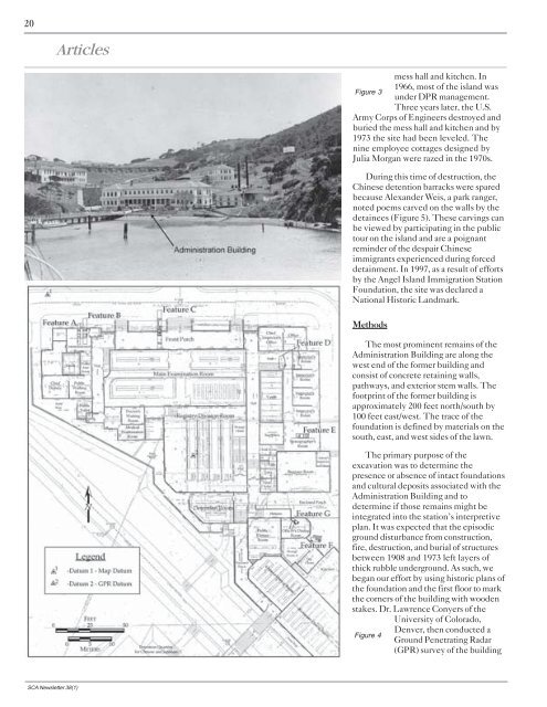
mess hall and kitchen. In<br />
1966, most of the island was<br />
Figure 3<br />
under DPR management.<br />
Three years later, the U.S.<br />
Army Corps of Engineers destroyed and<br />
buried the mess hall and kitchen and by<br />
1973 the site had been leveled. The<br />
nine employee cottages designed by<br />
Julia Morgan were razed in the 1970s.<br />
During this time of destruction, the<br />
Chinese detention barracks were spared<br />
because Alexander Weis, a park ranger,<br />
noted poems carved on the walls by the<br />
detainees (Figure 5). These carvings can<br />
be viewed by participating in the public<br />
tour on the island and are a poignant<br />
reminder of the despair Chinese<br />
immigrants experienced during <strong>for</strong>ced<br />
detainment. In 1997, as a result of ef<strong>for</strong>ts<br />
by the Angel Island Immigration Station<br />
Foundation, the site was declared a<br />
National Historic Landmark.<br />
Methods<br />
The most prominent remains of the<br />
Administration Building are along the<br />
west end of the <strong>for</strong>mer building and<br />
consist of concrete retaining walls,<br />
pathways, and exterior stem walls. The<br />
footprint of the <strong>for</strong>mer building is<br />
approximately 200 feet north/south by<br />
100 feet east/west. The trace of the<br />
foundation is defined by materials on the<br />
south, east, and west sides of the lawn.<br />
The primary purpose of the<br />
excavation was to determine the<br />
presence or absence of intact foundations<br />
and cultural deposits associated with the<br />
Administration Building and to<br />
determine if those remains might be<br />
integrated into the station’s interpretive<br />
plan. It was expected that the episodic<br />
ground disturbance from construction,<br />
fire, destruction, and burial of structures<br />
between 1908 and 1973 left layers of<br />
thick rubble underground. As such, we<br />
began our ef<strong>for</strong>t by using historic plans of<br />
the foundation and the first floor to mark<br />
the corners of the building with wooden<br />
stakes. Dr. Lawrence Conyers of the<br />
University of Colorado,<br />
Denver, then conducted a<br />
Figure 4<br />
Ground Penetrating Radar<br />
(GPR) survey of the building<br />
SCA Newsletter 38(1)