March 2004 - Society for California Archaeology
March 2004 - Society for California Archaeology
March 2004 - Society for California Archaeology

You also want an ePaper? Increase the reach of your titles
YUMPU automatically turns print PDFs into web optimized ePapers that Google loves.
36<br />
Articles<br />
Enormous quantities of soil would have<br />
needed to be removed and stockpiled and<br />
there would have been excessive heavy<br />
equipment and crew costs involved. It was<br />
decided that the budget could be spent more<br />
efficiently on the remaining city blocks. We<br />
had to be content with demonstrating that<br />
the wall foundations of St. Mary’s were solid,<br />
intact, and deep.<br />
Block 10 (Harrison, Bryant, Third and<br />
Fourth) presented a different challenge.<br />
Located on the edge of the 1850s bay marsh<br />
this block saw the largest excavation area cut<br />
a swathe through the historical remains of<br />
what had been the most densely crowded<br />
19th century housing in the project area.<br />
Below as much as eight feet of landfill, 1906<br />
fire-scarred building foundations survived<br />
along with many privies and two deep wells<br />
that produced the bulk of artifacts recovered<br />
during the project. Innovation was the rule<br />
on this block. Ground penetration radar was<br />
used to attempt to peer through six feet or<br />
more of landfill in advance of excavation. Two ASAs were<br />
selected and a Caltrans crew from Sacramento brought in state<br />
of the art GPR equipment to probe beneath the post-1906<br />
sand and rubble fill near the Third Street edge of Block 10.<br />
Initial results indicated that the fill deposits may have<br />
attenuated and bounced the signal around substantially but<br />
these results are being refined and reanalyzed. Final data will<br />
become available as soon as a Caltrans GPR backlog related<br />
to other construction projects has been cleared.<br />
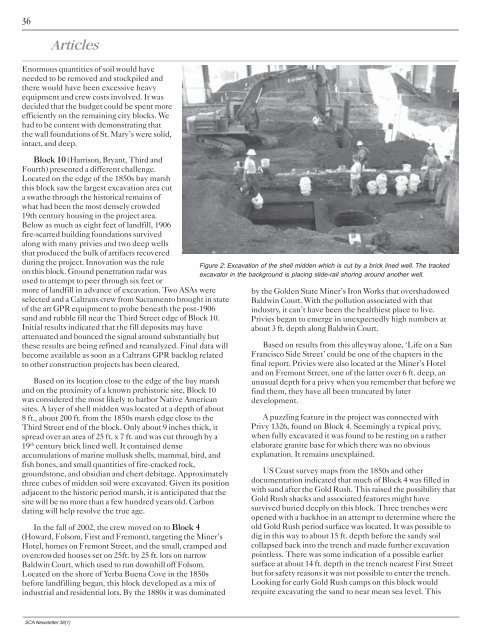
Based on its location close to the edge of the bay marsh<br />
and on the proximity of a known prehistoric site, Block 10<br />
was considered the most likely to harbor Native American<br />
sites. A layer of shell midden was located at a depth of about<br />
8 ft., about 200 ft. from the 1850s marsh edge close to the<br />
Third Street end of the block. Only about 9 inches thick, it<br />
spread over an area of 25 ft. x 7 ft. and was cut through by a<br />
19 th century brick lined well. It contained dense<br />
accumulations of marine mollusk shells, mammal, bird, and<br />
fish bones, and small quantities of fire-cracked rock,<br />
groundstone, and obsidian and chert debitage. Approximately<br />
three cubes of midden soil were excavated. Given its position<br />
adjacent to the historic period marsh, it is anticipated that the<br />
site will be no more than a few hundred years old. Carbon<br />
dating will help resolve the true age.<br />
In the fall of 2002, the crew moved on to Block 4<br />
(Howard, Folsom, First and Fremont), targeting the Miner’s<br />
Hotel, homes on Fremont Street, and the small, cramped and<br />
overcrowded houses set on 25ft. by 25 ft. lots on narrow<br />
Baldwin Court, which used to run downhill off Folsom.<br />
Located on the shore of Yerba Buena Cove in the 1850s<br />
be<strong>for</strong>e landfilling began, this block developed as a mix of<br />
industrial and residential lots. By the 1880s it was dominated<br />
Figure 2: Excavation of the shell midden which is cut by a brick lined well. The tracked<br />
excavator in the background is placing slide-rail shoring around another well.<br />
by the Golden State Miner’s Iron Works that overshadowed<br />
Baldwin Court. With the pollution associated with that<br />
industry, it can’t have been the healthiest place to live.<br />
Privies began to emerge in unexpectedly high numbers at<br />
about 3 ft. depth along Baldwin Court.<br />
Based on results from this alleyway alone, ‘Life on a San<br />
Francisco Side Street’ could be one of the chapters in the<br />
final report. Privies were also located at the Miner’s Hotel<br />
and on Fremont Street, one of the latter over 6 ft. deep, an<br />
unusual depth <strong>for</strong> a privy when you remember that be<strong>for</strong>e we<br />
find them, they have all been truncated by later<br />
development.<br />
A puzzling feature in the project was connected with<br />
Privy 1326, found on Block 4. Seemingly a typical privy,<br />
when fully excavated it was found to be resting on a rather<br />
elaborate granite base <strong>for</strong> which there was no obvious<br />
explanation. It remains unexplained.<br />
US Coast survey maps from the 1850s and other<br />
documentation indicated that much of Block 4 was filled in<br />
with sand after the Gold Rush. This raised the possibility that<br />
Gold Rush shacks and associated features might have<br />
survived buried deeply on this block. Three trenches were<br />
opened with a backhoe in an attempt to determine where the<br />
old Gold Rush period surface was located. It was possible to<br />
dig in this way to about 15 ft. depth be<strong>for</strong>e the sandy soil<br />
collapsed back into the trench and made further excavation<br />
pointless. There was some indication of a possible earlier<br />
surface at about 14 ft. depth in the trench nearest First Street<br />
but <strong>for</strong> safety reasons it was not possible to enter the trench.<br />
Looking <strong>for</strong> early Gold Rush camps on this block would<br />
require excavating the sand to near mean sea level. This<br />
SCA Newsletter 38(1)