Balochistan - NDMA
Balochistan - NDMA
Balochistan - NDMA

You also want an ePaper? Increase the reach of your titles
YUMPU automatically turns print PDFs into web optimized ePapers that Google loves.
PROVINCIAL DISASTER MANAGEMENT AUTHORITY - BALOCHISTAN<br />
B. CLIMATE<br />
The climate of <strong>Balochistan</strong> is continental semi- arid Mediterranean, with annual<br />
precipitation varying from 200 to 350 mm and a variable proportion of this total fall as<br />
moisture of snow and rain in the mid winter period or as intense showers in summer.<br />
The uniform aridity (nowhere exceeding 400 mm on average annually, but in many parts<br />
as low as 50 mm annually) makes un-irrigated agriculture impossible.<br />
The climate of the upper highlands is characterized by very cold winters and warm<br />
summers. Winters of the lower highlands vary from extremely cold in the northern<br />
districts to mild conditions closer to the Makran coast. Summers are hot and dry. The<br />
arid zones of Chaghi and Kharan districts are extremely hot in summer. The plain areas<br />
are also very hot in summer with temperatures rising as high as 120 degrees F (50<br />
degrees C). Winters are mild on the plains with the temperature, never falling below the<br />
freezing point. The desert climate is characterized by hot and very arid conditions.<br />
Occasionally strong windstorms make these areas very inhospitable.<br />
C. RIVERS & STREAMS SYSTEM IN BALOCHISTAN:<br />
All rivers and streams are part of three major drainage systems. Coastal drainage system<br />
is characterized by small, ephemeral streams and hill torrents. Nari, Kaha and Gaj rivers<br />
are part of Indus drainage system located in the northeastern margins of the province.<br />
The flow in rivers is typified by spring runoff and occasional flash floods. The rivers beds<br />
are dry and look like small streams. Stream gradients are high and the rate of runoff is<br />
very rapid. The Zhob River Basin drains towards the northeast into the Gomal River<br />
which ultimately joins the Indus River. Streams along the border of Punjab and Sindh<br />
provinces flow toward the east and southeast into the Indus River. <strong>Balochistan</strong> has canal<br />
system in district Naseerabad, Jaffarabad and Jhal Magsi.<br />
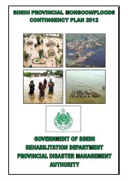
D. HAZARD &RISK ANALYSIS<br />
<strong>Balochistan</strong> has been traditionally vulnerable to natural disasters on account of its<br />
unique geo-climatic conditions. Earthquakes, floods, droughts, cyclones, and landslides<br />
have been recurrent phenomena. Cyclone Yemyen, Ziarat Earthquake and Floods 2010<br />
sufficiently highlighted <strong>Balochistan</strong>’s vulnerability to sea based cyclones, earthquakes,<br />
flash & riverine floods caused by heavy precipitation. Historical records indicate earlier<br />
occurrence of similar emergency and disaster situations. The hazard chart below depicts<br />
the vulnerability of all districts exposed to different kind of hazards.<br />
MONSOON CONTINGENCY PLANNING - 2012 Page 9