Sanderling Plan - Western Hemisphere Shorebird Reserve Network
Sanderling Plan - Western Hemisphere Shorebird Reserve Network
Sanderling Plan - Western Hemisphere Shorebird Reserve Network

Create successful ePaper yourself
Turn your PDF publications into a flip-book with our unique Google optimized e-Paper software.
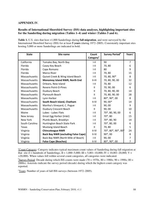
APPENDIX IV.<br />
Results of International <strong>Shorebird</strong> Survey (ISS) data analyses, highlighting important sites<br />
for the <strong>Sanderling</strong> during migration (Tables 1–4) and winter (Tables 5 and 6).<br />
Table 1. U.S. sites that host >1,000 <strong>Sanderling</strong>s during fall migration, and were surveyed by the<br />
International <strong>Shorebird</strong> Survey (ISS) for at least 5 years (during 1972–2005). Consistently important sites<br />
hosting 5,000 or more <strong>Sanderling</strong>s are indicated in bold.<br />
State Site name Count<br />
Category a Survey Period b Years c<br />
California<br />
Florida<br />
Florida<br />
Florida<br />
Massachusetts<br />
Massachusetts<br />
Massachusetts<br />
Massachusetts<br />
Massachusetts<br />
Massachusetts<br />
Massachusetts<br />
Massachusetts<br />
Massachusetts<br />
Massachusetts<br />
Maine<br />
New Jersey<br />
New York<br />
South Carolina<br />
Texas<br />
Virginia<br />
Virginia<br />
Virginia<br />
Virginia<br />
Tomales Bay, North Bay<br />
Casey Key Beach<br />
Cape Romano<br />
Marco River<br />
Quivet Creek & Wing Island Beach<br />
Monomoy Island NWR, North End<br />
Orleans, New Island<br />
Revere Point-O-Pines<br />
Duxbury Beach<br />
Plymouth Beach<br />
Lynn Harbor<br />
South Beach Island, Chatham<br />
Martha's Vineyard, C. Pogue<br />
Duxbury Crescent Beach<br />
Lubec - Lubec Flats<br />
Great Egg Harbor (Inlet)<br />
Plumb Beach, Brooklyn<br />
Huntington Beach State Park<br />
Mustang Island Beach<br />
Chincoteague NWR<br />
Back Bay NWR (excluding False Cape)<br />
Back Bay NWR (North Mile of Beach)<br />
False Cape (Beaches)<br />
I-II<br />
I-II<br />
I-II<br />
I-II<br />
I-II<br />
II-III<br />
I-II<br />
II<br />
II<br />
II<br />
I-II<br />
II-IV<br />
I-II<br />
II<br />
I-II<br />
I-II<br />
I-II<br />
I-II<br />
II<br />
II-IV<br />
II-IV<br />
I-II<br />
II-IV<br />
90<br />
70, 80<br />
80<br />
70, 80<br />
70, 80, 90*<br />
70, 80, 90, 00<br />
70, 80<br />
70, 90, 00<br />
70, 80, 90, 00<br />
70, 80, 90, 00<br />
80*, 90*, 00<br />
90, 00*<br />
90, 00<br />
90, 00<br />
70*, 80, 90, 00<br />
70*, 80<br />
70*, 80, 90<br />
70*, 80, 00<br />
70, 80<br />
70*, 80*, 90*, 00*<br />
90*, 00<br />
90, 00<br />
80*, 90*, 00<br />
7<br />
6<br />
9<br />
15<br />
8<br />
32<br />
12<br />
6<br />
14<br />
28<br />
8<br />
14<br />
9<br />
10<br />
6<br />
15<br />
14<br />
6<br />
5<br />
24<br />
8<br />
7<br />
7<br />
a Count Category: Category indicates typical maximum count values of <strong>Sanderling</strong> during fall migration at<br />
that site (I = hundreds of <strong>Sanderling</strong>s; II = 1,000–5,000; III = 5,001–10,000; IV = 10,001–20,000; V =<br />
>20,000). When values fell within several count categories, all categories were indicated.<br />
b Survey Period: Decade during which ISS counts were made (70 = 1970s, 80 = 1980s; 90 = 1990s; 00 =<br />
2000s). Asterisks indicate the survey period (decade) during which the highest count category was<br />
reported.<br />
c Years: Number of years of fall ISS surveys (between 1972–2005).<br />
WHSRN – <strong>Sanderling</strong> Conservation <strong>Plan</strong>, February 2010, v1.1 88