Sanderling Plan - Western Hemisphere Shorebird Reserve Network
Sanderling Plan - Western Hemisphere Shorebird Reserve Network
Sanderling Plan - Western Hemisphere Shorebird Reserve Network

Create successful ePaper yourself
Turn your PDF publications into a flip-book with our unique Google optimized e-Paper software.
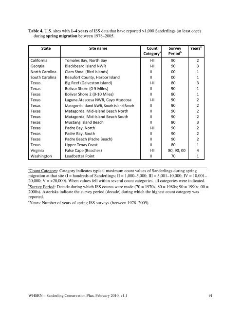
Table 4. U.S. sites with 1–4 years of ISS data that have reported >1,000 <strong>Sanderling</strong>s (at least once)<br />
during spring migration between 1978–2005.<br />
State Site name Count<br />
Category a<br />
California<br />
Georgia<br />
North Carolina<br />
South Carolina<br />
Texas<br />
Texas<br />
Texas<br />
Texas<br />
Texas<br />
Texas<br />
Texas<br />
Texas<br />
Texas<br />
Texas<br />
Texas<br />
Texas<br />
Virginia<br />
Washington<br />
Tomales Bay, North Bay<br />
Blackbeard Island NWR<br />
Clam Shoal (Bird Islands)<br />
Beaufort County, Harbor Island<br />
Big Reef (Galveston Island)<br />
Bolivar Shore (0-5 Miles)<br />
Bolivar Shore 2 (0-10 Miles)<br />
Laguna Atascosa NWR, Cayo Atascosa<br />
Matagorda Island NWR, South Island Beach<br />
Matagorda, Mid-Island Beach North<br />
Matagorda, Mid-Island Beach South<br />
Mustang Island Beach<br />
Padre Bay, North<br />
Padre Bay, South<br />
Padre Beach (Padre Beach)<br />
Upper Texas Coast<br />
False Cape (Beaches)<br />
Leadbetter Point<br />
I-II<br />
I-II<br />
II<br />
II<br />
I-II<br />
II<br />
II<br />
I-II<br />
II<br />
II<br />
II<br />
II<br />
I-II<br />
II<br />
II<br />
II<br />
I-II<br />
II<br />
Survey<br />
Period b<br />
90<br />
90<br />
00<br />
00<br />
80<br />
90<br />
80<br />
90<br />
90<br />
90<br />
90<br />
80<br />
90<br />
90<br />
90<br />
80<br />
80, 90, 00<br />
70<br />
Years c<br />
2<br />
3<br />
1<br />
1<br />
3<br />
1<br />
1<br />
2<br />
2<br />
2<br />
2<br />
3<br />
2<br />
2<br />
2<br />
1<br />
4<br />
1<br />
a Count Category: Category indicates typical maximum count values of <strong>Sanderling</strong>s during spring<br />
migration at that site (I = hundreds of <strong>Sanderling</strong>s; II = 1,000–5,000; III = 5,001–10,000; IV = 10,001–<br />
20,000; V = >20,000). When values fell within several count categories, all categories were indicated.<br />
b Survey Period: Decade during which ISS counts were made (70 = 1970s, 80 = 1980s; 90 = 1990s; 00 =<br />
2000s). Asterisks indicate the survey period (decade) during which the highest count category was<br />
reported.<br />
c Years: Number of years of spring ISS surveys (between 1978–2005).<br />
WHSRN – <strong>Sanderling</strong> Conservation <strong>Plan</strong>, February 2010, v1.1 91