

DRAFT Tuart Conservation and Management Strategy
DRAFT Tuart Conservation and Management Strategy
DRAFT Tuart Conservation and Management Strategy

Create successful ePaper yourself
Turn your PDF publications into a flip-book with our unique Google optimized e-Paper software.
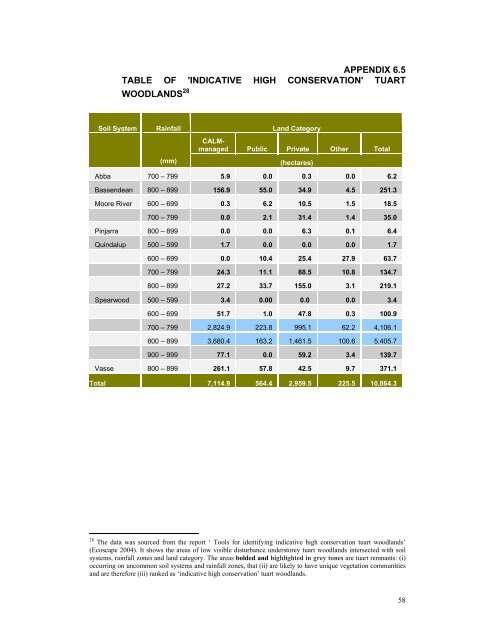
APPENDIX 6.5<br />
TABLE OF 'INDICATIVE HIGH CONSERVATION' TUART<br />
WOODLANDS 28<br />
Soil System Rainfall L<strong>and</strong> Category<br />
(mm)<br />
CALMmanaged<br />
Public Private Other Total<br />
(hectares)<br />
Abba 700 – 799 5.9 0.0 0.3 0.0 6.2<br />
Bassendean 800 – 899 156.9 55.0 34.9 4.5 251.3<br />
Moore River 600 – 699 0.3 6.2 10.5 1.5 18.5<br />
700 – 799 0.0 2.1 31.4 1.4 35.0<br />
Pinjarra 800 – 899 0.0 0.0 6.3 0.1 6.4<br />
Quindalup 500 – 599 1.7 0.0 0.0 0.0 1.7<br />
600 – 699 0.0 10.4 25.4 27.9 63.7<br />
700 – 799 24.3 11.1 88.5 10.8 134.7<br />
800 – 899 27.2 33.7 155.0 3.1 219.1<br />
Spearwood 500 – 599 3.4 0.00 0.0 0.0 3.4<br />
600 – 699 51.7 1.0 47.8 0.3 100.9<br />
700 – 799 2,824.9 223.8 995.1 62.2 4,106.1<br />
800 – 899 3,680.4 163.2 1,461.5 100.6 5,405.7<br />
900 – 999 77.1 0.0 59.2 3.4 139.7<br />
Vasse 800 – 899 261.1 57.8 42.5 9.7 371.1<br />
Total 7,114.9 564.4 2,959.5 225.5 10,864.3<br />
28 The data was sourced from the report ‘ Tools for identifying indicative high conservation tuart woodl<strong>and</strong>s’<br />
(Ecoscape 2004). It shows the areas of low visible disturbance understorey tuart woodl<strong>and</strong>s intersected with soil<br />
systems, rainfall zones <strong>and</strong> l<strong>and</strong> category. The areas bolded <strong>and</strong> highlighted in grey tones are tuart remnants: (i)<br />
occurring on uncommon soil systems <strong>and</strong> rainfall zones, that (ii) are likely to have unique vegetation communities<br />
<strong>and</strong> are therefore (iii) ranked as ‘indicative high conservation’ tuart woodl<strong>and</strong>s.<br />
58


