Kabul Urban Survey - Groupe URD
Kabul Urban Survey - Groupe URD
Kabul Urban Survey - Groupe URD

You also want an ePaper? Increase the reach of your titles
YUMPU automatically turns print PDFs into web optimized ePapers that Google loves.
Previously, the satellite map system was reserved for military use. This type of spatial<br />
representation is now benefiting numerous civil activities, of which the urban sector is one.<br />
Different sources of satellite map are available and can be used for certain types of data,<br />
although using them for urban issues is not so apparent. Given the lack of existing urban<br />
plans with the right scale and that show the correct position of buildings and streets, and<br />
given the time involved in establishing precise cadastral plans, urban planning organisations<br />
often design their own spatial urban background for implementing programmes and projects.<br />
The satellite map is one of these supports. This is the case for the majority of actors such as<br />
urban institutional actors, international organisations or private operators design their own<br />
spatial data. All urban actors, including some institutional urban survey teams have access to<br />
satellite maps and use them as a background such as for regularising land tenure issues, for<br />
urban development, for reorganising existing urban areas, or for implementing rehabilitation<br />
programmes, etc. In this transitional period, with an absence of urban plans, satellite maps<br />
allow urban planners to: identify where to carry out their assessment, decide the limits of<br />
their programmes, design their projects, communicate and coordinate their activities, improve<br />
their decision making. International access to this database is useful to allow international aid<br />
organisations to plan their activities and to ensure that the different urban actors have a<br />
shared understanding of the spatial situation.<br />
This is the case for urban administrations such as the MoUD for the <strong>Kabul</strong> <strong>Urban</strong><br />
Rehabilitation Programme (KURP) or for the Rehabilitation of <strong>Kabul</strong> Old Town survey<br />
programme. The Central Administration of Water Supply and Sewerage (CAWSS) also<br />
uses this background information for monitoring the water supply networks drawn by<br />
international organisations on satellite maps by the ICRC, Care International or NGOs.<br />
Different urban actors use them.<br />
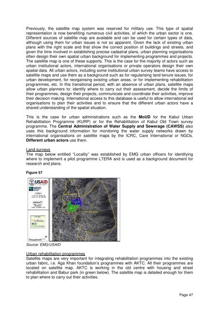
Land surveys<br />
The map below entitled “Locality” was established by EMG urban officers for identifying<br />
where to implement a pilot programme LTERA and is used as a background document for<br />
research and plans.<br />
Figure 57<br />
Source: EMG/USAID<br />
<strong>Urban</strong> rehabilitation programmes<br />
Satellite maps are very important for integrating rehabilitation programmes into the existing<br />
urban fabric, i.e. Aga Khan foundation’s programmes with AKTC. All their programmes are<br />
located on satellite map. AKTC is working in the old centre with housing and street<br />
rehabilitation and Babur park (in green below). The satellite map is detailed enough for them<br />
to plan where to carry out their activities.<br />
Page 47